Stormlea is a rural locality in the local government area (LGA) of Tasman in the South-east LGA region of Tasmania. The locality is about 12 kilometres...
3 KB (189 words) - 18:13, 25 July 2024
survey lines. Route B37 (Nubeena Road) passes to the north. From there, Stormlea Road provides access to the locality. "2016 Census Quick Stats Highcroft...
3 KB (171 words) - 17:12, 25 July 2024

is a list of all bounded localities in Tasmania, Australia, as recognised by the Land Information System Tasmania. The definition of a locality for this...
130 KB (178 words) - 18:10, 14 February 2022
local government area (LGA) of Tasman in the South-east LGA region of Tasmania. The locality is about 6 kilometres (3.7 mi) south-west of the town of...
3 KB (181 words) - 18:27, 25 July 2024
Tasman Council (category Local government areas of Tasmania)
Nubeena • Port Arthur • Premaydena • Saltwater River • Sloping Main • Stormlea • Taranna • White Beach Tasman Council is composed of seven councillors...
6 KB (375 words) - 01:57, 19 April 2024
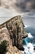
Cape Raoul (category Towns in Tasmania)
end of the plateau. The cape is accessed via Port Arthur at the end of Stormlea Road. The columns at the cape appear to be a colonnade formed from columnar...
6 KB (547 words) - 16:44, 25 July 2024
Tasman Peninsula (category East Coast Tasmania)
Nubeena and Koonya. Smaller centres include Premaydena, Highcroft and Stormlea. The Conservation Park, located on the main highway at Taranna, is a popular...
10 KB (1,112 words) - 17:41, 24 May 2024