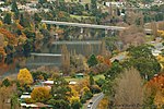
Strathgordon is a rural locality in the local government area (LGA) of Derwent Valley in the South-east LGA region of Tasmania. The locality is about 121...
8 KB (488 words) - 18:13, 25 July 2024
of The Citadel. Lake Pedder Strathgordon, Tasmania South West Wilderness, Tasmania Solitary 4224, Edition 1 2001, Tasmania 1:25000 Series, Tasmap v t e...
1 KB (76 words) - 04:13, 2 April 2022
Cleft Peak (redirect from Cleft Peak, Tasmania)
West of Greycap. Lake Pedder Strathgordon, Tasmania South West Wilderness, Tasmania Solitary 4224, Edition 1 2001, Tasmania 1:25000 Series, Tasmap v t e...
1 KB (66 words) - 22:27, 6 July 2024

West Coast (44%). Its central point, near the encircled locality of Strathgordon, is about 116 kilometres (72 mi) west of the town of New Norfolk, the...
11 KB (1,042 words) - 18:09, 25 July 2024
Councils of Tasmania are the 29 administrative districts of the Australian state of Tasmania. Local government areas (LGAs), more generally known as councils...
22 KB (787 words) - 08:22, 21 July 2024

Maydena (redirect from Maydena, Tasmania)
Road continues to Lake Pedder, Lake Gordon and Strathgordon, in the Southwest National Park of Tasmania. Maydena was formerly called Junee and was a small...
7 KB (451 words) - 10:05, 28 April 2023

complex includes boudinage structure and en echelon veins. Phyllite near Strathgordon has been dated at 1,100 to 1,150 million years ago. Metamorphism to greenschist...
80 KB (11,155 words) - 08:47, 14 July 2024

Lake Pedder (redirect from Lake Pedder Tasmania)
Arthurs mountain range and the other at a modified water supply dam near Strathgordon. To coincide with the United Nations Decade of Ecological Restoration...
24 KB (2,259 words) - 06:36, 26 June 2024
Frankland Peak (redirect from Frankland Peak, Tasmania)
north of Right Angle Peak. Strathgordon, Tasmania South West Wilderness, Tasmania Solitary 4224, Edition 1 2001, Tasmania 1:25000 Series, Tasmap v t e...
1 KB (55 words) - 12:42, 1 April 2022

Southwest National Park (category National parks of Tasmania)
the area there is only one road, to the hydroelectricity township of Strathgordon. The southern and western reaches of the park are far removed from any...
31 KB (3,722 words) - 02:18, 29 July 2024
Recreation Day holiday (category Northern Tasmania)
southern Tasmania. It is observed in all parts of Tasmania north of (but not including) Oatlands and Swansea [1]. This area includes Strathgordon, Tarraleah...
2 KB (144 words) - 03:09, 27 May 2024

Derwent Valley Council (category Local government areas of Tasmania)
Sorell Creek Strathgordon Styx Tyenna Uxbridge Wellington Park (part) Westerway (part) Southwest (part) List of local government areas of Tasmania "3218.0...
7 KB (356 words) - 11:17, 28 January 2024
of Hobart) to the remote south-west Hydro town of Strathgordon Electoral division of Derwent, Tasmania Derwent Barracks, an Australian Army barracks in...
6 KB (864 words) - 23:23, 11 March 2024
in Tasmania. It would have passed through a route somewhat similar to the current Lyell Highway through the northern edge of South West Tasmania into...
4 KB (519 words) - 02:56, 5 July 2024

Snow in Australia (section Victoria and Tasmania)
highlands of the southeast, in the states of New South Wales, Victoria, Tasmania and in the Australian Capital Territory. Snow is rare even in the southernmost...
36 KB (3,574 words) - 23:27, 25 September 2024
Gordon River Road (category Roads in Tasmania)
Gordon River Road, sometimes called the Strathgordon Road, (B61), is a road in the south western region of Tasmania, Australia. The 85-kilometre (53 mi)...
4 KB (398 words) - 13:30, 24 January 2024

Frankland Range (category Mountain ranges of Tasmania)
Access routes to the range are by boat from the lake, or the roads at Strathgordon or Scotts Peak Dam. Nearby ranges include the Arthur, Companion, Folded...
6 KB (189 words) - 00:00, 9 May 2024
Terminal Peak (redirect from Terminal Peak, Tasmania)
surrounded by Lake Pedder. Lake Pedder Strathgordon, Tasmania South West Wilderness, Tasmania Solitary 4224, Edition 1 2001, Tasmania 1:25000 Series, Tasmap...
1 KB (78 words) - 15:33, 19 July 2024
Redtop Peak (redirect from Redtop Peak, Tasmania)
to the west of The Cupola. Lake Pedder Strathgordon, Tasmania South West Wilderness Solitary, Edition 1 2001, Tasmania 1:25000 Series, Tasmap v t e...
1 KB (59 words) - 04:14, 2 April 2022
Greycap (redirect from Greycap, Tasmania)
sloping sides. Lake Pedder Strathgordon, Tasmania South West Wilderness, Tasmania Solitary 4224, Edition 1 2001, Tasmania 1:25000 Series, Tasmap v t e...
1 KB (75 words) - 04:02, 2 April 2022
Secheron Peak (redirect from Secheron Peak, Tasmania)
one kilometre to the southwest. Strathgordon, Tasmania South West Wilderness, Tasmania Maconochie 4223, Edition 1 2003, Tasmania 1:25000 Series, Tasmap...
1 KB (63 words) - 12:42, 1 April 2022

is a list of all bounded localities in Tasmania, Australia, as recognised by the Land Information System Tasmania. The definition of a locality for this...
130 KB (178 words) - 18:10, 14 February 2022
The Cupola (mountain) (redirect from The Cupola, Tasmania)
dome. Australia portal Mountains portal List of mountains in Tasmania Strathgordon, Tasmania "The Cupola (TAS)". Gazetteer of Australia online. Geoscience...
3 KB (123 words) - 21:45, 26 April 2022
New Norfolk (redirect from New Norfolk, Tasmania)
located on the River Derwent in southeastern Tasmania, Australia. Established in 1807, it is Tasmania’s fourth-oldest European settlement and ranks as...
35 KB (3,748 words) - 14:34, 20 September 2024

South West Wilderness (redirect from South West Wilderness, Tasmania)
located on Lake Pedder. The Ted's Beach campground is located 10 km from Strathgordon on the East bank of the lake. The facilities there include electric barbecues...
12 KB (1,514 words) - 15:04, 28 August 2024
Right Angle Peak (redirect from Right Angle Peak, Tasmania)
is south west of Secheron Peak. Strathgordon, Tasmania South West Wilderness, Tasmania Maconochie 4223, Edition 1 2003, Tasmania 1:25000 Series, Tasmap...
1 KB (61 words) - 03:20, 25 May 2024
Murpheys Bluff (redirect from Murpheys Bluff, Tasmania)
the North West. Lake Pedder Strathgordon, Tasmania South West Wilderness, Tasmania Solitary 4224, Edition 1 2001, Tasmania 1:25000 Series, Tasmap v t e...
1 KB (76 words) - 04:16, 2 April 2022
The Citadel (mountain) (redirect from The Citadel, Tasmania)
an alpine lake. Lake Pedder Strathgordon, Tasmania South West Wilderness, Tasmania Solitary 4224, Edition 1 2001, Tasmania 1:25000 Series, Tasmap v t e...
1 KB (78 words) - 12:41, 1 April 2022
Mount Lloyd Jones (redirect from Mount Lloyd Jones, Tasmania)
Secheron Peak. Lake Pedder Strathgordon, Tasmania South West Wilderness, Tasmania [1] Solitary 4224, Edition 1 2001, Tasmania 1:25000 Series, Tasmap v t...
1 KB (93 words) - 04:15, 2 April 2022
Derwent Valley is a river valley and geographic area located in southern Tasmania, Australia. The largest town is New Norfolk, with other smaller towns spread...
11 KB (995 words) - 00:43, 2 September 2024