
A stream gauge, streamgage or stream gauging station is a location used by hydrologists or environmental scientists to monitor and test terrestrial bodies...
14 KB (1,637 words) - 09:58, 5 February 2024
pressure above ambient pressure Stream gauge, for measuring height and discharge of a river or stream Air core gauge, a type of rotary actuator often...
3 KB (376 words) - 21:58, 21 February 2024

fringe. Streamflow The water moving through a stream channel. Stream gauge A site along the route of a stream or river, used for reference marking or water...
36 KB (3,863 words) - 12:34, 28 August 2024
upstream of a stream gauge near Kindred and at river mile 67.9 (river kilometer 109.3). This is the average flow measured by a stream gauge near Kindred...
60 KB (3,176 words) - 22:31, 23 June 2024
Water level (redirect from Gauge height)
Water level, also known as gauge height or stage, is the elevation of the free surface of a sea, stream, lake or reservoir relative to a specified vertical...
1 KB (80 words) - 03:52, 29 April 2024

The Embudo Stream Gauging Station is a stream gauge established in 1888 as the United States Geologic Survey's first training center for hydrographers...
4 KB (407 words) - 02:35, 18 December 2020

Oceans portal Level sensor Sea level rise Stream gauge Fort Denison#Tide gauge "The Kronstadt sea-gauge". Your Guide in St Petersburg. Retrieved 26...
9 KB (865 words) - 20:21, 27 July 2024
Because of the difficulties of measurement, a stream gauge is often used at a fixed location on the stream or river. A hydrograph is a graph showing the...
10 KB (1,341 words) - 09:43, 7 April 2024
Streamflow (redirect from Stream flow)
pipes. The discharge of water flowing in a channel is measured using stream gauges or can be estimated by the Manning equation. The record of flow over...
15 KB (2,086 words) - 01:59, 8 August 2024

Sope Creek (section Stream gauges)
Elementary School, Sope Creek Nature Trails, and Sope Creek Homes. The stream gauge on Sope Creek (MARG1) is mounted to the south side of the Lower Roswell...
22 KB (3,361 words) - 23:49, 22 October 2021

of approximately 500 stream gages collecting real time data from all across the state. This then contributes to the 8,000 stream gage stations that are...
9 KB (970 words) - 12:49, 18 May 2024

Neckar (section Stream gauge and flood)
Hochwassermeldehöhen are valid at the stream gauge: Gauge Plochingen The gauge in Plochingen (since 1905) was the only gauge at the waterway that lay in free...
82 KB (9,581 words) - 07:37, 20 August 2024

12-gauge has a bore diameter of .729 in (18.5 mm). 12-gauge and 20-gauge shotguns are the most popular gauges in the United States. The 20-gauge is popular...
8 KB (725 words) - 10:28, 2 July 2024
areal floodplains. Flood stage is the water level, as read by a stream gauge or tide gauge, for a body of water at a particular location, measured from the...
8 KB (1,055 words) - 04:30, 16 April 2024

Chalk streams are rivers that rise from springs in landscapes with chalk bedrock. Since chalk is permeable, water percolates easily through the ground...
14 KB (1,435 words) - 06:04, 19 July 2024
added together. Shreve stream order is preferred in hydrodynamics: it sums the number of sources in each catchment above a stream gauge or outflow, and correlates...
11 KB (1,533 words) - 19:14, 25 May 2024
Psychrometer Rain gauge Rain sensor Seismometer SNOTEL Snow gauge Soil moisture sensor Stream gauge Tide gauge Weather radar Air flow meter Anemometer Flow sensor...
12 KB (1,021 words) - 04:16, 7 March 2024
staff gauge is usually calibrated so that the indicated level is the true vertical level. Staff gauges are commonly installed at stream gauging stations...
852 bytes (92 words) - 21:53, 7 October 2022

Caldwell, Dexter City and Macksburg; it is the larger of the two headwaters streams. From Warner, Duck Creek flows generally southwardly in a highly meandering...
7 KB (305 words) - 15:07, 15 January 2022

Peachtree Creek, stream gauge at Northside Drive South Fork Peachtree Creek, stream gauge at Johnson Road North Fork Peachtree Creek, stream gauge at Buford...
8 KB (1,102 words) - 22:35, 5 February 2023
breathing gas cylinder used in scuba diving Stage (stream gauge), a measurement of water level in a river, stream, pond, lake, or estuary The platform and that...
4 KB (469 words) - 14:47, 8 July 2024

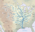
(570 m3/s), for the 1906–2023 period. River flows at the Lees Ferry stream gauge, about halfway along the length of the Colorado and 16 miles (26 km)...
246 KB (23,449 words) - 01:16, 26 August 2024
764967°E / 50.085433; 7.764967 The Kaub gauging station (German: Pegel Kaub, Kauber Pegel) is a stream gauge located on the Rhine river in the German...
6 KB (703 words) - 18:47, 22 October 2022

Drainage basin (category Water streams)
Measurement of the discharge of water from a basin may be made by a stream gauge located at the basin's outlet. Depending on the conditions of the drainage...
24 KB (2,801 words) - 01:11, 8 July 2024

USGS WaterData: Stream Gauge Blanco River at Wimberly NWS Advanced Hydrologic Prediction at Wimberly WMBT2 USGS WaterData: Stream Gauge Blanco River near...
8 KB (841 words) - 02:05, 16 August 2024
Bourbeuse River, Red Oak Creek, Spring Creek and Voss Creek. The USGS stream gauge in Union, near the mouth of the river, measures an average flow of 692...
3 KB (317 words) - 18:19, 24 July 2023

Fossil Creek (section Stream restoration)
constant 72 °F (22 °C). The United States Geological Survey installed a stream gauge at the Fossil Creek Bridge in 2010. The maximum daily discharge at that...
27 KB (2,834 words) - 19:44, 28 August 2024

discharge, reversing direction and flowing north. At the Surrey Street stream gauge in Lafayette, Louisiana, maximum historic positive discharge was 6,280 ft³/s...
10 KB (906 words) - 18:01, 12 April 2024
water withdrawals the three stream gauge stations below Isabella Dam show a dramatically decreasing discharge. At the last gauge, near Bakersfield, the river's...
51 KB (5,747 words) - 02:10, 24 May 2024

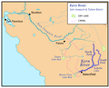
Arkansas River in Bent County. The U.S. Geological Survey maintains a stream gauge along the creek at Highway 194 in Bent County. List of rivers of Colorado...
4 KB (449 words) - 15:58, 17 March 2024