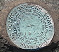
Survey markers, also called survey marks, survey monuments, or geodetic marks, are objects placed to mark key survey points on the Earth's surface. They...
10 KB (1,244 words) - 18:30, 29 November 2023
Corner Survey Marker is a heritage-listed survey marker in the locality of Cameron Corner, Shire of Bulloo, Queensland, Australia. The survey marker is at...
31 KB (4,074 words) - 04:28, 4 November 2024
Henry Washington Survey Marker is a survey marker in San Bernardino National Forest in San Bernardino County, California. The marker served as the earliest...
2 KB (182 words) - 15:30, 28 September 2021
a broad arrow – below the horizontal line. A benchmark is a type of survey marker. The term is generally applied to any item used to mark a point as an...
10 KB (1,053 words) - 17:50, 22 October 2024
pen Paintball marker, or paintball gun, an air gun Survey marker, an object placed to mark a point 4253 Märker, a main belt asteroid Marker, Norway, a municipality...
3 KB (369 words) - 00:10, 28 January 2023
The United States Geological Survey (USGS), founded as the Geological Survey, is an agency of the U.S. Department of the Interior whose work spans the...
36 KB (3,792 words) - 01:03, 12 November 2024
The National Geodetic Survey (NGS) is a United States federal agency based in Washington, D.C. that defines and manages a national coordinate system, providing...
7 KB (762 words) - 18:49, 12 August 2024
Cadastre (redirect from Cadastral Survey)
One such cadastre was done in AD 77 in Campania, a surviving stone marker of the survey reads "The Emperor Vespasian, in the eighth year of his tribunician...
20 KB (2,256 words) - 13:12, 19 September 2024
along the expedition's route. The broad arrow mark was also used on survey markers. It can still be seen on some Australian military property. The broad...
27 KB (3,293 words) - 09:25, 18 October 2024
Poeppel Corner Survey Marker is a heritage-listed survey marker at Poeppel Corner on the border corner of Queensland, South Australia and Northern Territory...
25 KB (3,402 words) - 20:08, 22 January 2024
Tribrach (instrument) (category Surveying instruments)
survey instrument to be repeatedly placed in the same position over a surveying marker point with sub-millimetre precision, by loosening and re-tightening...
5 KB (547 words) - 13:52, 23 December 2023
Territory. The marker was listed on the National Register of Historic Places in 1976. This marker was one of the few surviving markers from this survey that is...
3 KB (238 words) - 17:43, 5 August 2023
Kaibab National Forest. The site contains one of the few remaining survey markers used by the expedition of John Wesley Powell in 1872 It is accessible...
8 KB (900 words) - 01:18, 24 February 2024
Meades Ranch Triangulation Station (category Surveying and geodesy markers)
Triangulation Station is a survey marker in Osborne County in the state of Kansas in the Midwestern United States. The marker was initially placed in 1891...
15 KB (1,486 words) - 22:19, 16 November 2023
"standard" survey error of the time, the originally surveyed location of the "Four Corners" point, along with the corresponding survey marker, was unintentionally...
15 KB (1,617 words) - 15:44, 8 November 2024
Mason–Dixon line (category Historic American Buildings Survey in Pennsylvania)
of Pennsylvania (1855) Historic American Buildings Survey (HABS) No. PA-349, "Mason-Dixon Line Marker, Zora, Adams County, PA", 1 photo, 1 data page, supplemental...
51 KB (5,820 words) - 05:28, 7 November 2024
Plumb bob (category Surveying instruments)
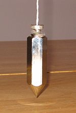
the instrument exactly over a fixed survey marker or to transcribe positions onto the ground for placing a marker. The plumb in plumb bob derives from...
6 KB (624 words) - 00:11, 7 February 2024
Louisiana Purchase State Park (redirect from Louisiana Purchase Survey Marker)
development practices that include draining such areas. On the survey point is a 6-foot (1.8 m) marker erected in 1926 by the L'Anguille Chapter, Daughters of...
11 KB (936 words) - 18:06, 8 October 2024
Milestone (redirect from Mile marker)
A milestone is a numbered marker placed on a route such as a road, railway line, canal or boundary. They can indicate the distance to towns, cities, and...
25 KB (2,770 words) - 17:23, 11 November 2024
equipment; digging implements for finding survey markers buried over time; hammers for placements of markers in various surfaces and structures; and portable...
57 KB (7,269 words) - 02:42, 13 November 2024
Benchmarking (hobby) (category Surveying and geodesy markers)
benchmarks (also known as survey markers or geodetic control points). The term "benchmark" is used only to refer to survey markers that designate a certain...
14 KB (1,841 words) - 21:53, 29 June 2024
de la Harpe. In 1818 the rock was used as a survey marker, and formed the starting point for land surveys in the region south of the river. The Little...
2 KB (178 words) - 14:54, 27 September 2024
A boundary marker, border marker, boundary stone, or border stone is a robust physical marker that identifies the start of a land boundary or the change...
28 KB (3,203 words) - 13:29, 3 November 2024
Ellicott’s Rock is a survey marker placed in 1811 by Andrew Ellicott as part of his survey to resolve the boundary dispute between the U.S. states of...
6 KB (636 words) - 09:13, 15 February 2024
Civil engineering (section Surveying)
when possible; "lay-out" or "setting-out": placing reference points and markers that will guide the construction of new structures such as roads or buildings;...
38 KB (3,984 words) - 22:18, 12 November 2024
Geodetic control network (redirect from Control survey)
velocities. Cadastre Map ED50 Geodetic datum GRS80 History of geodesy Survey marker Triangulation station Trigonometry Rear Adm. John D. Bossler. "Standards...
7 KB (718 words) - 14:11, 14 May 2024
Resort, a ski area in the Cascade Range of Oregon Willamette Stone, survey marker in Oregon Willamette Cattle Company, a company formed in Oregon in 1837...
2 KB (303 words) - 09:24, 14 July 2023
candidates Premature atrial contractions Primary airport control station, a survey marker established in the vicinity of an airport Personal access control system...
2 KB (297 words) - 10:46, 28 June 2022
8 Mile Corner (category Boundary markers)
8 Mile Corner is a survey marker in the Cimarron National Grassland that marks the tri-point (a place where three states meet) of Kansas, Colorado, and...
6 KB (596 words) - 23:40, 24 October 2024
Seven Ranges Terminus (category Surveying of the United States)
Seven Ranges Terminus is a stone surveying marker near Magnolia, Ohio that marks the completion of the first step in opening the lands northwest of the...
7 KB (713 words) - 02:33, 2 April 2023


