The Tanzilla River is a tributary of the Stikine River in northwest part of the province of British Columbia, Canada. From its source in the Three Sisters...
8 KB (666 words) - 23:41, 8 July 2024
Klastline River Kakiddi Creek Tsecha Creek Tenchen Creek Nido Creek Tennaya Creek Sorcery Creek Shaman Creek Chakima Creek Tanzilla River Klappan River Little...
32 KB (2,458 words) - 22:19, 13 May 2024
the lake, straddling a low pass which leads into the basin from the Tanzilla River, a tributary of the Stikine. The area around the lake was the focus...
2 KB (224 words) - 08:56, 5 November 2023

near the Tanzilla River. The larger towns of Wrangell (population 2,127) and Petersburg, Alaska (3,398) are located close to the mouth of the river, but are...
84 KB (9,585 words) - 20:04, 26 February 2024
way) Tahltan River Tahsis River Tahsish River Tahtsa Reach, Tahtsa Lake Takhini River Taku River Talbot Creek Tanzilla River Taseko River Tats Creek Tatsatua...
13 KB (1,123 words) - 22:09, 13 May 2024
to 2 m (7 ft) close to the point where the Tanzilla River enters, a spot known to kayakers as the "Tanzilla Slot". It was originally created in 1836 during...
10 KB (1,124 words) - 09:34, 21 May 2023
from the name of the Taku people Talchako River Tanzilla River, Tanzilla Plateau Taseko Mountain, Taseko River, Taseko Lakes – from the Chilcotin language...
90 KB (10,280 words) - 21:28, 8 July 2024
(Tahltan Forks IR 5) Tatcho Creek IR. No.11, on the right bank of the Tanzilla River, at the mouth of Tatsho Creek, 7 miles SW of Dease Lake (settlement...
6 KB (762 words) - 01:58, 13 April 2024

the Stikine River and the basin of the Spatsizi River. the Tanzilla Plateau lies north of the Stikine River and to the east of the Tuya River and includes...
6 KB (529 words) - 18:46, 9 April 2024
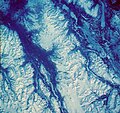
The Tanzilla Plateau is a plateau in the Stikine Country of the Northern Interior of British Columbia, Canada. It is a sub-plateau of the Stikine Plateau...
3 KB (120 words) - 18:43, 9 April 2024
drainage divide separating the basins of the Dease River (to the north) from that of the Tanzilla (to the south), a tributary of the Stikine. As this...
18 KB (692 words) - 05:48, 23 May 2024

west of Okanagan Lake, south of the Thompson River and east of (although never adjoining it) the Fraser River. At its most southern point the plateau is...
6 KB (654 words) - 18:39, 9 April 2024
sometimes defined as part of the Yukon Plateau) Tanzilla Plateau Boya Lake Provincial Park Dall River Old Growth Provincial Park Denetiah Provincial Park...
6 KB (521 words) - 08:46, 8 October 2023
Plateau to the east, and the Tanzilla Plateau to the north, on the other side of the Stikine. The Spatsizi and Tanzilla Plateaus, and the Tahltan Highland...
2 KB (102 words) - 18:40, 9 April 2024
defines the Okanagan Highland as an area extending southward from the Shuswap River and the Coldstream Valley, east of Vernon, British Columbia, for 85 miles...
5 KB (442 words) - 18:39, 9 April 2024

which lies between the Fraser River and the southern Coast Mountains and is defined by the basin of the Chilcotin River and so includes montane areas...
5 KB (343 words) - 18:36, 9 April 2024

limit of the plateau is the Bonaparte River although some definitions include the Bonaparte Plateau between that river and the Thompson, but it properly is...
7 KB (661 words) - 04:39, 8 July 2024

The Spatsizi Plateau is a plateau in the upper basin of the Stikine River in north-central British Columbia, Canada. Most of the plateau, which is a sub-plateau...
4 KB (237 words) - 16:29, 2 August 2024

Fraser Plateau and Basin complex (category Fraser River)
Fund. It encompasses the middle reaches of the watershed of the Fraser River as it traverses the northern part of the Interior Plateau of British Columbia...
4 KB (211 words) - 18:48, 9 April 2024

south of the Inklin River (the east fork of the Taku River). Its eastern boundary is formed by the Sheslay River and the Little Tuya River, while its southern...
3 KB (103 words) - 13:04, 2 June 2024
Stikine. The Tuya River's main tributary is the Little Tuya River. The Tuya River divides the Tanzilla Plateau on the east from the Kawdy Plateau, to the northwest...
11 KB (1,120 words) - 10:20, 7 November 2023

spans similar terrain across the North Thompson and Shuswap Lake-Adams River drainage basins, forming a similar upland-area buffer between the Thompson...
4 KB (336 words) - 18:37, 9 April 2024
Mountains on the east and the Fraser River on the west, beginning on its southeast at the confluence of the Torpy River with the Fraser and running northwest...
3 KB (244 words) - 18:38, 9 April 2024
Fraser Plateau (category Fraser River)
on its southwestern edge. It is defined as lying between the Bonaparte River on its southeast, beyond which is the Bonaparte or Kamloops Plateau, part...
3 KB (184 words) - 18:36, 9 April 2024
the Nechako River and its tributaries the Stuart River and Endako Rivers, and is bounded on the south by the West Road River (Blackwater River), south of...
5 KB (432 words) - 18:38, 9 April 2024
British Columbia, Canada, located between the Nicoamen River (W) and the lower valley of the Nicola River (E). "Nicoamen Plateau". BC Geographical Names. v...
2 KB (43 words) - 18:40, 9 April 2024
section, in northern British Columbia, Canada, located north of the Nakina River between Atlin Lake and Teslin Lake. Atlin Volcanic Field Nisutlin Plateau...
2 KB (43 words) - 19:03, 9 April 2024
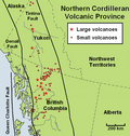
southeast of the cone then flowed southwest into a river valley. The Cassiar Mountains and Tanzilla Plateau in northern British Columbia are dominated...
63 KB (7,063 words) - 21:48, 4 August 2024

The Marble Range is a small mountain range adjoining the Fraser River on the southwestern edge of the Interior Plateau of British Columbia. It has an...
1 KB (103 words) - 19:00, 9 April 2024

Canada, located between the Sheslay River and Tuya River on the west and east and the Nahlin River and the Stikine River to the north and south. It is a subplateau...
3 KB (118 words) - 18:41, 9 April 2024