
from Baffin Island (to the south). To the east, it opens into Baffin Bay via Pond Inlet, and to the north-west into the Navy Board Inlet. "Tasiujaq". Geographical...
2 KB (83 words) - 20:06, 15 March 2023
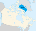
Baffin Bay (Inuktitut: Saknirutiak Imanga; Greenlandic: Avannaata Imaa; French: Baie de Baffin), located between Baffin Island and the west coast of Greenland...
22 KB (2,420 words) - 01:27, 9 June 2024

James Bay (French: Baie James; Cree: ᐐᓂᐯᒄ, romanized: Wînipekw, lit. 'dirty water') is a large body of water located on the southern end of Hudson Bay in...
17 KB (2,050 words) - 18:01, 21 June 2024
from Baffin Island. Although not geographically apparent, it is considered to be a marginal sea of the Arctic Ocean for climatic reasons. The bay is roughly...
5 KB (551 words) - 20:14, 9 May 2024
Tasiujaq (Inuktitut syllabics: ᑕᓯᐅᔭᖅ) formerly Murray Maxwell Bay is an uninhabited waterway in the Qikiqtaaluk Region, Nunavut, Canada. It is located...
2 KB (178 words) - 16:33, 11 September 2023
between 1845 and 1848. The bay has the same name as HMS Terror, one of the two ships of the expedition. The ships entered Baffin Bay in 1845 on their quest...
5 KB (501 words) - 01:30, 9 June 2024
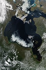
Hudson Bay, sometimes called Hudson's Bay (usually historically), is a large body of saltwater in northeastern Canada with a surface area of 1,230,000 km2...
55 KB (6,262 words) - 18:11, 31 May 2024
Sound in Baffin Island's east coast Desolation Sound between the Discovery Islands and the coast of British Columbia Tasiujaq between Baffin Island and...
12 KB (1,305 words) - 10:26, 13 July 2024

Frobisher Bay is an inlet of the Davis Strait in the Qikiqtaaluk Region of Nunavut, Canada. It is located in the southeastern corner of Baffin Island. Its...
7 KB (729 words) - 21:50, 7 June 2024
Paquet Bay is an Arctic waterway in Qikiqtaaluk Region, Nunavut, Canada. Located at Baffin Island's Borden Peninsula, Paquet Bay is situated between Tay...
817 bytes (37 words) - 03:31, 30 June 2019
Wager Bay or Ukkusiksalik Bay is long narrow inlet in the Kivalliq Region of Nunavut, Canada, which opens east into Roes Welcome Sound at the northwest...
4 KB (306 words) - 18:41, 23 June 2024
Wilmot and Crampton Bay is an Arctic waterway in the Kitikmeot Region, Nunavut, Canada . It is located on the eastern edge of Queen Maud Gulf, running...
3 KB (314 words) - 18:10, 23 May 2024

Pond Inlet (category Inlets of Baffin Island)
between Bylot Island and Baffin Island are Navy Board Inlet , which opens into Lancaster Sound and Tasiujaq, which opens to Baffin Bay. Navy Board Inlet is...
82 KB (8,683 words) - 16:23, 3 June 2024

Leaf River (Quebec) (category Hudson's Bay Company trading posts)
Peninsula into Leaf Bay off Ungava Bay over a distance of 480 kilometres (300 mi). At the head of Leaf Bay is the Inuit community of Tasiujaq. With caution...
10 KB (736 words) - 19:32, 20 September 2023
Augusta Bay is a bay of the Ellesmere Island, Nunavut, Canada. Meltwater from the Prince of Wales Icefield channels into the bay with its mouth opening...
1 KB (63 words) - 21:43, 30 May 2024
Bernier Bay is an Arctic waterway in the Qikiqtaaluk Region, Nunavut, Canada. It is located in the Gulf of Boothia, on the western edge of Baffin Island...
1 KB (85 words) - 14:34, 10 July 2024
M'Clure Bay (variant: McClure Bay) is a Peel Soundmap waterway in Qikiqtaaluk Region, Nunavut, Canada. It is located on the western side of Somerset Island...
2 KB (159 words) - 14:59, 8 November 2020
Lancaster Sound (category Bodies of water of Baffin Island)
Island and Baffin Island, forming the eastern entrance to the Parry Channel and the Northwest Passage. East of the sound lies Baffin Bay; to the west...
14 KB (1,369 words) - 17:23, 1 February 2024

Smith Sound (redirect from Sir Thomas Smith's Bay)
Greenland and Nunavut's northernmost island, Ellesmere Island. It links Baffin Bay with Kane Basin and forms part of the Nares Strait. On the Canadian side...
4 KB (391 words) - 19:49, 25 September 2023
Cameron Bay is an Arctic waterway in the Qikiqtaaluk Region, Nunavut, Canada. Located off northeastern Cameron Island, the bay is an arm of the Arctic...
1 KB (60 words) - 21:49, 16 June 2024

on the northern shore of the bay with Resolute Bay Airportmap to the northwest. The Inuit associated with Resolute Bay are called Qausuittuq and the...
7 KB (542 words) - 16:43, 4 June 2024
Aston Bay is an Arctic waterway in the Qikiqtaaluk Region of Nunavut, Canada. It is an arm of Peel Sound and is located on the western side of Somerset...
2 KB (155 words) - 21:33, 30 May 2024
Rutherford Bay is an Arctic waterway in Qikiqtaaluk Region, Nunavut, Canada. It is located at the north end of Rice Strait, near the southern entrance...
1 KB (66 words) - 12:39, 25 November 2023
Irene Bay is an Arctic waterway in Qikiqtaaluk Region. Nunavut, Canada. It is located in Eureka Sound by western Ellesmere Island. The Sverdrup Pass,...
2 KB (132 words) - 19:05, 18 November 2023
side of Sir William Parker Strait. Other bays in the area include Purcell Bay and Dampier Bay. "Shamrock Bay". travelingluck. Retrieved 2009-08-30. v...
987 bytes (49 words) - 12:40, 25 November 2023
Herschel Bay is an Arctic waterway in the Qikiqtaaluk Region, Nunavut, Canada. It is located in Nares Strait, west of Smith Sound. Ellesmere Island is...
1 KB (71 words) - 11:45, 11 February 2024
Woodward Bay is an Arctic waterway in Qikiqtaaluk Region, Nunavut, Canada. It is located in Nares Strait, off eastern Ellesmere Island. Copes Bay is 12.2 km...
1 KB (57 words) - 19:04, 18 November 2023
Imiliit (category Islands of Baffin Island)
Qikiqtaaluk Region, Nunavut. Located in Tasiujaq at the mouth of Milne Inlet, it is an irregularly shaped island off the Baffin Island coast. Another, smaller...
2 KB (64 words) - 08:34, 2 October 2023
Simpson Peninsula. Helen Island lies in the bay. Pelly Bay is named after Sir John Pelly, governor of the Hudson's Bay Company, that managed the British territory...
4 KB (295 words) - 15:28, 23 May 2024
Scoresby Bay is an Arctic waterway in Qikiqtaaluk Region, Nunavut, Canada. It is located in Nares Strait by eastern Ellesmere Island's Darling Peninsula...
1 KB (78 words) - 02:46, 2 November 2023