Tatatila is a municipality located in the mountainous central zone of the Mexican state of Veracruz, about 26 km from the state capital Xalapa. It has...
6 KB (282 words) - 08:59, 28 February 2024

Altotonga is delimited to the east by Misantla, to the south by Tenochtitlán, Tatatila, Las Minas, Villa Aldama and Perote, to the west by Jalacingo, and to the...
7 KB (170 words) - 00:50, 5 August 2024
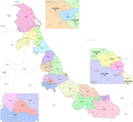
Reyes, Jilotepec, Las Minas, Las Vigas de Ramírez, Perote, Rafael Lucio, Tatatila, Teocelo, Tlacolulan, Tlalnelhuayocan, Villa Aldama and Xico. The district's...
18 KB (1,030 words) - 23:03, 28 July 2024

14,297 +5.2% 295.0 113.9 51.0/km2 (132.1/sq mi) March 19, 1997 156 Tatatila Tatatila 6,041 5,584 +8.2% 91.9 35.5 65.7/km2 (170.3/sq mi) December 1, 1868...
82 KB (1,134 words) - 15:41, 16 July 2024
900 ft). It borders the municipalities of Altotonga to the west and north, Tatatila to the east, Las Vigas de Ramírez to the south, and Villa Aldama to the...
14 KB (724 words) - 23:23, 26 December 2023
Juchique, Landero y Coss, Miahuatlán, Las Minas, Misantla, Nautla, Perote, Tatatila, Tenochtitlán, Tlacolulan, Tonavan, Vega de Alatorre, Vigas de Ramírez...
16 KB (935 words) - 21:44, 28 July 2024