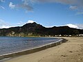
Taupō Bay is a bay, village and rural community in the Far North District and Northland Region of New Zealand's North Island. There are about 40 permanent...
5 KB (442 words) - 09:49, 4 October 2024

Taupō (Māori pronunciation: [ˈtaʉpɔː]), sometimes written Taupo, is a town located in the central North Island of New Zealand. It is situated on the edge...
32 KB (2,773 words) - 06:05, 4 October 2024

Island, located in the caldera of Taupō Volcano. The lake is the namesake of the town of Taupō, which sits on a bay in the lake's northeastern shore....
18 KB (1,746 words) - 15:55, 21 August 2024

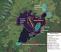
Lake Taupō, in the centre of New Zealand's North Island, fills the caldera of the Taupō Volcano, a large rhyolitic supervolcano. This huge volcano has...
53 KB (4,816 words) - 01:34, 12 October 2024
(0.31 in) per year at Taupō. The zone is named after Lake Taupō, the flooded caldera of the largest volcano in the zone, the Taupō Volcano and contains...
108 KB (6,918 words) - 01:35, 12 October 2024

population is largely located in the two main centres, Taupō and Tūrangi. The district is governed by Taupō District Council. The vast majority of the district...
16 KB (956 words) - 03:13, 11 October 2024

Pukawa (redirect from Lake Taupo Bays)
Pukawa or Pukawa Bay (Māori: Pūkawa) is a bay and a small township on the southern shores of Lake Taupō on New Zealand's North Island. It is off State...
10 KB (1,014 words) - 06:58, 4 October 2024
or Taupo may also refer to: Lake Taupō, the lake that the town of Taupō sits on Taupō Bay, a bay on Lake Taupō Taupō Volcano, a volcano in the centre...
962 bytes (179 words) - 08:08, 10 December 2022
Pukaretu Reserve Mangakino Hawks (Mangakino) - Mangakino Sports Fields Taupō Phoenix (Taupō) - Hickling Park Te Paamu/TePuke Tigers (Te Puke) - Pakowhai Park...
6 KB (287 words) - 22:38, 29 July 2024
Pākā Bay, formerly called Halletts Bay is a bay on the eastern shore of Lake Taupō, New Zealand, about 27km south-east of Taupō township. It was known...
3 KB (407 words) - 11:51, 31 August 2022

Tauranga Taupō is a semi-rural area located at the mouth of Tauranga Taupō River, on the southern shores of Lake Taupō in New Zealand's North Island....
10 KB (930 words) - 09:49, 4 October 2024

Hazlehurst Craig Little Hawke's Bay is covered by five general electorates — namely Napier, Tukituki, Wairarapa, Rangitīkei, and Taupō. The bulk of the region...
52 KB (4,745 words) - 08:38, 9 October 2024

The Taupō Rift is the seismically active rift valley containing the Taupō Volcanic Zone, central North Island of New Zealand. The Taupō Rift (Taupo Rift)...
19 KB (1,562 words) - 01:53, 26 August 2024

District and the town of Rangitaiki in Taupō District. Public health in New Zealand is broken into regions. The Bay of Plenty and Lakes district health boards...
33 KB (3,038 words) - 21:15, 17 October 2024

Tokaanu (category Taupō District)
close to Tūrangi at the southern end of Lake Taupō. The Tokaanu Thermal Pools and the easy access to Lake Taupo make it a popular lakeside holiday destination...
3 KB (284 words) - 09:15, 9 March 2024
Taupō District Council is a territorial authority that administers the Taupō District in the Central North Island of New Zealand. The district stretches...
5 KB (606 words) - 19:31, 10 July 2024

Acacia Bay is a suburb of Taupō, on the western edge of Tapuaeharuru Bay Lake Taupō in New Zealand. There are four main beach areas. It is located approximately...
8 KB (895 words) - 07:05, 4 October 2024
The Tauranga Taupō River is a river of the Hawke's Bay and Waikato Regions of New Zealand's North Island. It flows northwest from its sources at the northern...
1 KB (84 words) - 21:39, 14 July 2024

2011 Christchurch earthquake and the M 7.3 aftershock to the 1931 Hawke's Bay earthquake. Earthquakes occur frequently in New Zealand as the country is...
66 KB (2,793 words) - 23:08, 13 October 2024
Oruanui eruption (category Taupō Volcanic Zone)
than at present and the Taupō Volcano had been for over 100,000 years mainly located under a larger lake than the present Lake Taupō called Lake Huka.: 6 ...
27 KB (2,692 words) - 01:12, 7 October 2024

(Manawatū-Whanganui: 98.42%; Wellington: 1.58%) Taupō District (Waikato: 73.74%; Bay of Plenty: 14.31%; Hawke's Bay: 11.26%; Manawatū-Whanganui: 0.69%) Waitomo...
6 KB (501 words) - 08:06, 22 July 2024

Māori and Europeans happened out in the bay. It did not go well. 2km 1.2miles Wainui Inlet Whariwharangi Bay Taupō Point Uarau Point Wainui is a Māori...
13 KB (1,333 words) - 04:31, 20 July 2024

Rotorua (redirect from Rotorua, Bay of Plenty)
Auckland. To the south, State Highway 5 provides the main route from Taupō, Hawke's Bay, Manawatu, and Wellington. State Highway 30 runs southwest to northeast...
67 KB (5,815 words) - 09:12, 7 October 2024

Ngāti Tūwharetoa invasion of Taupō was a conflict which took place in the sixteenth century on the east coast of Lake Taupō in the central North Island...
14 KB (1,764 words) - 07:08, 12 April 2024

Hāpeta, Ngāti Kaitangata and Ngāti Rua, based at Taupō Marae and Te Tiriti meeting house at Taupō Bay. Waimahana, Riwhi and Te Pania are affiliated with...
3 KB (304 words) - 09:32, 16 December 2022

Rotorua-Taupō thermal area to the upper reaches of the Waikato River. SH 5 joins SH 1 at Wairakei, a few kilometres north of the town of Taupō, and runs...
8 KB (632 words) - 19:58, 25 August 2024

Hatepe eruption (category Taupō Volcanic Zone)
sometimes referred to as the Taupō eruption or Horomatangi Reef Unit Y eruption, is dated to 232 CE ± 10 and was Taupō Volcano's most recent major eruption...
22 KB (2,206 words) - 07:26, 11 September 2024

Whakaari / White Island (redirect from White Island (Bay of Plenty))
of Bay of Plenty as much as 7 kilometres (4.3 mi) inland between 3,000 and 2,200 B.P. Whakaari / White Island lies in the northern end of the Taupō Volcanic...
41 KB (4,553 words) - 18:45, 8 October 2024

travellers followed the Taua Tapu track through Taupō to Pukerua Bay. So Pāuatahanui grew at the expense of Taupō until the railway line was opened in 1885...
18 KB (2,076 words) - 06:12, 4 October 2024

Taupō Central is the central suburb and business district of Taupō in the Waikato region of New Zealand's North Island. An eight-storey hotel was proposed...
12 KB (835 words) - 09:50, 4 October 2024