
Taymyr Strait (Russian: Таймырский пролив) is a 3 km-wide strait in Russia. It separates Taymyr Island from Taymyr Peninsula, and connects the Palander...
638 bytes (56 words) - 15:24, 3 August 2022

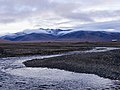
The Taymyr Peninsula (Russian: Таймырский полуостров, romanized: Taymyrsky poluostrov) is a peninsula in the Far North of Russia, in the Siberian Federal...
10 KB (850 words) - 13:22, 23 August 2024
located west of the Taymyr Gulf in an area of skerries right off the western coast of the Taymyr Peninsula. The narrow strait between Taymyr island and the...
4 KB (372 words) - 21:58, 10 November 2023
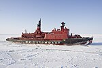
Nuclear-powered icebreaker (redirect from Taymyr class nuclear icebreaker)
Design Bureau "Iceberg" began designing a replacement for the Arktika- and Taymyr classes. The program called for a series of icebreaker designs ranging from...
18 KB (1,804 words) - 15:49, 20 May 2024

Russian high Arctic. It lies off Siberia's Taymyr Peninsula, separated from the mainland by the Vilkitsky Strait. This archipelago separates two marginal...
49 KB (4,909 words) - 03:50, 14 August 2024

entrance to the Vilkitsky Strait from the east, and the Firnley Islands do so from the west. The shores on the side of the Taymyr Peninsula are covered with...
2 KB (164 words) - 08:14, 14 May 2024

107°15′E / 78.117°N 107.250°E / 78.117; 107.250. The Vilkitsky Strait runs south of Maly Taymyr Island and its waters, as well as the waters surrounding the...
4 KB (305 words) - 05:04, 16 April 2024

Red Army Strait (Russian: Пролив Красной Армии, Proliv Krasnoy Army) is a strait in Severnaya Zemlya, Russia. It is named after the Red Army (Krasnaya...
3 KB (203 words) - 18:37, 9 January 2022

The First Soviet Convoy to the Mouth of the Lena. Khatanga settlement & Taymyr area information and pictures: [1] Archived 2008-04-13 at the Wayback Machine...
3 KB (290 words) - 03:11, 15 June 2024

Northwest Passage (section Strait of Anián)
Wales Strait on the northwest side of Victoria Island. M'Clure Strait to the northwest is ice-filled; southwest through the Prince of Wales Strait between...
126 KB (13,506 words) - 13:47, 24 August 2024

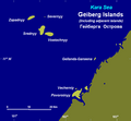
archipelago, consisting of the islands located south of the Matisen Strait near and around Taymyr Island. Kolchak Island, located further south, is not geographically...
15 KB (1,563 words) - 06:00, 23 August 2024
18 mi) north of the west coast of the Taymyr Peninsula. On 23 August more ships were seen in the Vilkitsky Strait, between the Taimyr Peninsula and Bolshevik...
35 KB (4,890 words) - 23:28, 29 June 2024

their crews, a total of 129 officers and men, became icebound in Victoria Strait near King William Island in what is today the Canadian territory of Nunavut...
124 KB (13,817 words) - 17:53, 22 August 2024

that now bears his name (Vilkitsky Island), as well as the islands of Maly Taymyr and neighboring Starokadomsky. In 1914–1915, Vilkitsky's expedition made...
5 KB (408 words) - 21:48, 12 July 2024

North America, and the borders follow topographic features: the Bering Strait on the Pacific side and the Greenland Scotland Ridge on the Atlantic side...
65 KB (6,990 words) - 15:08, 12 August 2024

the Svalbard archipelago, Franz Josef Land and Severnaya Zemlya to the Taymyr Peninsula. It is situated south of the underwater ridge Gakkel Ridge roughly...
9 KB (865 words) - 15:39, 4 August 2024

Ostrov Lishniy off its northern tip. The group formed by the smaller Maly Taymyr and Starokadomsky islands is located further offshore off the southeastern...
7 KB (578 words) - 03:55, 12 August 2024
of the Russian Hydrographic Service, but he was unaware that there was a strait west of the cape between what is now Bolshevik Island and the islands further...
5 KB (361 words) - 13:33, 13 November 2023
Yuny Strait (Russian: Юный пролив) is a strait in Severnaya Zemlya, Russia. It is covered with ice most of the year. Initially named Proliv Yungshturm...
3 KB (154 words) - 19:03, 9 January 2022

Shokalsky Strait (Russian: Пролив Шокальского) is a strait in Severnaya Zemlya, Russia. The Shokalsky Strait is an up to a 50 km-wide strait that separates...
3 KB (168 words) - 18:49, 9 January 2022

expedition explores the mouth of the Yenisey River and the coast of the Taymyr Peninsula 1712: Merkury Vagin and Yakov Permyakov explore the vicinity of...
40 KB (4,647 words) - 10:28, 22 April 2024
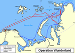
Vladivostok and Pevek in the east. The areas around the Taymyr Peninsula, including the Vilkitsky Strait, see next to no shipping at all. The polar station...
5 KB (568 words) - 05:20, 23 July 2024
with a relatively flat relief separating the Byrranga Mountains of the Taymyr Peninsula in the north from the Central Siberian Plateau in the south. Area...
6 KB (496 words) - 00:35, 18 July 2024

east, from Karelia and the Kola Peninsula to Nenetsia, the Gulf of Ob, the Taymyr Peninsula and the Chukchi Peninsula (Kolyma, Anadyr River, Cape Dezhnev)...
50 KB (5,587 words) - 16:06, 12 August 2024

and the northern coast of the Canadian mainland. In 2014, the Victoria Strait Expedition found two items on Hat Island, in the Queen Maud Gulf, near King...
17 KB (1,726 words) - 09:38, 11 August 2024

George Back (section Frozen Strait Expedition)
He reached Hudson Strait on the first of August. By the end of the month, Terror was beset by ice somewhere east of Frozen Strait. It remained icebound...
15 KB (1,885 words) - 23:24, 22 August 2024
Russian Arctic Ocean Hydrographic Expedition on icebreakers Vaygach and Taymyr under Boris Vilkitsky, landed on the island. In 1916 the Tsarist government...
60 KB (6,279 words) - 09:11, 12 August 2024

to the mouth of the Yenisei and east to the mouth of the Pyasina on the Taymyr Peninsula. 1610 – A detachment from Mangazeya ascends the Yenisei a further...
108 KB (10,893 words) - 01:45, 20 August 2024

the boundary between the Barents and Kara Seas (the Kara Strait) and ends in the Bering Strait (Cape Dezhnev). The NSR straddles the seas of the Arctic...
42 KB (4,516 words) - 22:35, 16 August 2024

Zaliv Faddeya) is a gulf in the Laptev Sea on the eastern coast of the Taymyr Peninsula. It measures about 47 km from its innermost point in the southwest...
2 KB (217 words) - 16:05, 20 August 2024