
Terminous is a census-designated place in San Joaquin County, California. Terminous sits at an elevation of 7 feet (2.1 m) below sea level. It is located...
6 KB (517 words) - 05:41, 14 July 2023
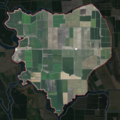
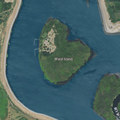
The Terminous Tract is an island in the Sacramento–San Joaquin River Delta. It is part of San Joaquin County, California, and managed by Reclamation District...
12 KB (559 words) - 00:53, 9 August 2023
The following is a list of California locations by income. California had a per capita income of $29,906 during the five-year period comprising years 2010...
224 KB (929 words) - 09:59, 22 December 2024
Kennedy Lincoln Village Linden Lockeford Morada Peters Taft Mosswood Terminous Thornton Victor Waterloo Woodbridge Atlanta Banta Clements Mormon Vernalis...
81 KB (4,408 words) - 02:36, 26 February 2025

Angeles. April 21, 2022 – A brief EFU tornado occurred east-northeast of Terminous in San Joaquin County. August 28, 2022 – A nearly stationary EFU tornado...
298 KB (26,067 words) - 21:46, 5 April 2025

part of the California Freeway and Expressway System, and from I-280 to the eastern Fremont city limits and from the southern terminous of Isabel Avenue...
24 KB (1,826 words) - 16:06, 24 April 2025
Ripon, and Escalon; and the census-designated places Mountain House, Terminous, Thornton, Collierville, Woodbridge, Acampo, Dogtown, Lockeford, Victor...
82 KB (983 words) - 18:21, 16 April 2025
The following is a list of California locations by race. According to 2010 data from the U.S. Census Bureau, people of White ancestry were the dominant...
236 KB (1,182 words) - 04:18, 31 March 2025
(primary coordinates) GPX (secondary coordinates) This list of islands of California is organized into sections, generally arranged from north to south. The...
57 KB (846 words) - 23:07, 19 March 2025

Sacramento–San Joaquin River Delta (redirect from California Delta)
Sacramento–San Joaquin River Delta, or California Delta, is an expansive inland river delta and estuary in Northern California. The delta is formed at the western...
66 KB (7,397 words) - 01:11, 15 January 2025
Lodi Unified School District (category School districts in San Joaquin County, California)
the following San Joaquin County communities: Lodi, Acampo, Lockeford, Terminous, Victor, and Woodbridge, as well as portions of northern Stockton, most...
5 KB (357 words) - 03:18, 15 February 2025
24 February 2021. United States Geological Survey (1952). "Terminous Quadrangle, California" (Map). United States Department of the Interior Geological...
4 KB (155 words) - 09:32, 18 February 2022
Suisun Bay (redirect from Suisun Bay, California)
estuary (a northeastern extension of the San Francisco Bay) in Northern California. It lies at the confluence of the Sacramento River and San Joaquin River...
6 KB (524 words) - 00:54, 13 March 2025
communities counties, and other recognized places in the U.S. state of California. Information on the number and names of counties in which the place lies...
27 KB (77 words) - 00:01, 15 January 2025

Plains and Sierra Miwok (category Indigenous peoples of California)
Gualacomne at Freeport on both sides of the Sacramento River Guaypemne at Terminous on the Mokelumne River delta Lelamne at Clements on the Mokelumne River...
19 KB (2,080 words) - 22:40, 1 April 2025
1947-03-15. p. 4. United States Geological Survey (1952). "Terminous Quadrangle, California" (Map). United States Department of the Interior Geological...
4 KB (178 words) - 10:50, 24 February 2022

National Register of Historic Places listings in San Joaquin County, California. This is intended to be a complete list of the properties and districts...
14 KB (300 words) - 08:26, 4 March 2025

Shin Kee Tract (category Islands of San Joaquin County, California)
California. 1984-08-12. p. 2. "Terminous Tract Deed Is Signed In China". Stockton Daily Evening Record. Stockton, California. 1918-06-07. p. 5. "Municipal...
5 KB (221 words) - 10:50, 24 February 2022

miles (64 km) through the Sacramento–San Joaquin River Delta in Northern California. The Old River was once the main channel of the San Joaquin until navigation...
8 KB (739 words) - 15:39, 27 February 2022

the Interstate Highway System serve Honolulu: Interstate H-1, western terminous is at Kapolei where you can connect to the Farrington Highway. The H-1...
91 KB (8,007 words) - 13:44, 21 April 2025
San Joaquin and Sierra Nevada Railroad (category Defunct California railroads)
Tract on the east side of South Mokelumne River, between Hog Slough and Terminous) to Woodbridge and Lodi and then east to the Sierra Nevada foothill town...
6 KB (770 words) - 19:45, 8 February 2025
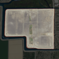
Atlas Tract (category Islands of San Joaquin County, California)
California. 1967-12-01. p. 19. Retrieved 2021-11-17 – via Newspapers.com. United States Geological Survey (1978). "Terminous Quadrangle, California"...
11 KB (786 words) - 20:39, 20 November 2023

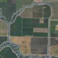
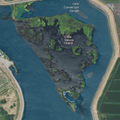
Empire Tract (category Islands of Northern California)
Survey measured its elevation as −10 ft (−3.0 m) in 1981. To the north is Terminous Tract (across White Slough), and to the northwest is Bouldin Island (across...
23 KB (1,757 words) - 13:01, 31 August 2024
Grizzly Bay (category Bays of California)
Francisco Bay, and an extension of Suisun Bay, which dips into Solano County, California. Grizzly Bay contains many sloughs, wildlife areas, and islands such as...
1 KB (92 words) - 02:59, 28 April 2022

Rio Blanco Tract (category Islands of San Joaquin County, California)
Modesto Bee. Modesto, California. 1982-12-01. p. 2. United States Geological Survey (1952). "Terminous Quadrangle, California" (Map). United States Department...
5 KB (220 words) - 10:50, 24 February 2022

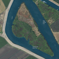
Hog Island (San Joaquin County) (category Islands of San Joaquin County, California)
6 September 2021. United States Geological Survey (1952). "Terminous Quadrangle, California" (Map). United States Department of the Interior Geological...
14 KB (1,087 words) - 18:22, 17 August 2024
Little Venice Island (category Islands of San Joaquin County, California)
Sacramento Bee. Sacramento, California. 2002-11-28. p. 38. United States Geological Survey (1952). "Terminous Quadrangle, California" (Map). United States Department...
4 KB (173 words) - 10:49, 24 February 2022

Tinsley Island (category Islands of San Joaquin County, California)
24 February 2021. United States Geological Survey (1952). "Terminous Quadrangle, California" (Map). United States Department of the Interior Geological...
26 KB (1,899 words) - 09:22, 12 June 2024
Spud Island (category Islands of San Joaquin County, California)
System: Spud Island United States Geological Survey (1952). "Terminous Quadrangle, California" (Map). United States Department of the Interior Geological...
11 KB (950 words) - 10:49, 24 February 2022

Howell Mountains (category California Coast Ranges)
same areas, particularly around Sulphur Springs Mountain at the southern terminous, cinnabar deposits were mined in the late 1800s for quicksilver. The west...
10 KB (1,271 words) - 01:32, 2 August 2024