
The Bentway, formerly Project: Under Gardiner, is a public trail and corridor space underneath the Gardiner Expressway in Toronto, Ontario, Canada. It...
10 KB (925 words) - 04:05, 7 May 2024

Gardiner Expressway (redirect from The Gardiner Expressway)
was built underneath the Gardiner, between Strachan and Spadina Avenue. Named after the Gardiner's main supports (bents), The Bentway uses bents to create...
105 KB (12,475 words) - 04:16, 3 September 2024
The Iron Horse Trail is a rail trail located in east-central Alberta in Canada. The 300 km-long, multiuse recreational trail is used by all-terrain vehicles...
1 KB (119 words) - 00:18, 22 April 2022

International Appalachian Trail (category Long-distance trails in the United States)
to the Gaspé Peninsula of Quebec, after which it followed a ferry route to Newfoundland, and then continued to the northern-easternmost point of the Appalachian...
8 KB (798 words) - 14:33, 16 October 2024

formation resembling a crack in the mountain filled with boulders, and the panoramic views of the mountains and lakes at the peak. The trail starts off at relatively...
7 KB (634 words) - 14:57, 4 April 2024

Toronto Music Garden (category Pages using the Kartographer extension)
park in Toronto, Ontario, Canada. "Toronto Music Garden is the serene Bach inspired park by the waterfront". www.blogto.com. Retrieved 2023-11-14. "Toronto...
2 KB (75 words) - 03:07, 15 November 2023

Toronto Islands (redirect from History of the Toronto Islands)
The Toronto Islands are a chain of 15 islands in Lake Ontario, south of mainland Toronto, Ontario, Canada. Comprising the only group of islands in the...
68 KB (7,654 words) - 08:18, 12 October 2024

Scarborough Bluffs (redirect from The Bluffs)
The Scarborough Bluffs, also known as The Bluffs, is an escarpment in the Scarborough district of Toronto, Ontario, Canada. There are nine parks along...
13 KB (1,633 words) - 22:07, 19 June 2024
Canada, bordered by Queen Street West on the south and Dundas Street on the north. The western boundary of the park is Crawford Street, several hundred...
13 KB (1,508 words) - 22:14, 25 September 2024

High Line (redirect from The High Line)
projects in the network, including River LA, the Atlanta Beltline, Crissy Field, Dequindre Cut, the Lowline, Klyde Warren Park, the Bentway, Bergen Arches...
124 KB (10,958 words) - 18:28, 16 October 2024

Bruce Trail (category Protected areas of the Regional Municipality of Peel)
The Bruce Trail is a hiking trail in southern Ontario, Canada, from the Niagara River to the tip of Tobermory, Ontario. The main trail is more than 890 km...
16 KB (1,724 words) - 17:36, 8 August 2024

spanning the Lower Don River in Toronto, Ontario, Canada, between Cabbagetown to the west and Broadview Avenue in Riverdale to the east. The park has...
7 KB (767 words) - 23:20, 18 July 2024

Hanlan's Point Beach (category Pages using the Kartographer extension)
the western side of the Toronto Islands in Toronto, Ontario on the shore of Lake Ontario. Hanlan's is recognized by the City of Toronto as one of the...
11 KB (1,278 words) - 16:23, 23 September 2024

West Coast Trail (category Shipwrecks of the British Columbia coast)
to facilitate the rescue of shipwrecked survivors along the coast, part of the treacherous Graveyard of the Pacific. It is now part of the Pacific Rim National...
25 KB (2,860 words) - 15:43, 25 August 2024

Nathan Phillips Square (category Venues of the 2015 Parapan American Games)
also utilized the parking garage located underneath the square. The square is rectangular in shape, with the edge of the city hall meeting the square on an...
22 KB (2,532 words) - 17:26, 30 June 2024
not-Work". AKA. Retrieved 2023-11-22. ""First Winter" Programming at The Bentway". The Bentway. Retrieved 4 July 2023. "Attention, Toronto artists. Local landmarks...
8 KB (655 words) - 05:58, 22 November 2023

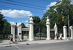
Queen's Park (Toronto) (category Pages using the Kartographer extension)
of Queen Victoria. The park is the site of the Ontario Legislative Building, which houses the Legislative Assembly of Ontario. The phrase "Queen's Park"...
30 KB (2,927 words) - 21:19, 7 September 2024

Toronto ravine system (section Portrayal in the arts)
forest that runs through most of Toronto. The ravine system is the largest in any city in the world, with the Ravine and Natural Feature Protection Bylaw...
46 KB (5,312 words) - 20:10, 8 October 2024
The following is a list of the parks in the city of Toronto, Ontario, Canada. The appearance of Toronto's ravines was altered by floods caused by Hurricane...
29 KB (2,499 words) - 00:54, 11 October 2024
Canol Heritage Trail (category Hiking trails in the Northwest Territories)
Canada. The trail is in the process of becoming a territorial park. The trail follows the route of the Canol Road lying within the Northwest Territories...
11 KB (1,236 words) - 14:10, 25 December 2023

Roundhouse Park (category Pages using the Kartographer extension)
Street. The John Street Roundhouse was built in 1929–1931 and renovated in the 1990s. In 1997, the area to the east of the building became the city-owned...
15 KB (1,390 words) - 03:28, 29 August 2024

Yonge–Dundas Square, or Dundas Square is a public square at the southeast corner of the intersection of Yonge Street and Dundas Street East in Downtown...
29 KB (3,251 words) - 19:24, 9 October 2024

Trans Canada Trail (redirect from Relay 2000 of the Trans Canada Trail)
that stretches from the Atlantic to the Pacific to the Arctic oceans. The trail extends over 24,000 km (15,000 mi); it is now the longest recreational...
41 KB (4,159 words) - 23:22, 28 August 2024

High Park (section Friends of the Park)
Pond and on the east by Parkside Drive. The landscape in the park is hilly, with two deep ravines extending the full north–south distance of the park. Significant...
65 KB (6,830 words) - 12:48, 9 October 2024

Ontario Place and Exhibition Place to Harbourfront Centre and the CN Tower. The Bentway offers year-round activities and events, including gardens, a...
8 KB (713 words) - 10:00, 26 April 2024
The Parc Linéaire Le P'tit Train du Nord is a multiuse recreational rail trail located in Quebec, Canada. It runs through the Rivière du Nord valley....
3 KB (285 words) - 05:12, 21 May 2024

Christie Pits (category Pages using the Kartographer extension)
under the park, converted to a storm sewer at the turn of the 20th century. The park was named after the Christie Sand Pits which were on the location...
9 KB (970 words) - 21:57, 21 December 2023

Guild Park and Gardens (section The "Greek" Theatre)
Park and Gardens is a public park in the Scarborough district of Toronto, Ontario, Canada. The park was formerly the site of an artist colony and is notable...
16 KB (1,910 words) - 03:58, 8 August 2024

Simcoe Park (category Pages using the Kartographer extension)
Park is a park in Toronto, Ontario, Canada. The Worker's Monument (or 100 Workers Monument) is installed in the park. Simcoe Park was used by Occupy Toronto...
2 KB (94 words) - 23:35, 19 September 2024

Kingston. In Ottawa the trail ends at the foot of the Rideau Canal Ottawa Locks on the Ottawa River, within sight of Parliament Hill. The main trail is marked...
4 KB (390 words) - 18:13, 21 May 2022