
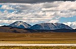
Toconce is a small Chilean village located on the south rim of the Toconce River Canyon at 3,350 m above sea level. To the north, the landscape is dominated...
772 bytes (77 words) - 22:52, 30 March 2021
The Toconce River is a river of Chile. List of rivers of Chile EVALUACION DE LOS RECURSOS HIDRICOS SUPERFICIALES EN LA CUENCA DEL RIO BIO BIO[permanent...
940 bytes (35 words) - 12:10, 31 March 2020

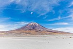
Toconce is a volcano in Chile. Toconce volcano has a central crater and is constructed mainly by andesitic lava flows, which were emplaced during three...
6 KB (614 words) - 15:20, 9 March 2024

commune also encompasses the Quechua communities of Estación San Pedro, Toconce and Cupo; and the Lickan-antay communities of Taira, Conchi Viejo, Lasana...
19 KB (1,447 words) - 00:36, 18 July 2024

El Loa Calama Calama Ayquina Caspana Lasana San Francisco de Chiu Chiu Toconce Ollagüe San Pedro de Atacama Socaire Toconao Tocopilla Tocopilla Tocopilla...
14 KB (1,253 words) - 23:15, 12 August 2024
"Ayquina and Toconce". Entry on the UNESCO Tentative List. Archived from the original on 24 July 2008. Retrieved 2008-07-02. Ayquina and Toconce - UNESCO...
2 KB (234 words) - 01:29, 26 December 2019
2013-11-10 at the Wayback Machine, retrieved on 10 November 2013 Cerro Toconce Archived 2013-11-10 at the Wayback Machine, retrieved on 10 November 2013...
39 KB (596 words) - 12:01, 17 January 2024

In traditional medicine in communities such as San Pedro de Atacama, Toconce, Socaire, and Ollagüe, rica-rica is used to treat indigestion, as an antispasmodic...
5 KB (526 words) - 03:40, 10 March 2024
Volcanic Zone and forms a volcanic lineament with neighbouring Paniri and Toconce that was active into the Holocene. Cerro del León itself was constructed...
7 KB (610 words) - 17:22, 13 November 2023

This chain is parallel to several Paleozoic faults in the region. The Rio Toconce, a tributary of the Rio Salado and ultimately of the Loa River, originates...
5 KB (500 words) - 08:31, 10 May 2023
from the original on 1 April 2016. Retrieved 7 October 2010. "Ayquina and Toconce". UNESCO World Heritage Centre. Retrieved 24 September 2017. "Baquedano...
32 KB (805 words) - 21:11, 4 September 2024
Comunidades en Red". www.comunidadesenred.cl. Retrieved 2021-07-11. "En Toconce, Minera El Abra y las comunidades del Alto El Loa analizaron el potencial...
5 KB (392 words) - 16:22, 20 December 2023

carved in volcanic rocks. In its middle course, the river receives the Toconce River (originated at the foot of Linzor volcano) from the north and the...
3 KB (262 words) - 11:13, 1 June 2024

northwest-striking normal fault zones which also affected the Luxsar and Toconce volcanoes. The range is partially underpinned by modern ignimbrites. Canapa...
3 KB (309 words) - 08:05, 30 January 2024

connects El Tatio to San Pedro de Atacama. Towns close to El Tatio are Toconce to the north, Caspana to the west and Machuca to the south. A workers'...
106 KB (12,355 words) - 22:20, 20 March 2024
Clavero, Jorge; Giavelli, Aldo. "Geología de la cadena volcánica Paniri-Toconce, Zona Volcánica Central, Altiplano de la Región de Antofagasta, Chile"...
4 KB (347 words) - 15:16, 9 March 2024

Juriques, Laguna Verde, Licancabur, Linzor, Paniri, Sairecabur, Tatio and Toconce. On its summit, four different ceremonial platforms are arranged in a cloverleaf...
18 KB (1,755 words) - 00:56, 7 December 2023
8779 149 Tirúa -38.34303 19 Tocadillo -32.65793 2994 Tocoihué -42.30778 7 Toconce -22.27943 3126 Todos Santos -19.00542 3912 Tolar -28.40241 2664 Toledo...
94 KB (145 words) - 00:34, 19 July 2022
Salado, Río Salado) Rio ToconceRío Toconce • 22°16′46″S 68°12′46″W / 22.27943°S 68.21281°W / -22.27943; -68.21281 (Río Toconce) • 3869720 • STMI...
14 KB (1,481 words) - 03:20, 8 March 2022
is made up by San Pedro, San Pablo, Paniri, Cerro Chao, Cerro de Leon, Toconce and Linzor. Paniri has erupted rocks ranging from basaltic andesite to...
15 KB (1,660 words) - 13:33, 9 March 2024

second with the Sifon and Vilama; the third with the Panizos, Coranzuli, Toconce, Pujsa, Guacha, Chuhuilla, Carcote and Alota; and the fourth with the Atana-Toconao...
40 KB (4,921 words) - 06:48, 16 August 2024

lineament, which includes San Pedro, Paniri, Cerro Chao, Cerro del León, Toconce and Linzor. Other volcanoes with such trends are Carasilla-Polapi-Cerro...
39 KB (4,642 words) - 11:17, 18 February 2024