
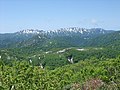
Tsugaru Quasi-National Park (津軽国定公園, Tsugaru Kokutei Kōen) is a quasi-national park in Aomori Prefecture in the far northern Tōhoku region of Honshū in...
4 KB (298 words) - 14:28, 31 March 2024
Shirakami-Sanchi (section Tsugaru Quasi-National Park)
Asiatic black bear Shirakami-Sanchi is bordered on the east by Tsugaru Quasi-National Park. Shirakami-dake is the highest peak in Shirakami-Sanchi. It is...
6 KB (752 words) - 09:29, 17 June 2024

Quasi-National Park Shimokita Hantō Quasi-National Park Tsugaru Quasi-National Park Hayachine Quasi-National Park Kurikoma Quasi-National Park Minami-Sanriku...
24 KB (1,169 words) - 03:39, 11 July 2024

mountain and its surroundings are located within the borders of Tsugaru Quasi-National Park. There are various theories about the origin of the name "Iwaki"...
9 KB (803 words) - 02:24, 18 August 2024

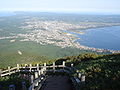
through the city. Parts of the city are within the borders of Tsugaru Quasi-National Park. Aomori Prefecture Ajigasawa Goshogawara Hirosaki Nakadomari...
11 KB (639 words) - 17:51, 3 October 2024
Authority of Japan. Retrieved 14 February 2020. 公園計画図~津軽国定公園~ 2-11 [Tsugaru Quasi-National Park Limits- Map 2-11] (PDF) (Map) (in Japanese). Retrieved 14 February...
3 KB (228 words) - 06:13, 21 August 2023

areas of the town are within the Tsugaru Quasi-National Park. The Akaishi Keiryū Anmon no Taki Prefectural Natural Park is also partly located within the...
15 KB (834 words) - 14:46, 7 October 2024

within the borders of the Tsugaru Quasi-National Park. Aomori Prefecture Aomori Imabetsu Itayanagi Nakadomari Sotogahama Tsugaru Tsuruta Yomogita The city...
16 KB (811 words) - 18:19, 3 October 2024

Kurosaki Rivers. Much of the town is within the limits of the Tsugaru Quasi-National Park. Aomori Prefecture Goshogawara Sotogahama The town has a cold...
13 KB (531 words) - 06:16, 19 July 2024

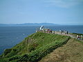
northernmost point of Tsugaru Peninsula, Honshu, in Sotogahama, Aomori Prefecture, Japan. It is located within the Tsugaru Quasi-National Park and on clear days...
2 KB (187 words) - 20:40, 7 November 2021

Heritage Site, and some coastal areas of the town are within the Tsugaru Quasi-National Park. The islets of Kyūroku-jima in the Sea of Japan are located within...
14 KB (578 words) - 14:45, 7 October 2024
Tsugaru Strait. Much of the town is within the limits of the Tsugaru Quasi-National Park. Most of the settlements and arable land are located along the...
14 KB (684 words) - 06:17, 19 July 2024

namely the Towada-Hachimantai and Sanriku Fukkō National Parks; Shimokita Hantō and Tsugaru Quasi-National Parks; and Asamushi-Natsudomari, Ashino Chishōgun...
97 KB (9,259 words) - 14:23, 26 September 2024

it is within the borders of the city of Mutsu and Shimokita Hanto Quasi-National Park. Lake Usori is located in the volcanic Osorezan Mountains, of which...
3 KB (258 words) - 10:00, 20 May 2024

Peninsula, and is part of the Shimokita Hantō Quasi-National Park. The cape is on the border of Tsugaru Strait separating Honshu from Hokkaido, and the...
2 KB (99 words) - 21:12, 2 May 2024
These two peninsulas face Tsugaru and Shimokita Peninsulas of Honshū across the Tsugaru Strait. The Ōnuma Quasi-National Park is located on the peninsula...
4 KB (424 words) - 19:18, 16 October 2024

Much of the village is within the borders of the Shimokita Hantō Quasi-National Park. Aomori Prefecture Mutsu Ōma The village has a cold oceanic climate...
9 KB (536 words) - 22:18, 11 August 2024

inlet to Mutsu Bay from the Tsugaru Strait. Much of the village is within the limits of the Shimokita Hantō Quasi-National Park. The mountainous area is...
10 KB (695 words) - 22:18, 11 August 2024

building was completed on March 19, 2005. National Route 101 Jūniko Lakes in the Tsugaru Quasi-National Park. List of Railway Stations in Japan Endo, Isao...
3 KB (242 words) - 23:41, 13 December 2022

Tsugaru Shirakami Prefectural Natural Park (津軽白神県立自然公園, Tsugaru Shirakami Kenritsu Shizen Kōen) is a Prefectural Natural Park in southwest Aomori Prefecture...
3 KB (186 words) - 06:13, 9 August 2023

Shimokita Peninsula, and is part of the Shimokita Hantō Quasi-National Park. The cape extends into the Tsugaru Strait separating Honshu from Hokkaido, which is...
3 KB (118 words) - 19:08, 1 May 2024

station on October 1, 1987. National Route 101 The rock formations of Senjōjiki Beach, part of the Tsugaru Quasi-National Park. List of Railway Stations...
3 KB (226 words) - 23:43, 13 December 2022


Geography of Hokkaido (section Parks)
(32,210.12 sq mi) which makes it the second-largest island of Japan. The Tsugaru Strait separates Hokkaidō from Honshu (Aomori Prefecture); La Pérouse Strait...
33 KB (1,388 words) - 20:19, 11 July 2024

Portions of the peninsula are within the borders of Shimokita Hantō Quasi-National Park, including Cape Ōma, the coastline of the village of Sai to the south...
6 KB (556 words) - 03:04, 29 July 2024

Chishōgun Prefectural Natural Park (芦野池沼群県立自然公園, Ashino Chishōgun kenritsu shizen-kōen) is a Prefectural Natural Park on the Tsugaru Peninsula in northwest Aomori...
2 KB (123 words) - 12:08, 27 December 2019


protected as part of Towada-Hachimantai National Park, Tsugaru Quasi-National Park, and five prefectural parks. It flows through the following municipalities:...
16 KB (1,751 words) - 07:26, 21 September 2024

climate change commitments. Japan has 34 National Parks (国立公園, Kokuritsu Kōen) and 56 Quasi-National Parks (国定公園, Kokutei Kōen) in 2019. These are designated...
160 KB (15,346 words) - 03:22, 20 October 2024
city. Parts of the city is within the limits of the Shimokita Hantō Quasi-National Park, including Mount Osore, Yagen Valley, and Taijima. Aomori Prefecture...
17 KB (1,023 words) - 22:02, 6 October 2024