
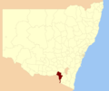
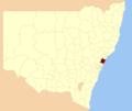
Tumut Shire (/ˈtjuːmət/) was a local government area in the South West Slopes region of New South Wales, Australia. Tumut Shire was established in 1928...
7 KB (355 words) - 07:07, 16 June 2024
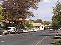
Ngunnawal Aboriginal peoples. Tumut is often referred to as the 'gateway to the snowy' Snowy Mountains Scheme. The former Tumut Shire was administered from offices...
21 KB (1,873 words) - 11:51, 1 September 2024
local government boundaries recommended that the Tumbarumba Shire merge with the Tumut Shire to form a new council. This recommendation was not supported...
8 KB (543 words) - 16:26, 29 April 2023
the Tumut River for the purpose of assisting the generation of hydroelectricity Tumut Shire, a former local government authority of the area Tumut and...
747 bytes (143 words) - 13:11, 17 May 2016
decades. She was a Councillor for Tumut Shire since 2000, and was then later elected to the position of Mayor. Tumut Shire Council later changed name to Snowy...
6 KB (523 words) - 16:14, 9 July 2024
Lockhart Shire. It also covers part of the Snowy Valleys Council, which was established following the merger of Tumut Shire and Tumbarumba Shire. Wagga...
8 KB (548 words) - 08:40, 10 June 2023

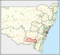
This area was formed on 12 May 2016 from the merger of the Tumut Shire and Tumbarumba Shire councils. The council area comprises 8,960 square kilometres...
7 KB (555 words) - 00:54, 21 August 2024
Yarrangobilly Shire. It was renamed as Gadara Shire on 12 February 1907. The shire offices were based in Tumut. Urban areas in the shire included Adelong...
3 KB (205 words) - 16:06, 29 April 2023
Yass Valley Council, Queanbeyan City Council, Tumut Shire and a small part going to the Cooma-Monaro Shire. It had a population of 9,654 and an area of...
1 KB (127 words) - 19:37, 23 May 2023

View map The Tumut (/ˈtjuːmət/) and Kunama railway lines are disused railway lines in the south of New South Wales, Australia. The Tumut line was a 104...
10 KB (1,008 words) - 18:54, 27 January 2024

"Gold Trails – explore Adelong – Tumut". Archived from the original on 23 April 2013. Retrieved 6 May 2013. "Tumut Shire Council – Adelong Falls Gold Mill...
27 KB (2,539 words) - 01:15, 2 June 2024

Shire Council Archived 23 June 2013 at the Wayback Machine Gold Trails – explore Adelong – Tumut Archived 23 April 2013 at the Wayback Machine Tumut Shire...
177 KB (20,136 words) - 11:36, 22 June 2024
Tumut mountain ranges, Gundagai is 390 kilometres (240 mi) south-west of Sydney. Until 2016, Gundagai was the administrative centre of Gundagai Shire...
82 KB (9,039 words) - 12:27, 1 September 2024
"John Rayner leads new Georges River Council". St George & Sutherland Shire Leader. Retrieved 15 May 2016. "PROCLAMATION". New South Wales Government...
152 KB (6,257 words) - 00:52, 2 July 2024

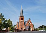
Tumut Post Office is a heritage-listed post office at 82–84 Wynyard Street, Tumut, New South Wales, Australia. It was added to the Australian Commonwealth...
20 KB (2,793 words) - 12:18, 14 April 2023

Adelong Falls Reserve. Tumut Shire Council (2010). Adelong Falls Reserve Plan of Management. "Crushing blow for Falls plan". Tumut & Adelong Times. 18 November...
13 KB (1,609 words) - 21:42, 24 May 2024
existing municipalities. The commission also provided the name for each Shire, avoiding where possible the use of the names of existing municipalities...
63 KB (3,808 words) - 12:21, 26 February 2024

Warringah Council (redirect from Warringah Shire Council)
Warringah Shire Council, and became "Warringah Council" in 1993. In 1992, Pittwater Council was formed when the former A Riding of Warringah Shire voted to...
41 KB (4,173 words) - 05:14, 26 June 2024
through secondary school sports associations and to the community of the Tumut Shire. Dorothy Lorraine Hays For services to the community of the Coffs Harbour...
118 KB (92 words) - 01:00, 31 January 2024

Wyong Shire was a local government area located in the Central Coast region of New South Wales, Australia. The incorporation of the Wyong area dates back...
80 KB (6,387 words) - 14:25, 3 August 2024
Opportunity Shop. Vincent "Vince" Bulger For service to the community of the Tumut Shire through activities promoting Indigenous culture, tradition and reconciliation...
137 KB (674 words) - 23:06, 24 August 2024
Citation Notes June Patricia Adams For service to the community of the Tumut Shire Sister Josephine Mary Agnew For service to nursing, particularly through...
58 KB (124 words) - 01:00, 27 April 2024

residence for workers in the nearby Tumut 1 and Tumut 2 power stations and electrical switching yards, and Tumut Pondage dam. Only persons directly employed...
13 KB (960 words) - 11:31, 26 August 2024

Jerilderie Shire was a local government area in the Murray region of southern New South Wales, Australia. The Shire was located adjacent to the Newell...
6 KB (457 words) - 11:08, 28 March 2024

Back' A.C. Butcher, Gundagai, pp 212-213 "The Pioneers' Memorial". The Tumut and Adelong Times. Vol. 78, no. 34. New South Wales, Australia. 20 September...
11 KB (1,267 words) - 12:47, 3 September 2024
formed on 12 May 2016 following the merger of the City of Gosford and Wyong Shire Councils. The council comprises an area of 1,681 square kilometres (649 sq mi)...
84 KB (7,265 words) - 22:52, 4 September 2024

City of Gosford (redirect from Gosford Shire)
creating Gosford Shire and Wyong Shire, and the final boundaries of Gosford City Council date from this period. From 1 January 1980, Gosford Shire was granted...
94 KB (7,417 words) - 14:25, 3 August 2024

Murray Shire was a local government area in the Murray region of south western New South Wales, Australia. It included the towns of Moama and Mathoura...
7 KB (450 words) - 21:14, 6 May 2024

most recently in July 1966. In August 2019 there was snow on the ground in Tumut at 280 metres (920 ft), with reports of flakes as far north-west as Junee...
37 KB (3,663 words) - 08:42, 5 September 2024
or Ngarigo language. Tumbarumba and surrounds now lie within the Brungle/Tumut Aboriginal Land Council Area. The settler community was established in the...
22 KB (1,690 words) - 00:17, 31 August 2024