Humåtak, Guam (redirect from Umatac)
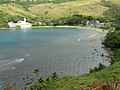
Humåtak (formerly Umatac) is a village on the southwestern coast of the United States territory of Guam. The month of March in the Chamorro language is...
8 KB (753 words) - 07:52, 17 August 2024
The Umatac River is a river in the United States territory of Guam. List of rivers of Guam U.S. Geological Survey Geographic Names Information System:...
804 bytes (31 words) - 18:24, 5 April 2021

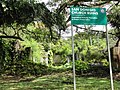
The Umatac Outdoor Library, located on Guam Highway 4 in Umatac, Guam, was built in 1933 by Francisco Quinata Sanchez and Umatac villagers. It was listed...
2 KB (84 words) - 18:55, 19 February 2024

The Umatac Outdoor Library, built in 1933, was the first library in southern Guam....
107 KB (9,960 words) - 21:06, 30 August 2024

Community College, There is also the Guam Public Library System and the Umatac Outdoor Library. Weriyeng is one of the last two schools of traditional...
69 KB (7,470 words) - 11:58, 29 July 2024

of the Alutom formation caldera.: 7 The last volcanic layer, called the Umatac formation, was formed by the third and final eruption, which surrounded...
26 KB (2,638 words) - 02:54, 21 August 2024

the command of Ferdinand Magellan. Historically, the southern village of Umatac, Guam has been credited as the site of the Spanish landing. As confirmation...
38 KB (4,134 words) - 03:30, 29 August 2024
Polysius (redirect from UMATAC Industrial Processes)
Thyssenkrupp Polysius GmbH (thyssenkrupp Polysius GmbH) is a global industrial company specializing in the manufacture and sale of plants and machinery...
10 KB (1,039 words) - 11:53, 12 June 2024
to: Bolanos River, island of Guam Mount Bolanos (368 m or 1,207 ft), near Umatac, island of Guam Or to: Bolaños River, in Mexico Bolaños Municipality, a...
307 bytes (66 words) - 17:48, 6 July 2015
Atlantic and Pacific Oceans, from Spain. History credits the village of Umatac as his landing place, but drawings from the navigator's diary suggest that...
53 KB (6,105 words) - 08:42, 30 August 2024

March 1521 and anchored the three ships that were left of his fleet in Umatac Bay, before proceeding to the Philippines, where he met his death during...
46 KB (4,216 words) - 09:36, 31 August 2024

others believe it is the phallic-shaped Laso de Fua located in Fouha Bay in Umatac. Ancient Chamorros engaged in ancestor veneration, but did not practice...
40 KB (4,396 words) - 04:24, 27 July 2024
the United States territory of Guam. Llicho's closest populated area is Umatac. It is 246.9 meters (810 ft) above sea level. "Mount Llicho". Geographic...
1 KB (62 words) - 19:03, 19 July 2024
of GH-2 at the Magellan Monument in Umatac (the road officially changes designations at the crossing of the Umatac River). The road then begins its counterclockwise...
3 KB (215 words) - 09:07, 26 August 2024
north direction, from the Magellan Monument in the southern community of Umatac in a general northward direction to the community of Santa Rita, where it...
2 KB (112 words) - 09:07, 26 August 2024
Fouha Bay Site is a prehistoric archaeological site near the village of Umatac on the southwestern coast of Guam. First identified in 1977 during a systematic...
2 KB (227 words) - 18:02, 30 January 2022

surrounded on all sides by major lava flows in the early Miocene that formed the Umatac Formation. The formation was first dated using foraminifera fossils in a...
8 KB (1,145 words) - 08:47, 14 July 2024

Fort Nuestra Señora de la Soledad (category Umatac, Guam)
(Spanish: Fuerte de Nuestra Señora de la Soledad) is a fortification near Umatac, Guam. Built by the Spanish probably between 1802 and 1819, it was the fourth...
2 KB (151 words) - 21:48, 18 August 2024
Location State First built Use Notes Fort Nuestra Señora de la Soledad Umatac GU 1802–1819 Military Built by the Spanish Empire, and was used to protect...
136 KB (2,400 words) - 21:53, 19 August 2024

List of craters on Mars: O–Z (redirect from Umatac (crater))
(Ulya) 8.6 1991 Russia place name WGPSN Umatac 42°48′N 222°48′W / 42.8°N 222.8°W / 42.8; -222.8 (Umatac) 17.5 1979 Guam place name WGPSN Urk 23°24′N...
63 KB (334 words) - 17:51, 3 December 2023
The San Dionisio Church Ruins are a historic ruins on Route 2 in Umatac, Guam. They are the remains of a church that was built in 1862 and destroyed by...
2 KB (203 words) - 21:05, 11 September 2022
School is a historic school building on the north side of Guam Highway 2 in Umatac, Guam. It is a single-story International style structure, with two classroom...
2 KB (170 words) - 23:18, 6 April 2024

Partition issued by Pope Alexander VI. Other churches were built at Funa near Umatac, at Tepungan by Asan, at Ritidian, at Tarrague, at Dededo and at Orote....
5 KB (520 words) - 09:00, 15 August 2024
technology started in 1970. In 1975, its inventor, William Taciuk, formed the UMATAC Industrial Processes (now part of Polysius) to further its development....
13 KB (1,242 words) - 23:09, 6 July 2024
Yigo 73X: Mangilao, Barrigada 789: Yona, Talofofo 828: Merizo, Inarajan, Umatac 969: DoCoMo Pacific subscribers List of NANP area codes Communications in...
5 KB (596 words) - 11:41, 12 January 2023
1975 133 Umatac Ridge Umatac June 5, 1975 1187 Umatac Pillbox Umatac June 16, 1988 March 4, 1991 1662 Umatac Outdoor Library Umatac September 14, 1999 November...
17 KB (299 words) - 03:49, 1 August 2024

Guåhan (Chamorro) Category County equivalent Location Guam Number 19 Populations 647 (Umatac) – 44,908 (Dededo) Areas 0.89 sq mi (2.3 km2) (Sinajana) – 35.61 sq mi (92...
8 KB (440 words) - 17:42, 19 February 2024
most of the village's population lives near sea level. The village of Umatac is also at a high elevation. 3750 feet (1143 m) Volcano Hawaii 6290 feet...
24 KB (895 words) - 01:51, 3 April 2024
Tinechong River Togcha River Toguan River Tolaeyuus River Topony River Ugum River Umatac River Yledigao River Ylig River List of rivers in U.S. insular areas...
2 KB (213 words) - 12:20, 30 December 2022

Toto 2,235 Mongmong-Toto-Maite Tumon 2,230 Tamuning Ukudu 806 Dededo Umatac 548 Umatac University of Guam 3,496 Mangilao Upper Tumon 3,566 Tamuning Windward...
5 KB (47 words) - 02:20, 1 January 2023