
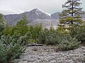
The Upper Kolyma Highlands (Russian: Верхнеколымское нагорье, romanized: Verkhnekolymskoye Nagorye) is a highland area in Magadan Oblast, Far Eastern Federal...
5 KB (455 words) - 13:52, 12 May 2023

Kolyma (Колыма́, IPA: [kəɫɨˈma]) or Kolyma Krai (Колымский край) is a historical region in the Russian Far East that includes the basin of Kolyma River...
36 KB (4,508 words) - 03:35, 12 August 2024
1,800 meters (4,900 to 5,900 ft). To the west and southwest the Upper Kolyma Highlands are bound by the Seymchan-Buyunda Depression to the north and the...
5 KB (446 words) - 05:01, 31 March 2024

Kolyma basin and the basins of rivers flowing into the Sea of Okhotsk. Kolyma flows across the Upper Kolyma Highlands roughly southwards in its upper...
15 KB (1,598 words) - 03:32, 12 August 2024

the Kolyma. It was designed by Lenhydroproject. Filling began in 1980 and it was commissioned in 1995. The Kolyma Reservoir is in the Upper Kolyma Highlands...
5 KB (301 words) - 19:39, 23 September 2023

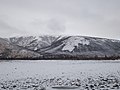
Susumansky District of Magadan Oblast, Russia. It is located in the Upper Kolyma Highlands, in the basin of the Ayan-Yuryakh River, 65 kilometers (40 mi) northwest...
4 KB (577 words) - 19:09, 20 August 2024
Kolyma River Kolyma Reservoir, an artificial lake in Magadan Oblast Upper Kolyma District (Verkhnekolymsky Ulus) Upper Kolyma Highlands Middle Kolyma...
1 KB (170 words) - 09:35, 4 August 2023

the other side of the Kolyma basin, the Seymchan forms the Seymchan-Buyunda Depression, which limits the Upper Kolyma Highlands from the east. Its main...
4 KB (250 words) - 09:16, 9 January 2022

Buyunda (category Tributaries of the Kolyma)
the facing bank of the Kolyma basin, the Buyunda forms the Seymchan-Buyunda Depression, which limits the Upper Kolyma Highlands from the east. The name...
5 KB (342 words) - 21:41, 2 November 2023
East Siberian Mountains (redirect from East Siberian Highlands)
Tas-Kystabyt Upper Kolyma Highlands Angachak Range Kyun-Tas Polousny Range Kondakov Plateau Suor Uyata Ulakhan-Sis Range Alazeya Plateau Yukaghir Highlands Nera...
7 KB (595 words) - 00:14, 23 January 2024
originated in the Even language. The source of the Chyolomdzha is in the Upper Kolyma Highlands. The river heads in a roughly southern direction, flowing fast across...
4 KB (314 words) - 07:17, 9 December 2023

boundaries of the mountain system are the Yana–Oymyakon Highlands in the southwest, the Upper Kolyma Highlands in the southeast, and the Momo-Selennyakh Depression...
11 KB (1,151 words) - 09:14, 4 June 2024
Tenka (river) (category Tributaries of the Kolyma)
District, which is named after it. The Tenka flows through the Upper Kolyma Highlands. It heads first roughly northwards, then when it is joined by the...
3 KB (223 words) - 11:03, 3 February 2022
of rivers Rasava and Lozovaya flowing from the Kheidzhan Range, Upper Kolyma Highlands. The Taui flows first southeastwards and then roughly eastwards...
4 KB (274 words) - 20:58, 14 June 2022
settlement is located in the Upper Kolyma Highlands by the confluence of the Mylga and the Taskan, a left tributary of the Kolyma that flows from the Chersky...
5 KB (226 words) - 14:57, 10 September 2022

East Siberian Lowland (redirect from Yana-Kolyma Lowland)
низменность, romanized: Vostochno-Sibirskaya nizmennost), also known as Yana-Kolyma Lowland (Russian: Яно-Колымская низменность, romanized: Yano-Kolymskaya...
8 KB (859 words) - 13:12, 21 February 2024

and Akhchan. The river has its source in the Olsky Plateau of the Upper Kolyma Highlands, 35 km (22 mi) to the west of Atka at an elevation of about 700...
4 KB (323 words) - 07:46, 25 June 2024

Maymandzhin Range (category Kolyma Mountains)
beyond the northern end of the range, and to the west lie the Upper Kolyma Highlands. The Yama has its sources in the southwestern slopes of the Maymandzhin...
5 KB (309 words) - 13:39, 11 October 2023

Kulu (river) (category Tributaries of the Kolyma)
through the Upper Kolyma Highlands. It divides into branches across a floodplain and finally it meets the Ayan-Yuryakh forming the Kolyma. The Kulu is...
4 KB (349 words) - 17:14, 10 April 2024
Ayan-Yuryakh (category Tributaries of the Kolyma)
of the river is in the Khalkan Range. The river flows across the Upper Kolyma Highlands and is fed primarily by rain and snow. Its main tributary is the...
3 KB (127 words) - 17:34, 25 July 2023
has its source in the Olsky Plateau, at the eastern end of the Upper Kolyma Highlands, 30 km (19 mi) southwest of Atka at an elevation of 1,160 metres (3...
3 KB (209 words) - 16:21, 24 March 2022
the Nera Plateau to the northeast. To the east it is bound by the Upper Kolyma Highlands and to the south it overlaps with the Suntar Khayata Range. The...
3 KB (232 words) - 13:41, 22 July 2024

Byoryolyokh (Ayan-Yuryakh) (redirect from Byoryolyokh (Kolyma Basin))
upstream from its confluence with the Kulu. The river flows across the Upper Kolyma Highlands and is fed primarily by rain and snow. Many stretches freeze to...
5 KB (411 words) - 18:58, 14 June 2022
Debin (river) (category Tributaries of the Kolyma)
the eastern end of the Chersky Range, where it overlaps with the Upper Kolyma Highlands. There is continuous permafrost in the area. The river heads first...
5 KB (445 words) - 12:59, 13 January 2022
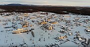
Census); 1,946 (1989 Soviet census). Shiroky is located in the Upper Kolyma Highlands by the Byoryolyokh river. Russian Federal State Statistics Service...
2 KB (251 words) - 09:07, 3 January 2022

northern end of the Upper Kolyma Highlands, in the southernmost sector of the Chersky Range System. The range is bound by the Kolyma River valley from the...
4 KB (356 words) - 13:39, 22 July 2024

to the southwest. The Yudoma-Maya Highlands are located to the south of the range and the Upper Kolyma Highlands to the northeast. The Suntar-Khayata...
7 KB (623 words) - 16:51, 26 July 2024
Sugoy (category Tributaries of the Kolyma)
of two small rivers of the Kolyma Highlands at an elevation of 515 metres (1,690 ft) and flows roughly westwards in its upper course. After a sharp bend...
3 KB (221 words) - 12:32, 12 June 2020

Seymchan (urban-type settlement) (category Kolyma basin)
limits the Upper Kolyma Highlands from the east. The town lies on the right bank of the Seymchan River, near its confluence with the Kolyma, about 350...
9 KB (863 words) - 23:10, 27 August 2024
ranges of the Chersky mountain system to the northeast, the Upper Kolyma Highlands to the southeast and the Tas-Kystabyt (Sarychev Range) to the southwest...
3 KB (241 words) - 08:36, 3 January 2022