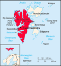
Van Mijenfjorden is the third-longest fjord in Norway's Svalbard archipelago. It lies in the southern portion of Spitsbergen island, south of Nordenskiöld...
2 KB (208 words) - 19:09, 20 February 2020
Nordenskiöld Land National Park (redirect from Van Mijenfjorden National Park)
covers the southern part of Nordenskiöld Land, on the north shore of Van Mijenfjorden. The park includes Reindalen, which is Svalbard's largest ice-free...
2 KB (117 words) - 03:51, 29 October 2024
Birkelandodden is the northern point of the island Akseløya between Van Mijenfjorden and Bellsund at Spitsbergen, Svalbard. The point is named after Kristian...
1 KB (108 words) - 16:47, 1 November 2023
sailed from Scapa Flow on 3 September and anchored in Lowe Sound (Van Mijenfjorden) several days later. From 9 to 13 September, relays of destroyers were...
41 KB (5,625 words) - 11:30, 15 February 2024
Isfjorden, in Kings Bay (Quade Hock) further north along the coast and in Van Mijenfjorden to the south. The settlements attracted colonists from many places;...
22 KB (2,620 words) - 15:15, 31 October 2024
Liljevalchfjellet, ending at Slettvika and Liljevalchneset at the northern side of Van Mijenfjorden. The valley is named after mineralogist Gustaf Nordenskiöld. "Gustavdalen...
808 bytes (78 words) - 19:17, 12 November 2023
island (about 8.5 km long and 1 km wide) at the mouth of Van Mijenfjorden, separating Van Mijenfjorden from Bellsund. It is separated from the mainland by...
2 KB (175 words) - 20:19, 12 January 2023
Van Muydenbukta and Van Mijenfjorden on the west coast of Spitsbergen and Kapp Muyen on the west coast of Jan Mayen are named after him. Willem van Muy(d)en...
6 KB (846 words) - 14:54, 31 October 2024
and Langlifjellet, and north of Løyndbreen, at the southern side of Van Mijenfjorden. East of the mountain is the valley of Bromelldalen. "Sven Nilssonfjellet...
1 KB (117 words) - 08:19, 19 September 2024
from the mountain pass Skardalspasset down to the northern side of Van Mijenfjorden. The valley is named after Swedish chemist Jöns Jacob Berzelius. The...
1 KB (89 words) - 19:04, 12 November 2023
migratory seabirds. Stabbursdalen Finnmark 1970 747 km2 (288 sq mi) Van Mijenfjorden Svalbard 2021 4,251 km2 (1,641 sq mi) Varangerhalvøya Finnmark 2006...
27 KB (1,139 words) - 12:04, 5 January 2024
Semmeldalselva debouches into the bay of Kaldbukta, at the northern side of Van Mijenfjorden. "Semmeldalselva (Svalbard)". Norwegian Polar Institute. Retrieved...
880 bytes (89 words) - 08:04, 11 September 2023
cannonball concretions. Cannonball concretions have also been reported from Van Mijenfjorden, Spitsbergen; near Haines Junction, Yukon Territory, Canada; Jameson...
56 KB (6,225 words) - 03:40, 24 October 2024
Governor of Svalbard, Johannes Gerckens Bassøe. It is located between Van Mijenfjorden and Van Keulenfjorden, west of Langlifjellet and south of Løyndbreen, with...
1 KB (131 words) - 13:05, 17 November 2023
Alexandtrovitch Rusanov in 1912. It explored the areas around Bellsund and van Mijenfjorden. It later went northwards to Isfjorden and visited Grønfjorden and...
25 KB (3,255 words) - 18:18, 24 October 2024
instead. Most of Store Norske's production was done at Sveagruva, on Van Mijenfjorden, 60 kilometers (37 mi) south of Longyearbyen. No roads connect the...
81 KB (7,386 words) - 13:25, 5 November 2024
geologist Sven Anders Bernhard Lundgren. The mountain is located south of Van Mijenfjorden, north of the glaciers of Vengebreen and Rånebreen, west of the valley...
1,014 bytes (100 words) - 18:38, 20 February 2020
The valley debouches into Braganzavågen, a bay in the inner part of Van Mijenfjorden. "Kjellströmdalen (Svalbard)". Norwegian Polar Institute. Retrieved...
2 KB (71 words) - 09:22, 13 November 2023
Isfjorden, in Kings Bay (Quade Hock) further north along the coast and in Van Mijenfjorden (Lowe Sound) to the south. The settlements attracted colonists of different...
45 KB (6,232 words) - 15:15, 25 June 2024
Wijdefjorden (108 km or 67 mi), followed by Isfjorden (107 km or 66 mi), Van Mijenfjorden (83 km or 52 mi), Woodfjorden (64 km or 40 mi), and Wahlenbergfjorden...
110 KB (10,336 words) - 13:37, 18 November 2024
mouth of Van Mijenfjorden at Spitsbergen, Svalbard; between Mariaholmen and Måseneset. While Akselsundet is regarded as the main entrance into Van Mijenfjorden...
1 KB (102 words) - 09:56, 10 August 2022
"Medium-scale experiment in consolidation of an artificial sea ice ridge in Van Mijenfjorden, Svalbard", Cold Regions Science and Technology, 181, Bibcode:2021CRST...
21 KB (2,423 words) - 03:06, 11 November 2024
Mariaholmen is an islet in Nathorst Land at the mouth of Van Mijenfjorden at Spitsbergen, Svalbard. It is located south of Akseløya, between Akseløya and...
2 KB (133 words) - 09:46, 15 September 2024
listed here: Wijdefjorden, 108 km (67 mi) Isfjorden, 107 km (66 mi) Van Mijenfjorden, 83 km (52 mi) Woodfjorden, 64 km (40 mi) Wahlenbergfjord, 46 km (29 mi)...
13 KB (1,180 words) - 02:27, 16 June 2024
Kaldbukta is a bay in Van Mijenfjorden in Nordenskiöld Land at Spitsbergen, Svalbard. The bay has a width of about 11.5 kilometers. The large valley Reindalen...
661 bytes (77 words) - 13:47, 8 November 2021
mountain pass Reindalspasset, and ending into the bay Kaldbukta in Van Mijenfjorden. It has created one of Svalbard's largest river deltas. Among its tributary...
1 KB (120 words) - 13:08, 9 November 2023
Nathorst Land at Spitsbergen, Svalbard. The group is located south of Van Mijenfjorden, between Scheelebreen and Danzigdalen. The highest mountain in the...
1 KB (107 words) - 12:45, 17 November 2023
Heer Land at Spitsbergen, Svalbard. It forms the southern branch of Van Mijenfjorden. The glaciers of Scheelebreen and Paulabreen debouche into the bay...
885 bytes (79 words) - 16:47, 20 September 2024
in Kongsfjorden (Kings Bay), north of Isfjorden up the coast and in Van Mijenfjorden to the south. The settlements had attracted colonists from several...
23 KB (2,658 words) - 22:24, 10 August 2024
between Krylbreen, Krylen and Frysjadalen, at the southern side of Van Mijenfjorden. It is named after Swedish geographer and geologist Göran Wahlenberg...
2 KB (83 words) - 04:46, 21 February 2022


