
Vermont Route 125 (VT 125) is a 35.901-mile-long (57.777 km) east–west state highway in Addison County, Vermont, United States. The route begins at an...
14 KB (1,360 words) - 02:29, 19 March 2023

Middlebury is crossed by U.S. Route 7, Vermont Route 23, Vermont Route 30, Vermont Route 116, and Vermont Route 125. It is bordered by the towns of...
26 KB (2,439 words) - 19:51, 22 September 2024

which is 1281 ft above Lake Champlain. Vermont Route 17 Vermont Route 22A Vermont Route 23 Vermont Route 125 As of the census of 2000, there were 1,393...
12 KB (839 words) - 03:58, 11 May 2024

Granville and Warren, and south into Rochester and Stockbridge. Vermont Route 125 leaves Route 100 in Hancock village and leads west, across Middlebury Gap...
10 KB (846 words) - 04:09, 11 May 2024

Vermont Route 30 (VT 30) is a 111.870-mile-long (180.037 km) north–south state highway in the U.S. state of Vermont. VT 30 runs from U.S. Route 5 (US...
11 KB (546 words) - 02:03, 26 July 2024
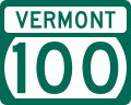
Vermont Route 100 (VT 100) is a north–south state highway in Vermont in the United States. Running through the center of the state, it travels nearly the...
14 KB (497 words) - 10:26, 5 October 2024

north–south through Cornwall, while Vermont Route 125 passes east–west through the northern part of the town. Vermont Route 74 leads southwest from the center...
15 KB (844 words) - 04:00, 11 May 2024

S. Route 7 Vermont Route 12A Vermont Route 17 Vermont Route 22A Vermont Route 23 Vermont Route 30 Vermont Route 53 Vermont Route 73 Vermont Route 74 Vermont...
24 KB (2,069 words) - 19:53, 22 September 2024
Route 125 or Highway 125 can refer to multiple roads: Winnipeg Route 125 Nova Scotia Highway 125 Ontario Highway 125 Prince Edward Island Route 125 Quebec...
5 KB (335 words) - 10:48, 29 August 2024

U.S. Route 7 (US 7) is a north–south highway extending from southern Connecticut to the northernmost part of Vermont. In Vermont, the route extends for...
20 KB (959 words) - 22:05, 8 October 2024
village of Highgate Springs, Vermont, immediately south of the Canada–United States border. US 7 in Connecticut (also known as Route 7, Ethan Allen Highway...
17 KB (1,672 words) - 22:55, 10 October 2024

Vermont Route 22A (VT 22A) is a 44.738-mile-long (71.999 km) state highway in western Vermont, United States. It is the northward continuation of New...
14 KB (1,240 words) - 20:42, 18 October 2022

Vermont Route 127 (VT 127) is a state highway in Chittenden County, Vermont, United States. It currently exists in two segments: a signed, locally maintained...
13 KB (1,184 words) - 01:14, 11 June 2024

Highways, and Vermont routes. Routes in Vermont are abbreviated as "VT #" by VTrans and also abbreviated as "VT Route #" and "Route #" in common usage...
62 KB (1,082 words) - 17:43, 14 August 2024

Vermont (/vərˈmɒnt/ vər-MONT) is a state in the New England region of the Northeastern United States. It borders Massachusetts to the south, New Hampshire...
217 KB (21,658 words) - 03:58, 8 October 2024

Vermont Route 23 (VT 23) is a 7.370-mile-long (11.861 km) north–south state highway in Addison County, Vermont, United States. It is maintained by the...
6 KB (484 words) - 03:08, 19 March 2023
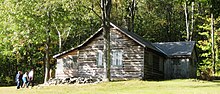
a National Historic Landmark in Ripton, Vermont. It is a 150-acre (61 ha) farm property off Vermont Route 125 in the Green Mountains where American poet...
5 KB (571 words) - 04:40, 9 August 2023

Vermont Route 17 (VT 17) is a 40.409-mile-long (65.032 km) state highway in western Vermont in the United States. The western terminus of the route is...
14 KB (1,226 words) - 15:37, 4 January 2024

mont-PEEL-yər) is the capital of the U.S. state of Vermont and the county seat of Washington County. The site of Vermont's state government, it is the least populous...
43 KB (4,400 words) - 12:36, 5 October 2024

New England road marking system (redirect from New England Interstate Route 17)
then U.S. Route 4, Vermont Route 30, U.S. Route 7, U.S. Route 2, and Vermont Route 225. Route 30A was superseded by Vermont Route 22A, and Route 30B was...
158 KB (6,445 words) - 17:10, 1 February 2024
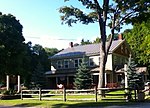
Waybury Inn (category Hotels in Vermont)
Main Street (Vermont Route 125), near the eastern end of East Middlebury village. It is set near the westernmost end of one of the major routes across the...
4 KB (494 words) - 15:22, 24 June 2024

Interstate 93 (redirect from Interstate 93 (Vermont))
Highway in the New England states of Massachusetts, New Hampshire, and Vermont in the United States. Spanning approximately 190 miles (310 km) along a...
77 KB (5,918 words) - 21:17, 28 July 2024

Vermont Route 116 (VT 116) is a 40.759-mile-long (65.595 km) state highway in Vermont. It travels north from U.S. Route 7 (US 7) in Middlebury, where...
8 KB (830 words) - 03:22, 19 March 2023

Milton is a town in Chittenden County, Vermont, United States. As of the 2020 census, the population was 10,723. According to local legend, the town was...
25 KB (2,459 words) - 20:01, 31 August 2024
Presidential Range (Green Mountains) (category Mountain ranges of Vermont)
Gap on Vermont Route 125 and winds northward 28.9 miles (46.5 km) along the ridge of the Green Mountains to Appalachian Gap on Vermont Route 17: Map...
13 KB (1,165 words) - 18:00, 19 December 2020

Batten Kill in the Valley of Vermont, with the Taconic Mountains to the west and the Green Mountains to the east. Vermont Route 7A is the main road through...
9 KB (727 words) - 03:32, 11 July 2024

Ferrisburgh is a town in Addison County, Vermont, United States. It was founded June 24, 1762. The population was 2,646 at the 2020 census. The town is...
17 KB (1,534 words) - 02:35, 26 August 2024

multi-state route with Vermont and Maine, part of 1920s-era New England Interstate Route 9. The western terminus of NH 9 is at the Vermont state line in...
24 KB (1,535 words) - 00:04, 12 May 2024

western terminus of the route is at an intersection with NY 5 in the town of St. Johnsville. Its eastern terminus is at the Vermont state line in Hoosick...
23 KB (1,942 words) - 02:04, 17 April 2024

Middlebury Gorge Concrete Arch Bridge (category Road bridges on the National Register of Historic Places in Vermont)
historic concrete arch bridge, carrying Vermont Route 125 over the Middlebury River in eastern Middlebury, Vermont. The bridge was built in 1924, and is...
3 KB (304 words) - 23:05, 24 January 2022