
currently aligns with the council's Waitākere Ward. The Waitākere Ranges local board area includes the Waitākere Ranges and surrounds. Laingholm, Waima,...
3 KB (168 words) - 22:14, 9 August 2024

Waitākere Ranges Local Board is one of the 21 local boards of the Auckland Council, and is one of the two boards overseen by the council's Waitākere Ward...
13 KB (853 words) - 07:42, 4 June 2024
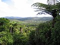
central Auckland. The ranges are part of the Waitākere Ranges Regional Park. From 1 May 2018 the forested areas of the Waitākere Ranges Regional Park were...
43 KB (4,116 words) - 12:57, 2 June 2024

Titirangi (category Waitākere Ranges Local Board Area)
Titirangi is a suburb of West Auckland in the Waitākere Ranges local board area of the city of Auckland in northern New Zealand. It is an affluent, residential...
21 KB (2,060 words) - 23:49, 22 July 2024

Glen Eden, New Zealand (redirect from Waitakere Seventh-day Adventist School)
foothills of Waitākere Ranges. Originally known as Waikumete, the suburb gained the name Glen Eden in 1921. The suburb is in the Waitākere Ward, one of...
32 KB (3,214 words) - 15:33, 6 June 2024

Karekare, New Zealand (category Waitākere Ranges Local Board Area)
pp. 21. Waitākere Ranges Local Board (October 2015). Local Area Plan: Te Henga (Bethells Beach) and the Waitākere River Valley. Waitākere Ranges Heritage...
17 KB (1,941 words) - 10:43, 21 August 2024

ISBN 0-476-00544-2. Waitākere Ranges Local Board (October 2015). Local Area Plan: Te Henga (Bethells Beach) and the Waitākere River Valley. Waitākere Ranges Heritage...
6 KB (559 words) - 07:11, 12 April 2024

Swanson, New Zealand (category Waitākere Ranges Local Board Area)
Each area elects a local board, and the residents of the Waitākere Ranges and Henderson-Massey elect two councillors from the Waitākere ward to sit on the...
22 KB (2,514 words) - 03:32, 15 April 2024

ISBN 0-473-00983-8. Waitākere Ranges Local Board (October 2015). "Local Area Plan: Te Henga (Bethells Beach) and the Waitākere River Valley. Waitākere Ranges Heritage...
9 KB (826 words) - 03:44, 16 June 2024

Henderson-Massey Local Board is one of the 21 local boards of the Auckland Council, and is overseen by the council's Waitākere Ward councillors. The board's administrative...
10 KB (676 words) - 22:52, 19 July 2024

Huia, New Zealand (category Waitākere Ranges Local Board Area)
coastal settlement in West Auckland, New Zealand and forms part of the Waitākere Ranges Regional Park. The majority of houses in Huia are located along Huia...
17 KB (1,554 words) - 15:07, 24 August 2024

Piha (category Waitākere Ranges Local Board Area)
and several streams in the area. The coastline and forested Waitākere Ranges offer a number of walks, or tramps, ranging from easy to very difficult...
16 KB (1,778 words) - 07:39, 16 July 2024

Oratia (category Waitākere Ranges Local Board Area)
a part of the Waitematā-Waitākere foothills ecological zone. Sheltered from the Tasman Sea by the Waitākere Ranges, the area was traditionally dominated...
20 KB (1,876 words) - 03:19, 27 August 2024

current Auckland Council. The name "Waitakere" comes from the Waitākere River in the Waitākere Ranges. Waitakere City was formed by the amalgamation of...
7 KB (713 words) - 03:35, 9 August 2024
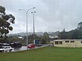
Waitākere, often called Waitākere Township, is a small, mostly rural settlement to the northwest of Auckland, New Zealand. The settlement is in the traditional...
9 KB (810 words) - 03:51, 17 June 2024

Scenic Drive, Auckland (category Waitākere Ranges Local Board Area)
Scenic Drive is a road that runs through the bush-clad Waitākere Ranges from Titirangi to Swanson on the western outskirts of Auckland, New Zealand. It...
6 KB (712 words) - 23:36, 28 July 2024

Te Toiokawharu (category Waitākere Ranges Local Board Area)
hill in the Waitākere Ranges of the Auckland Region of New Zealand's North Island. At 474-metres, it is the tallest peak of the Waitākere Ranges. The peak...
7 KB (709 words) - 22:29, 22 March 2024

Arataki Visitor Centre (category Waitākere Ranges Local Board Area)
often described as the gateway to the Waitākere Ranges. The centre provides information about the Waitākere Ranges, and organises educational events. The...
8 KB (722 words) - 20:50, 28 July 2024

Te Henga / Bethells Beach (category Waitākere Ranges Local Board Area)
began forming in the mid-1920s. The Waitākere River catchment consists of roughly 70 km2 of the bush-clad Waitākere Ranges. Located on the west coast of the...
20 KB (2,398 words) - 23:58, 26 August 2024

Whatipu (category Waitākere Ranges Local Board Area)
the north is Karekare. Whatipu is located at the southern end of the Waitākere Ranges. Shifting sands have substantially changed the beach since the 1940s...
12 KB (1,319 words) - 22:08, 11 August 2024

Hoani Waititi Marae (category Waitākere Ranges Local Board Area)
Reserve Management Plan" (Prepared by Waitakere City Council: Parks Planning Unit). Waitakere Community Board. 31 August 2010. Archived (PDF) from the...
8 KB (836 words) - 08:42, 23 October 2023

Te Rau-o-te-Huia / Mount Donald McLean (category Waitākere Ranges Local Board Area)
highest peak of the Waitākere Ranges that borders the Manukau Harbour. The hill is a 389 m (1,276 ft) peak in the Waitākere Ranges, approximately 2 km...
9 KB (882 words) - 17:18, 26 August 2024
Waitākere railway station is a disused station on the North Auckland Line located in the village of Waitākere, to the north-west of Auckland, New Zealand...
7 KB (788 words) - 08:35, 30 July 2024

Whatipu Lodge (category Waitākere Ranges Local Board Area)
and wiring himself with funding provided by the local government. In 1971 the Auckland Harbour Board leased 1,100 acres of land at Whatipu to the Auckland...
17 KB (1,846 words) - 13:40, 15 August 2024

Anawhata (category Waitākere Ranges Local Board Area)
along the West Coast of West Auckland, between the Tasman Sea and the Waitākere Ranges. It is located south of Te Henga / Bethells Beach, and north of Piha...
5 KB (419 words) - 05:53, 12 April 2024

Kakamatua Inlet (category Waitākere Ranges Local Board Area)
2022. Waitākere Ranges Local Board (October 2015). "Local Area Plan: Te Henga (Bethells Beach) and the Waitākere River Valley. Waitākere Ranges Heritage...
8 KB (581 words) - 09:01, 19 December 2023

Maungakiekie-Tāmaki, Ōrākei, Ōtara-Papatoetoe, Puketāpapa, Upper Harbour, Waitākere Ranges, Waitematā and Whau. Rural townships and localities outside of the...
36 KB (445 words) - 19:46, 1 June 2024

Studio West (film studio) (category Waitākere Ranges Local Board Area)
2006 Wendy Wu: Homecoming Warrior 2006 Ozzie 2007 Johnny Kapahala: Back on Board 2007 The Tattooist 2009 The Strength of Water 2009 The Vintner's Luck 2009...
7 KB (482 words) - 01:39, 17 January 2024
Lake Wainamu (category Waitākere Ranges Local Board Area)
ISBN 0-473-00983-8. Waitākere Ranges Local Board (October 2015). "Local Area Plan: Te Henga (Bethells Beach) and the Waitākere River Valley. Waitākere Ranges Heritage...
8 KB (787 words) - 04:41, 22 December 2023
2023 New Zealand census (section Population counts by territorial authority and Auckland local board areas)
week extension of the census for the worst affected areas. People living in cyclone-affected areas including the Far North District, Gisborne District...
35 KB (2,028 words) - 00:18, 19 June 2024