
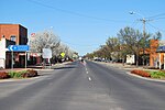
Yass (/jæs/) is a town on the periphery of the Southern Tablelands and South West Slopes of New South Wales, Australia. The name appears to have been...
29 KB (3,134 words) - 18:49, 8 July 2024

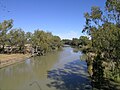
Yass River is a locality in the area of the Yass Valley Council, in New South Wales, Australia. It lies on both sides of both the Yass River to the northeast...
2 KB (101 words) - 16:07, 2 February 2021

of rivers of New South Wales (L–Z) Rivers of New South Wales "Yass River". Geographical Names Register (GNR) of NSW. Geographical Names Board of New South...
6 KB (284 words) - 13:16, 2 February 2023

is a hamlet in the Yass Valley Shire in New South Wales, Australia, about 90 km north-west of Canberra and 60 km south-west of Yass. It is in the Goodradigbee...
14 KB (1,297 words) - 06:59, 5 July 2024

Yass Valley Council is a local government area in the Southern Tablelands region of New South Wales, Australia. The area is located adjacent to the Hume...
11 KB (656 words) - 00:41, 16 September 2023

the Yass Town rail bridge over Yass River and the Yass Town Truss. It is owned by Transport Asset Holding Entity. It was added to the New South Wales State...
12 KB (1,103 words) - 09:17, 9 November 2023
discusses the rivers and hydrography of the state of New South Wales, Australia. The principal topographic feature of New South Wales is the series of...
21 KB (546 words) - 16:43, 19 December 2023

locality in the South West Slopes and Riverina regions of New South Wales, Australia in Yass Valley Shire. It is about 29 km west of Yass on the Hume Highway...
9 KB (778 words) - 04:27, 6 June 2024

Yass Valley Way is the main road which links Yass, New South Wales to the Hume Highway (to Sydney and Melbourne) and to the Barton Highway (to Canberra)...
2 KB (146 words) - 03:06, 16 January 2024
constructed in the 1990s Yass River, a river in the state of New South Wales, Australia Yass (software), a genomic local alignment tool Yass (music), a style...
975 bytes (178 words) - 03:42, 15 May 2023
Finley /ˈfɪnli/ is a town in the Riverina region of New South Wales, Australia. It is the largest town in the Berrigan Shire local government area. At...
7 KB (693 words) - 11:21, 10 April 2024

to rivers and oceans. The lake is believed to be more than a million years old. Originally, small streams drained its catchment into the Yass River, but...
25 KB (2,944 words) - 14:36, 4 May 2024

Wagga Wagga (redirect from Wagga Wagga CBD, New South Wales)
major regional city in the Riverina region of New South Wales, Australia. Straddling the Murrumbidgee River, with an urban population of more than 57,003...
86 KB (8,920 words) - 23:40, 3 July 2024

Highway that joins Sydney and Melbourne, between Goulburn and Yass in southern New South Wales, 255 kilometres (158 mi) southwest of Sydney and 79 kilometres...
17 KB (1,504 words) - 08:37, 9 March 2024

Weir (category Rivers)
across the width of a river that alters the flow characteristics of water and usually results in a change in the height of the river level. Weirs are also...
19 KB (2,295 words) - 18:30, 11 May 2024

Binya is a farming community in the centre of the Riverina area of New South Wales, Australia. The village is situated about 30 kilometres (19 mi) east...
5 KB (302 words) - 08:19, 6 July 2024

Tablelands of New South Wales, Australia in Yass Valley Shire. It is situated on the west bank of the Yass River, about 17 kilometres south of Gundaroo...
6 KB (408 words) - 10:46, 10 December 2023

in New South Wales, Australia, on the banks of the Snowy River between Melbourne and Sydney. The town is located at what was once an important river crossing...
10 KB (1,029 words) - 13:08, 5 January 2024

Goulburn (redirect from Goulburn, New South Wales)
regional city in the Southern Tablelands of New South Wales, Australia, approximately 195 kilometres (121 mi) south-west of Sydney and 90 kilometres (56 mi)...
46 KB (5,128 words) - 14:13, 3 July 2024
Barwon River, a perennial river that is part of the Murray–Darling basin, is located in the north-west slopes and Orana regions of New South Wales, Australia...
11 KB (868 words) - 03:56, 24 May 2024

of New South Wales. Retrieved 28 June 2009. O'Leary, Susan (11 July 2019). "Discover the lost city of Barren Jack on the Murrumbidgee River". Yass Tribune...
10 KB (530 words) - 08:38, 18 June 2024

of New South Wales, Australia in the Yass Valley Shire. It lies south-west of Yass on the northern side of Lake Burrinjuck on the Murrumbidgee River and...
3 KB (103 words) - 02:01, 13 June 2024
The New South Wales Legislative Assembly is elected from single-member electorates called districts, returning 93 members since the 1999 election. Prior...
32 KB (94 words) - 02:38, 12 June 2023

Murray-Darling basin, is located in the Snowy Mountains district of New South Wales, Australia. The river rises below Mount Morgan on the northern side of the Snowy...
6 KB (397 words) - 00:55, 5 March 2023

Vol. XXVI. New South Wales, Australia. 6 October 1899. p. 2. Retrieved 30 April 2024 – via National Library of Australia. "Bega News". The Yass Courier....
29 KB (3,533 words) - 07:02, 22 June 2024

first part of a list of rivers of New South Wales, Australia. With List of rivers of New South Wales (L–Z) it includes all 439 rivers, as of 7 June 2008,...
30 KB (94 words) - 17:20, 26 December 2022

second part of a list of rivers of New South Wales, Australia. With List of rivers of New South Wales (A–K) it includes all 439 rivers, as of 7 June 2008,...
31 KB (94 words) - 13:40, 28 April 2022

Riverina region of New South Wales. Tooma is in the valley of the Tooma River, not far from its confluence with the Murray River. The village is adjacent...
9 KB (357 words) - 21:35, 16 May 2023

Crookwell is a small town located in the Southern Tablelands of New South Wales, Australia, in the Upper Lachlan Shire. At the 2016 census, Crookwell...
14 KB (1,217 words) - 10:24, 24 June 2024

The South Western Slopes, also known as the South West Slopes, is a region predominantly in New South Wales, Australia. It covers the lower inland slopes...
15 KB (1,339 words) - 23:35, 2 March 2024