
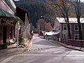
Yuba Pass is a mountain pass on State Route 49 in Sierra County in the U.S. state of California. The pass lies at an elevation of 6,710 ft (2,050 m) about...
2 KB (145 words) - 17:05, 13 October 2023

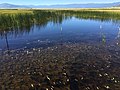
The Yuba River is a tributary of the Feather River in the Sierra Nevada and eastern Sacramento Valley, in the U.S. state of California. The main stem of...
25 KB (2,551 words) - 01:19, 27 March 2024
The Yuba County Five were a group of young men from Yuba County, California, United States, each with mild intellectual disabilities or psychiatric conditions...
29 KB (3,780 words) - 03:44, 18 July 2024

not being cultivated in the foothills of Yuba County. "Sierra Foothills" viticultural area encompasses Sierra Nevada's north-central foothill "belt", an...
8 KB (773 words) - 09:36, 30 April 2024

Placer County, California Plumas County, California Sierra County, California Tulare County, California Tuolumne County, California Yuba County, California...
11 KB (856 words) - 22:24, 20 July 2024

6 km) South Yuba River is a left-entering tributary of the Yuba River originating in the northern Sierra Nevada at Lake Angela in Nevada County about three...
9 KB (342 words) - 20:38, 22 July 2024

Donner Pass is a 7,056-foot-high (2,151 m) mountain pass in the northern Sierra Nevada, above Donner Lake and Donner Memorial State Park about 9 miles...
21 KB (2,125 words) - 08:14, 28 May 2024
vehicles only. Like most of the well-known Sierra Nevada passes, it lies on the Great Basin Divide. Here, the Middle Yuba River flows west to the Pacific Ocean...
5 KB (600 words) - 03:02, 10 April 2024
the border with Nevada. Sierra County was formed from parts of Yuba County in 1852. The county derives its name from the Sierra Nevada. Prior to the California...
49 KB (2,828 words) - 23:37, 13 May 2024

South Yuba River State Park is located along the South Fork of the Yuba River in the Sierra Nevada, within Nevada County, in Northern California. The park's...
4 KB (299 words) - 20:17, 24 December 2023

Bear River (Feather River tributary) (category Rivers of Yuba County, California)
is a tributary of the Feather River in the Sierra Nevada, winding through four California counties: Yuba, Sutter, Placer, and Nevada. About 73 miles...
21 KB (1,979 words) - 10:26, 1 October 2023
The Lost Sierra is the northern Sierra Nevada region in California in the United States. It encompasses the area of Plumas and Sierra Counties. The origin...
27 KB (3,699 words) - 11:52, 15 June 2024

County, California. Traditionally, the pass marks the northeast end of the Tehachapis and the south end of the Sierra Nevada range. The route is a principal...
6 KB (484 words) - 23:22, 24 March 2024

The northern third of the western Sierra is part of the Sacramento River watershed (including the Feather, Yuba, and American River tributaries), and...
70 KB (7,051 words) - 21:49, 24 July 2024

Interest Area Sierra County – south Yuba County – southwest Butte County – west Tehama County – northwest Shasta County – northwest Lassen County – northeast...
75 KB (3,289 words) - 07:45, 23 July 2024

Tioga Pass is a mountain pass in the Sierra Nevada mountain range of California. State Route 120 runs through it, and serves as the eastern entry point...
7 KB (519 words) - 21:21, 24 July 2024
Sierra Valley is an agricultural and livestock region. Tourism also contributes to the local economy. Entrance from the west is through Yuba Pass on...
4 KB (441 words) - 15:21, 26 February 2024

The Yuba–Bear Hydroelectric Project is a complex hydroelectric scheme in the northern Sierra Nevada in California, tapping the upper Yuba River and Bear...
19 KB (2,289 words) - 18:11, 28 March 2024

Ebbetts Pass (el. 8,736 ft or 2,663 m), named after John Ebbetts, is a high mountain pass through the Sierra Nevada range in Alpine County, California...
7 KB (775 words) - 18:58, 20 May 2024
Epilobium howellii (redirect from Yuba Pass Willowherb)
by the common names Yuba Pass willowherb and subalpine fireweed (though it is not a true fireweed). It is endemic to the High Sierra Nevada of California...
2 KB (220 words) - 08:39, 24 June 2022

Sherman Pass Road. One access route from the west is via SR 99 at Sierra Avenue (County Route J22) in Earlimart to Ducor, Avenue 56 (County Route J22)...
3 KB (257 words) - 08:47, 12 November 2023

Beckwourth Pass is the lowest mountain pass in the Sierra Nevada mountain range at an elevation of 5,221 feet (1,591 m). Beckwourth Pass is located at...
6 KB (537 words) - 11:57, 15 June 2024

The North Yuba River (also called the North Fork Yuba River) is the main tributary of the Yuba River in northern California in the United States. The river...
5 KB (213 words) - 18:33, 27 December 2018

Walker Pass (el. 5,250 ft (1,600 m)) is a mountain pass by Lake Isabella in the southern Sierra Nevada. It is located in northeastern Kern County, approximately...
7 KB (615 words) - 08:42, 4 February 2024
List of regions of California (section Sierra Nevada)
Area Yuba-Sutter area Sutter Buttes Sacramento-San Joaquin River Delta San Joaquin County San Francisco Bay Area East Bay Oakland–Alameda County Tri-Valley...
6 KB (377 words) - 04:44, 5 May 2024

Sonora Pass (el. 9,624 ft. / 2,933 m.) is a mountain pass in the Sierra Nevada in California. It is the second-highest pass with a road in California and...
11 KB (789 words) - 09:38, 2 July 2024

California State Route 49 (category Roads in Yuba County, California)
Mariposa County. State Route 49 then continues northward through the counties of Tuolumne, Calaveras, Amador, El Dorado, Placer, Nevada, Yuba, Sierra, and...
36 KB (2,930 words) - 12:41, 26 April 2024

Monitor Pass (el. 8,314 ft / 2,534 m) is a high mountain pass in California in the Sierra Nevada southeast of Lake Tahoe. It is traversed by State Route...
3 KB (321 words) - 02:52, 2 January 2023

Feather River (category Rivers of Yuba County, California)
Yuba City–Marysville. The Feather receives the Yuba River from the east at Yuba City and the Bear River from the east 15 miles (24 km) south of Yuba City...
32 KB (3,938 words) - 05:26, 4 April 2024
Fredonyer Pass, elevation 5,752 feet (1,753 m), is a high mountain pass in Lassen County, California, southwest of Susanville and southeast of Mount Lassen...
6 KB (551 words) - 18:32, 4 May 2024