
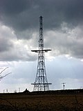
Coastal ocean dynamics applications radar (CODAR) is a type of portable, land-based, high frequency (HF) radar developed between 1973 and 1983 at NOAA's...
16 KB (2,309 words) - 10:41, 3 January 2024
portion of the HF band, that behaves more like low-VHF) Coastal ocean dynamics applications radar The high frequency band is very popular with amateur radio...
16 KB (1,842 words) - 17:27, 6 June 2024

capabilities for future floods. Coastal ocean dynamics Coastal ocean dynamics are important for many societal applications. They have smaller spatial and...
16 KB (1,695 words) - 03:17, 19 May 2024
The history of radar (where radar stands for radio detection and ranging) started with experiments by Heinrich Hertz in the late 19th century that showed...
151 KB (22,278 words) - 12:48, 26 July 2024

Weather radar, also called weather surveillance radar (WSR) and Doppler weather radar, is a type of radar used to locate precipitation, calculate its...
106 KB (12,803 words) - 19:17, 3 July 2024
Did you mean: Coastal ocean dynamics applications radar?...
2 KB (262 words) - 09:45, 4 March 2024
radar Type 726 Radar navigation radar Type 751 Radar navigation radar Type 752 Radar navigation radar Type 753 Radar navigation radar Type 756 Radar navigation...
115 KB (12,774 words) - 02:37, 26 July 2024

Bathymetry (redirect from Ocean mapping)
include coastal and oceanic landforms ranging from coastal estuaries and shorelines to continental shelves and coral reefs. Further out in the open ocean, they...
27 KB (3,776 words) - 14:08, 30 June 2024

T., Fake, P., Hall, P. et al. (2005). Integration of Coastal Ocean Dynamics Application Radar (CODAR) and Short-Term Predictive System (STPS) Surface...
12 KB (1,594 words) - 18:21, 9 December 2023

Lidar (redirect from Laser radar)
terrestrial, airborne, and mobile applications. Lidar is commonly used to make high-resolution maps, with applications in surveying, geodesy, geomatics...
130 KB (14,775 words) - 11:47, 24 July 2024
first Synthetic Aperture Radar (SAR) instrument. Seasat was only operational for a few months but, together with the Coastal Zone Color Scanner (CZCS)...
33 KB (4,474 words) - 01:32, 30 April 2024
El Niño/La Niña events, fisheries productivity, ocean currents, deep sea thermal vents, and coastal ecosystem health. The origins of NOAA Research date...
14 KB (1,474 words) - 13:06, 3 March 2024

Rogue wave (category Fluid dynamics)
since been confirmed by video and photographs, satellite imagery, radar of the ocean surface, stereo wave imaging systems, pressure transducers on the...
111 KB (12,315 words) - 20:25, 24 July 2024

Wind wave (redirect from Ocean wave)
dynamics of the upper ocean (2nd ed.). Cambridge University Press. ISBN 978-0-521-29801-8. Holthuijsen, Leo H. (2007). Waves in oceanic and coastal waters...
49 KB (6,139 words) - 18:26, 8 May 2024

Remote sensing (redirect from Applications of remote sensing)
wavelength of ocean waves, the altimeters measure wind speeds and direction, and surface ocean currents and directions. Ultrasound (acoustic) and radar tide gauges...
63 KB (7,739 words) - 02:49, 7 July 2024
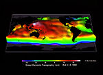
Ocean surface topography or sea surface topography, also called ocean dynamic topography, are highs and lows on the ocean surface, similar to the hills...
15 KB (1,731 words) - 06:27, 17 February 2024
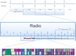
Radio spectrum (redirect from IEEE radar bands)
frequencies that vary by area. Radar applications use relatively high power pulse transmitters and sensitive receivers, so radar is operated on bands not used...
44 KB (2,908 words) - 15:59, 24 July 2024

wide range of topics, including ecosystem dynamics; ocean currents, waves, and geophysical fluid dynamics; plate tectonics and seabed geology; and fluxes...
226 KB (32,647 words) - 05:54, 11 July 2024
Wind stress (category Fluid dynamics)
oceanography and fluid dynamics, the wind stress is the shear stress exerted by the wind on the surface of large bodies of water – such as oceans, seas, estuaries...
24 KB (3,206 words) - 14:50, 27 March 2024
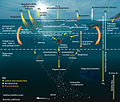
Marine food web (redirect from Ocean food web)
visible in ocean colour imagery. Having the ability to detect these "invisible" surfactant-associated bacteria using synthetic aperture radar has immense...
158 KB (16,548 words) - 02:36, 22 June 2024

Sea level rise (redirect from Ocean levels)
inundation of 29% of coastal resorts in the Caribbean. A further 49–60% of coastal resorts would be at risk from resulting coastal erosion. Oceans portal Climate...
215 KB (22,577 words) - 23:51, 24 July 2024

Underwater exploration (section Coastal waters)
and remote visual observation of what is there. The oceans can be divided into deep ocean and coastal waters. Inland waters are mostly fresh, and consist...
38 KB (4,737 words) - 19:27, 22 July 2024

waterways, while the National Oceanic and Atmospheric Administration (NOAA) performs the same role for ocean waterways. Coastal bathymetry data is available...
9 KB (1,929 words) - 14:07, 25 May 2024

terrestrial ecosystem structure, ocean ecosystem structure, aquatic-coastal biogeochemistry, soil moisture, ocean surface winds and currents, vegetation-snow-surface...
20 KB (1,999 words) - 11:46, 13 January 2024

Soloviev; Roger Lukas (2006). The near-surface layer of the ocean: structure, dynamics and applications. シュプリンガー・ジャパン株式会社. p. xi. Bibcode:2006nslo.book.....S...
41 KB (4,598 words) - 08:07, 18 July 2024

Automatic identification system (section Applications)
Bibcode:2019OGeo...11...44T. doi:10.1515/geo-2019-0044. AIS Currents & Ocean Dynamics 2.0 ocean current mapping resources by e-Odyn AIS research resources a list...
89 KB (11,143 words) - 10:35, 17 June 2024
Remote sensing in geology (redirect from Remote sensing applications in geology)
could be derived from radar altimetry and InSAR methods, for instance in the mapping of Venus. As an example of planetary applications using remote sensing...
62 KB (7,081 words) - 03:56, 24 June 2024
spectrum with HF radar (NERC) Applications of computational geometry to the analysis of directional ocean wave spectra measured by HF radar (EPSRC) A non-linear...
4 KB (419 words) - 16:35, 25 October 2023

Tropical cyclone (redirect from List of depressions over the North Indian Ocean)
dependence of the dry air effect on tropical cyclone development". Dynamics of Atmospheres and Oceans. 87: 101102. Bibcode:2019DyAtO..8701102S. doi:10.1016/j.dynatmoce...
210 KB (20,555 words) - 04:46, 26 July 2024

disseminate information about the atmospheric, oceanic, and hydrologic sciences, and advance technologies, applications, and services related to them. anabatic...
187 KB (21,500 words) - 23:23, 1 June 2024