
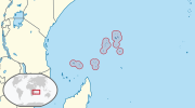
-12.167; 44.250 The Comoros archipelago consists of four main islands aligned along a northwest–southeast axis at the north end of the Mozambique Channel...
12 KB (1,408 words) - 20:32, 12 June 2024
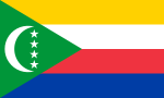
The Comoros, officially the Union of the Comoros, is an archipelagic country made up of three islands in Southeastern Africa, located at the northern end...
93 KB (9,473 words) - 13:43, 26 August 2024

The Comoros forests is a terrestrial ecoregion which covers the Comoro Islands, which lie in the Mozambique Channel between Madagascar and East Africa...
13 KB (1,566 words) - 21:34, 24 March 2024
The following outline is provided as an overview of and topical guide to Comoros: Comoros – sovereign island nation located in the Indian Ocean off the...
13 KB (947 words) - 20:51, 2 December 2023

The Comoro Islands or the Comoros (Comorian: Komori; Arabic: جزر القمر, romanized: Juzur al-Qomor; French: Les Comores) are an archipelago of volcanic...
23 KB (2,931 words) - 15:36, 25 July 2024

romanized: Mūrūnī) is the largest city, federal capital, and seat of the government of the Union of the Comoros, a sovereign archipelago nation in the Indian Ocean...
20 KB (1,888 words) - 07:30, 21 August 2024

The Politics of the Union of the Comoros take place in a framework of a unitary presidential republic, whereby the President of the Comoros is both head...
23 KB (2,862 words) - 04:03, 16 July 2024

The economy of the Comoros is based on subsistence agriculture and fishing. Comoros has inadequate transportation links, a young and rapidly increasing...
28 KB (3,196 words) - 02:30, 7 April 2024
Comoros Flag of the Comoros Foreign relations of Comoros Geography of Comoros Hamada Madi History of Comoros Ikililou Dhoinine Islam in Comoros LGBT rights...
2 KB (169 words) - 15:00, 31 July 2022
of the Comoros' few hotels. Travel and Tourism in Comoros, Euromonitor Boniface, Brain G.; Christopher P. Cooper (2001). Worldwide Destinations: The Geography...
2 KB (187 words) - 05:27, 4 June 2024
Badgini (category Geography of the Comoros)
the island of Grande Comore in present day Comoros. It was independent until 1886, when Sultan Said Ali bin Said Omar of Bambao made it a part of the...
523 bytes (50 words) - 18:32, 14 March 2023

Glorioso Islands (redirect from Geography of the Glorioso Islands)
are geographically part of the Comoro Islands between the French overseas region of Mayotte and the nation of Madagascar. The archipelago consists of two...
8 KB (757 words) - 04:12, 6 July 2024

Mozambique. Mayotte is part of the Comoro Islands, and like them is the result of a former geological hot spot, the oldest of the Comoros archipelago, formed...
3 KB (237 words) - 20:35, 12 June 2024
The Comoros island chain in the Mozambique Channel is the result of the rifting of Madagascar away from Africa as well as "hotspot" mantle plume activity...
3 KB (341 words) - 09:07, 14 July 2024

Anjouan (redirect from Anjouan Island, Comoros)
an autonomous volcanic island in the Comoro Islands in the southwestern Indian Ocean, part of the Union of the Comoros. It is known in Shikomori as Ndzuani...
28 KB (3,386 words) - 07:04, 21 August 2024
Time in Comoros is given by a single time zone, officially denoted as East Africa Time (EAT; UTC+03:00). Comoros does not observe daylight saving time...
2 KB (156 words) - 23:19, 10 June 2024

Change[permanent dead link]. Banjul, November 2012, p. 32. The World Factbook: The Gambia. Chapter Geography and map. On a 1966 map, two points close to Jah Kunda...
7 KB (790 words) - 20:30, 7 July 2024

five general geographical regions: the east coast, the Tsaratanana Massif, the Central Highlands, the west coast, and the southwest. The highest elevations...
30 KB (2,871 words) - 17:11, 13 August 2024

Mayotte (redirect from French occupied Comoros)
was the capital of Mayotte (and earlier the capital of all the colonial Comoros) until 1977, when the capital was relocated to Mamoudzou on the main...
69 KB (7,077 words) - 13:11, 28 August 2024
against the Somali Piracy Problem." (2012). "Geography of Seychelles - Archive - Seychelles Nation". www.nation.sc. Retrieved 2020-05-26. "Geography of Seychelles...
32 KB (2,004 words) - 16:19, 24 July 2024

area of 13 million km2. It extends from Morocco in the west, southward to the Comoros, eastward to Somalia, and northward to Iraq. The geography of each...
8 KB (540 words) - 20:02, 11 July 2024
of the Caribbean, Central America, and South America. The UN geoscheme includes the British Indian Ocean Territory (Chagos Archipelago), the Comoros,...
21 KB (371 words) - 05:46, 30 June 2024
National Geographic Video is an educational video series founded by the National Geographic Society. "All Seasons". TheTVDB. Whip Media....
114 KB (19 words) - 22:51, 2 July 2024

the sleeping sickness would kill their livestock). Africa portal List of national parks in Africa Outline of Africa#Geography of Africa The Horn of Africa...
37 KB (4,495 words) - 12:51, 6 July 2024

Southern Africa (redirect from Geography of Southern Africa)
the Comoros, Eswatini, Lesotho, Madagascar, Malawi, Mauritius, Mozambique, Namibia, South Africa, Zambia, and Zimbabwe. In cultural geography, the island...
37 KB (3,955 words) - 19:51, 4 August 2024

Chad to the northeast. Notable geographical features in Nigeria include the Adamawa Plateau, Mambilla Plateau, Jos Plateau, Obudu Plateau, the Niger River...
56 KB (3,767 words) - 23:23, 19 August 2024
This is a list of protected areas of the Comoros. UNEP-WCMC (2021). Protected Area Profile for Comoros from the World Database of Protected Areas. Accessed...
2 KB (30 words) - 08:29, 30 March 2024

000 The geography of Egypt relates to two regions: North Africa and West Asia. Egypt has coastlines on the Mediterranean Sea, the River Nile, and the Red...
20 KB (2,850 words) - 07:18, 24 August 2024

with water. The most popular geographic fact about Lesotho, apart from its status as an enclave, is that it is the only independent state in the world that...
19 KB (1,651 words) - 06:39, 21 August 2024

Fournaise (2,631 m) on the southeastern coast, which is an active volcano. Wikimedia Commons has media related to Geography of Réunion. 21°06′S 55°36′E...
3 KB (220 words) - 20:35, 12 June 2024