
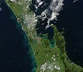
Kaipara Harbour is a large enclosed harbour estuary complex on the north western side of the North Island of New Zealand. The northern part of the harbour...
35 KB (3,781 words) - 07:46, 30 June 2024

Reserve Boards. Kaipara District is located in the rolling hills around the northern shores of the Kaipara Harbour, a large natural harbour open to the Tasman...
13 KB (1,221 words) - 03:55, 2 June 2024

Helensville (category Populated places around the Kaipara Harbour)
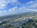
(25 mi) northwest of Auckland, close to the southern extremity of the Kaipara Harbour. State Highway 16 passes through the town, connecting it to Waimauku...
36 KB (4,077 words) - 00:49, 18 June 2024

Ocean power in New Zealand (section Kaipara Harbour)
the entrance to the Kaipara. Other potential locations include the Manukau and Hokianga Harbours, and French Pass. The harbours produce currents up to...
28 KB (3,164 words) - 08:39, 21 January 2024
Parliamentary electorate Kaipara District, a local government division in New Zealand Kaipara Harbour, in northern New Zealand Kaipara River, in northern New...
338 bytes (78 words) - 10:16, 9 October 2020

eastern Kaipara Harbour has been settled by Māori since the 13th or 14th centuries, who utilised the inland forests and marine resources of the Kaipara Harbour...
26 KB (2,757 words) - 02:42, 18 July 2024

50miles 2 1 The Mangapai portage connected the Kaipara Harbour in the west to the Whangārei Harbour in the east. The portage extended from the Wairoa...
26 KB (2,609 words) - 23:27, 23 June 2024
Auckland Peninsula between Bream Bay and the upper branches of the Kaipara Harbour. It is most notable as the scene of a 1963 bus crash which killed 15...
1 KB (116 words) - 12:15, 17 July 2024

Pouto Peninsula (category Populated places around the Kaipara Harbour)
The Pouto Peninsula is a landform on the northern Kaipara Harbour in Northland, New Zealand. The Peninsula runs in the north west to south east direction...
11 KB (1,460 words) - 02:55, 26 December 2023
The Kaipara tidal power station was a proposed tidal power project to be located in the Kaipara Harbour. The project was being developed by Crest Energy...
6 KB (510 words) - 11:21, 4 May 2024

in contrast, they are fewer but larger. Kaipara Harbour is the country's largest, and the Hokianga Harbour, further north, is of historical significance...
12 KB (1,356 words) - 22:56, 13 April 2024
Riverhead, New Zealand (category Populated places around the Waitematā Harbour)
Tōangaroa, a portage where waka could be hauled between the Kaipara Harbour and the Waitematā Harbour. European settlement began in 1844 when a kauri mill was...
19 KB (1,710 words) - 06:31, 18 July 2024

southern Australia, including Tasmania, and south of East Cape and Kaipara Harbour in New Zealand, at depths of 0–200 m (0–656 ft). Despite several of...
9 KB (1,104 words) - 19:41, 17 January 2024

government. On the mainland, the region extends from the mouth of the Kaipara Harbour in the north across the southern stretches of the Northland Peninsula...
11 KB (1,037 words) - 19:38, 3 July 2024

which allowed waka to be hauled overland between the Mangawhai Harbour and the Kaipara Harbour, via the Kaiwaka River, Hakaru River and Otamatea River. 41...
7 KB (591 words) - 20:00, 17 February 2024

entering the southern Kaipara Harbour. Other major tributaries are the Ararimu, Ahukuramu, Waimauku and Waipatukahu streams. The lower Kaipara River winds through...
5 KB (226 words) - 03:21, 21 April 2024
Whangarei Harbour on the east coast. By the time of European settlement in New Zealand, Ngāti Whātua's territory was around the Kaipara Harbour and stretching...
12 KB (1,290 words) - 09:49, 15 June 2024

House. Matakana Island in Tauranga Harbour Opahekeheke Island in the Kaipara Harbour Puddingstone Island in Otago Harbour Rabbit Island, Bells Island, and...
10 KB (953 words) - 15:33, 19 May 2024

acres (4.0 km2) sculpture park at Gibbs Farm, which is located on Kaipara Harbour on New Zealand's North Island, 50 kilometres (31 mi) north of Auckland...
7 KB (504 words) - 06:44, 10 July 2024
Kaiikanui River (category Kaipara Harbour catchment)
The Kaiikanui River is a river of Northland, New Zealand. List of rivers of New Zealand "Place name detail: Kaiikanui River". New Zealand Gazetteer. New...
898 bytes (51 words) - 02:00, 13 April 2024

the massive Kaipara Harbour in the south, which Northland shares with the Auckland Region, and the convoluted inlets of the Hokianga Harbour. The east coast...
30 KB (2,684 words) - 08:49, 14 June 2024
Māhuhu-ki-te-rangi explored the upper reaches of the North Island north of the Kaipara Harbour during early Māori settlement of New Zealand. Its crew explored Whangaroa...
3 KB (357 words) - 23:42, 15 March 2024
and it was named Kaipara ki Mahurangi instead. The electorate draws its name from two areas of geographic importance, the Kaipara Harbour, in the west of...
12 KB (329 words) - 02:59, 9 June 2024

Ngāti Whātua fought over the area when the latter settled south of the Kaipara Harbour. Muriwai became known as the border between Te Kawerau ā Maki and Ngāti...
20 KB (1,940 words) - 00:47, 6 July 2024
Kaiwaka (category Kaipara District)
the Wairau River to form the Otamatea River, which drains into the Kaipara Harbour. State Highway 1 passes through Kaiwaka. Wellsford is 20 kilometres...
14 KB (1,784 words) - 03:22, 2 May 2024

810 kHz in Auckland, 107.0 MHz in Whitianga and Whangamatā, 107.3 MHz in Kaipara Harbour, 88.2 MHz in Suva and Nadi, 100.0 MHz in Bairiki and Tarawa, 101.1 MHz...
111 KB (8,790 words) - 10:31, 14 July 2024

Paparoa (redirect from Otamatea (Kaipara District))
Creek to the south, which joins the Arapaoa River which is part of the Kaipara Harbour. State Highway 12 passes through Paparoa. Matakohe is 6 km to the south...
11 KB (1,353 words) - 02:52, 26 December 2023
the Kaipara Tidal Power Station. Other potential locations include the Manukau and Hokianga Harbours, and Te Aumiti / French Pass. The harbours produce...
92 KB (9,177 words) - 06:22, 28 June 2024

holiday homes close to Auckland. The Kaipara Harbour and surrounding area is within the tribal area of Ngāti Whātua o Kaipara, which has five marae in the area...
3 KB (223 words) - 07:29, 21 July 2024
end of Bream Bay in the east to the Otamatea River (an arm of the Kaipara Harbour) in the west. Though not of great height (reaching only some 450 metres)...
4 KB (324 words) - 05:46, 13 April 2024