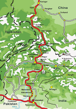
650°E / 35.600; 74.650 The Karakoram Highway (Urdu: شاہراہ قراقرم, Śāhirāh-i Qarāquram), also known as the KKH, National Highway 35 (Urdu: قومی شاہراہ ۳۵)...
33 KB (3,174 words) - 12:12, 28 June 2024

887-kilometre-long (551 mi) National Highway 35 (N-35), which forms the Pakistani portion of the Karakoram Highway (KKH). The KKH spans the 806-kilometre-long...
16 KB (1,797 words) - 16:22, 18 May 2024
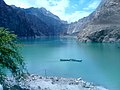
Attabad Lake (section Karakoram Highway realignment)
considerable stretch measuring over 19 kilometers (12 miles) of the Karakoram Highway, a pivotal transportation artery in the region. The lake reached 21...
14 KB (1,355 words) - 15:22, 6 July 2024
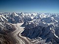
The Karakoram (/ˌkɑːrəˈkɔːrəm, ˌkær-/) is a mountain range in the Kashmir region spanning the border of Pakistan, China, and India, with the northwestern...
28 KB (2,512 words) - 04:51, 14 July 2024

Sust (section Karakoram Highway)
800 meters above sea level, Sost is the last Pakistani town on the Karakoram Highway before the Chinese border. The town plays an important role in the...
5 KB (445 words) - 16:15, 30 June 2024

include the famous Grand Trunk Road, Indus Highway, Karakoram Highway and Makran Coastal Highway. All national highways in Pakistan are pre-fixed with the letter...
11 KB (207 words) - 17:00, 31 October 2023
of the Karakoram Highway. It builds civil and military infrastructure for the Government of Pakistan and the Pakistan Armed Forces. Highways and roads...
7 KB (652 words) - 18:43, 9 November 2023

Upal (section Karakoram Highway)
a town in Shufu County in Western Xinjiang, China. Upal is on the Karakoram Highway, which follows the old Silk Road route from China to Pakistan. Travelling...
3 KB (221 words) - 21:36, 18 October 2023

Arabian Sea date back to the 1950s, and motivated construction of the Karakoram Highway beginning in 1959. Chinese interest in Pakistan's deep-water harbor...
277 KB (28,588 words) - 12:10, 6 July 2024

Tourism in Gilgit-Baltistan (section Karakoram Highway)
addition, several high-altitude lakes in Gilgit-Baltistan. The Karakoram Highway is the major highway of Gilgit-Baltistan, which connects the region with the...
9 KB (947 words) - 04:34, 12 July 2024

Tashkurgan (section Karakoram Highway)
begins just north of the Khunjerab Pass and flows north along the Karakoram Highway to Tashkurgan. Just north of Tashkurgan it turns east and flows through...
32 KB (2,874 words) - 18:29, 29 May 2024

lakes, and glaciers in the area. Landslides on the Karakoram Highway are very common. The Karakoram Highway connects Gilgit to Tashkurgan Town, Kashgar, China...
126 KB (11,764 words) - 13:19, 2 July 2024

1930s by the Soviet Union. In 2000s Pamir Highway was connected with China and Karakoram Highway. The Pamir Highway is designated as route M-41 over much...
15 KB (1,557 words) - 18:21, 26 June 2023

highway The Karakoram Highway, between Pakistan and China, is at an altitude of 4,693 metres (15,397 ft).[citation needed] Highest national highway National...
48 KB (4,911 words) - 16:43, 12 July 2024

the Gilgit Baltistan region of Northern Pakistan. Located along the Karakoram Highway, Passu is a renowned tourist destination. The village is celebrated...
7 KB (482 words) - 12:02, 13 July 2024
bypass for the Karakoram Highway (N–35) and is popular amongst tourists who visit Naran and its surrounding region. Karakoram Highway Naran Valley Gilgit–Baltistan...
2 KB (103 words) - 13:56, 28 January 2022

Kaghan Valley, connecting it via the Thak Nala with Chilas on the Karakoram Highway (KKH). Babusar Top is the highest point in Kaghan Valley that can...
6 KB (550 words) - 11:10, 12 July 2024

discovered by Europeans until 1900. However, the building of the Karakoram Highway from Pakistan to China, which runs past nearby Tashkurgan and Karakul...
5 KB (507 words) - 01:24, 28 April 2024

serves as the Chinese part of Karakoram Highway. Wikimedia Commons has media related to China National Highway 314. China National Highways Kulma Pass...
2 KB (120 words) - 20:23, 23 June 2023

injuries and effectively blocked about 26 kilometres (16 mi) of the Karakoram Highway. The new lake extends 30 kilometres (19 mi) and rose to a depth of...
23 KB (2,307 words) - 01:26, 11 July 2024

frontier. In modern times, Hasan Abdal lies at the intersection of the Karakoram Highway, and the M1 Motorway. As part of the multibillion-dollar China-Pakistan...
12 KB (1,205 words) - 12:54, 10 June 2024

Khunjerab Pass (category Mountain passes of the Karakoram)
border crossing globally and serving as the highest point along the Karakoram Highway. The construction of the road across this pass was completed in 1982...
9 KB (897 words) - 14:28, 24 June 2024

River. It is part of the Silk Road, connected by the Karakoram Highway and N-90 National Highway to Islamabad and Peshawar in the southwest, via Hazara...
20 KB (1,923 words) - 04:49, 28 January 2024
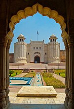
help the country's tourism industry. The sites included Lahore, the Karakoram Highway, Karimabad and Lake Saiful Muluk. To promote the country's cultural...
60 KB (5,184 words) - 19:08, 12 July 2024

are the lowlands of the Tarim Basin and the Taklamakan Desert. The Karakoram Highway passes very close to both peaks as well as Karakul Lake, from which...
7 KB (736 words) - 03:46, 1 July 2024

the first town after Naran is Batakundi. It is situated along the Karakoram Highway (KKH) and is a stop for jeeps. It is the first destination on the...
4 KB (257 words) - 22:33, 7 July 2024

Travel the Karakoram Highway (Backpacker's Guide)". 7 April 2020. "Major cities, towns, valleys and villages along the Karakorum Highway". "سی پیک سیاحت:...
12 KB (826 words) - 22:24, 25 June 2024

Transport portal Expressways of China Transport in China Tarim Desert Highway Karakoram Highway [关注国家公路网]公路网规划支撑中国梦. Archived from the original on 2013-12-02...
76 KB (916 words) - 23:13, 22 March 2023

Raikot Bridge is a road bridge situated on the Karakoram Highway, spanning the River Indus. It is the gateway to Nanga Parbat base camp, in Diamer District...
5 KB (431 words) - 22:26, 10 March 2024

Encyclopædia Britannica 4 October 2014. Singh, Sarina (2004). Pakistan & the Karakoram Highway (6th ed.). Lonely Planet. p. 112. ISBN 978-0-86442-709-0. Minahan...
13 KB (1,341 words) - 10:19, 12 June 2024