
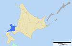
Kuromatsunai (黒松内町, Kuromatsunai-chō) is a town located in Shiribeshi, Hokkaido, Japan. As of 24 May 2020 the town had an estimated population of 2,739...
9 KB (279 words) - 22:10, 4 October 2024

Kuromatsunai Station (黒松内駅, Kuromatsunai-eki) is a railway station in Kuromatsunai, Suttsu District, Hokkaidō, Japan. Hokkaido Railway Company Hakodate...
4 KB (116 words) - 07:43, 3 February 2024

The Kuromatsunai Shindō (黒松内新道) is a 5.1-kilometer-long (3.2 mi) spur route of the Dō-Ō Expressway in Kuromatsunai, Hokkaido. It is owned and operated...
4 KB (241 words) - 19:12, 16 October 2024

Kuriyama 栗山町 203.84 12,365 Sorachi Subprefecture Yūbari District Town Kuromatsunai 黒松内町 345.65 2,739 Shiribeshi Subprefecture Suttsu District Town Kushiro...
140 KB (7,517 words) - 07:48, 11 October 2024

and a density of 16.60 persons per km2. The total area is 440.83 km2. Kuromatsunai Suttsu 42°42′07″N 140°19′37″E / 42.702°N 140.327°E / 42.702; 140.327...
825 bytes (64 words) - 19:54, 17 July 2024

Subprefecture Toyoura Oshima Subprefecture Yakumo Shiribeshi Subprefecture Kuromatsunai Shimamaki 1864: The village of Oshamambe was founded. 1906: Oshamambe...
8 KB (233 words) - 22:00, 4 October 2024
Tōbetsu 当別町 Hokkaido Ishikari 422.86 Suttsu 寿都町 Hokkaido Suttsu 95.24 Kuromatsunai 黒松内町 Hokkaido Suttsu 345.65 Rankoshi 蘭越町 Hokkaido Isoya 449.78 Niseko...
148 KB (122 words) - 00:34, 2 May 2024

Tertiary period tuff and mudstone); and the centre portion consists of Kuromatsunai strata (Tertiary period sand-like mudstone). Igneous intrusions and faults...
25 KB (2,721 words) - 12:44, 17 October 2024

Station - The 48 km line to Setana opened in 1929/32, closing in 1987. Kuromatsunai Station - The local government built the line to the port of Suttsu (17 km)...
36 KB (2,464 words) - 03:39, 3 September 2024

Imakane Setana Oshima Subprefecture Oshamambe Shiribeshi Subprefecture Kuromatsunai Suttsu 1906: The village of Higashishimamaki and the village of Nishishimamaki...
3 KB (143 words) - 21:50, 4 October 2024

Nitonupuri Iburi Subprefecture Toyoura Shiribeshi Subprefecture Iwanai Kuromatsunai Kutchan Niseko Suttsu 1909: Minamishiribeshi became a Second Class Village...
8 KB (225 words) - 21:57, 4 October 2024
Peninsula is separated from the rest of the island of Hokkaido by the Kuromatsunai Depression - an area of intensive agricultural development that forms...
4 KB (424 words) - 19:18, 16 October 2024
Furuu District Village Kimobetsu 喜茂別町 189.51 2,286 Abuta District Town Kuromatsunai 黒松内町 345.65 2,739 Suttsu District Town Kutchan (capital) 倶知安町 261.24...
7 KB (115 words) - 12:20, 16 April 2024
E30 Seto-Chūō E76 Nishiseto MLIT E4A Kamikita E5 Hakodate Shindō E5A Kuromatsunai Shindō E7 Akita E9 San'in Kinki E25 Meihan E29 Tottori E38 Dōtō E38/E44...
23 KB (2,178 words) - 17:16, 14 October 2024
Hakodate - Nanae - Mori - Yakumo - Oshamanbe Shiribeshi Subprefecture Kuromatsunai - Rankoshi - Niseko - Kyōwa - Niki - Yoichi - Otaru Ishikari Subprefecture...
17 KB (400 words) - 03:05, 9 August 2024
merged with Suttsu District's Kuromatsunai Village and part of Tarukishi Village to create Sanwa Village (now Kuromatsunai Town) Isoya (磯屋郡, later respelled...
13 KB (1,053 words) - 17:28, 26 September 2024
(Miyagi) 黒松駅 (宮城県)(くろまつ) Kuromatsu Station (Shimane) 黒松駅 (島根県)(くろまつ) Kuromatsunai Station 黒松内駅(くろまつない) Kurosaka Station 黒坂駅(くろさか) Kurosaki Station 黒崎駅(くろさき)...
129 KB (6 words) - 22:46, 21 August 2024

Beech Forests at the Northern Boundary 北限のブナ林 Hokugen no buna bayashi Kuromatsunai The Oshima Peninsula marks the northern limit of this temperate zone...
53 KB (309 words) - 17:29, 1 August 2024

flows in the middle of the town and divides the town into east and west. Kuromatsunai Rankoshi Shimamaki Suttsu has a humid continental climate (Köppen climate...
8 KB (326 words) - 21:43, 4 October 2024

daily. National Route 5 Roadside station Kuromatsunai Kuromatsunai Shindo Kuromatsunai I.C. Mount Kuromatsunai Miyawaki, Shunzo (June 1993). Harada, Katsumasa...
3 KB (78 words) - 14:11, 13 October 2024
Shakotan District Shakotan Shimamaki District Shimamaki Suttsu District Kuromatsunai Suttsu Yoichi District Akaigawa Niki Yoichi Akabira Ashibetsu Bibai Fukagawa...
16 KB (575 words) - 19:55, 9 February 2024
National Route 230 concurrency Kuromatsunai 14.2 8.8 Hokkaido Route 266 west – to Kuromatsunai Shindō, central Kuromatsunai Toyoura 23.5 14.6 Hokkaido Route...
10 KB (555 words) - 13:32, 1 October 2024
(ZVV), a regional railway line of the Zürich S-Bahn Neppu Station, in Kuromatsunai, Suttsu District, Hokkaido, Japan County Route S29 (California) County...
1 KB (176 words) - 04:17, 21 January 2023

Toyoura Interchange National Route 37 159.4 12 Kuromatsunai Junction Kuromatsunai Shindō west 177.6 Kuromatsunai PA Shizukari Parking Area 187.9 Oshamanbe...
25 KB (857 words) - 21:26, 13 December 2023
Microporina (Bryozoa, Cheilostomata) from the Pleistocene Setana Formation at Kuromatsunai, Hokkaido, Japan". Paleontological Research. 27 (3): 245–260. doi:10...
290 KB (25,442 words) - 16:43, 16 October 2024

For Imakane and Setana For Yakumo, Mori, and Hakodate Niseko Bus For Kuromatsunai and Suttsu List of railway stations in Japan "Oshamambe Station information"...
4 KB (203 words) - 06:57, 25 April 2024
Ticino, Switzerland S30 (ZVV), a railway line in Zürich, Switzerland Kuromatsunai Station, in Suttsu District, Hokkaido, Japan S 30 (keelboat), a sailboat...
1 KB (222 words) - 21:45, 2 December 2022

merged with Suttsu District's Kuromatsunai Village and part of Tarukishi Village to form Sanwa Village (now Kuromatsunai Town) Isoya (磯屋郡, later respelled...
5 KB (501 words) - 06:33, 16 March 2023

核ごみ調査受け入れで北海道神恵内村の高橋村長". Tokyo Shimbun. "喜茂別町の歴史". Kimobetsu. "町の基本情報". Kuromatsunai. "北海道黒松内町との姉妹市町提携盟約調印式". Seiyo. Archived from the original on 12 April...
187 KB (4,266 words) - 00:41, 18 September 2024

station name when arranged in the Gojuon order. National Route 5 Mount Kuromatsunai Niseko Bus "Warabidai" bus stop List of railway stations in Japan Ishino...
4 KB (352 words) - 07:42, 29 June 2024