a list of secondary highways in Algoma District, most of which serve as logging roads or provide access to isolated and sparsely populated areas in the...
35 KB (2,703 words) - 03:04, 20 June 2024
This is a list of secondary highways in Cochrane District, most of which serve as logging roads, mine and dam access roads, or provide access to isolated...
18 KB (1,354 words) - 10:20, 11 August 2022
This is a list of secondary highways in Thunder Bay District, most of which serve as logging roads or provide access to the isolated and sparsely populated...
30 KB (1,905 words) - 15:53, 3 September 2023
is a list of secondary highways in Kenora District, most of which provide access to isolated and sparsely populated areas in the Kenora District of northwestern...
30 KB (2,153 words) - 02:37, 7 July 2023

District is a district in Northeastern Ontario in the Canadian province of Ontario. It was created in 1894 from townships of eastern Algoma District and...
12 KB (958 words) - 22:03, 7 May 2024

Algoma District is a district and census division in Northeastern Ontario in the Canadian province of Ontario. The name was created by an American ethnologist...
17 KB (1,186 words) - 11:01, 30 April 2024
is a list of secondary highways in Rainy River District, most of which serve isolated and sparsely populated areas in the Rainy River District of northwestern...
8 KB (525 words) - 15:52, 3 September 2023
This is a list of secondary highways in Manitoulin District, which serve the isolated and sparsely populated areas in the Manitoulin District of Ontario...
11 KB (764 words) - 00:18, 19 June 2024
This is a list of secondary highways in Timiskaming District, most of which serve as logging roads or provide access to the isolated and sparsely populated...
17 KB (982 words) - 16:49, 10 April 2023

6 kilometres (3.5 mi) in length and follows an older alignment of Highway 17 east of Blind River and near the village of Algoma Mills, between the Canadian...
6 KB (562 words) - 20:27, 12 May 2021
a list of secondary highways in Sudbury District, most of which serve as logging roads or provide access to provincial parks and isolated areas in the...
7 KB (491 words) - 20:51, 31 March 2022
This is a list of secondary highways in Parry Sound District, many of which provide access to isolated settlements and recreational properties within...
25 KB (1,585 words) - 21:30, 1 September 2022
This is a list of secondary highways in Nipissing District, many of which serve as logging roads or provide access to Algonquin Park and sparsely populated...
13 KB (782 words) - 22:20, 31 March 2021

towns in Unorganized Algoma District, notably Searchmont. The route is remote, ending at a mine access road 14.2 kilometres (8.8 mi) north of Highway 556...
6 KB (664 words) - 19:05, 31 August 2022

following is a list of former primary state highways completely or mostly within the Salem District (VDOT District 2) of the U.S. state of Virginia. State...
32 KB (4,777 words) - 16:31, 9 February 2024

Secondary Highway 638, commonly referred to as Highway 638, is a provincially maintained secondary highway located in the District of Algoma in the Canadian...
14 KB (1,366 words) - 23:10, 29 July 2023
Provincial highways in Ontario include all roads maintained by the Ministry of Transportation as part of the Ontario Provincial Highway Network. Although...
118 KB (2,499 words) - 00:21, 19 June 2024
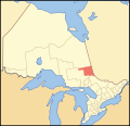
a district and census division in Northeastern Ontario in the Canadian province of Ontario. The district was created in 1912 from parts of Algoma, Nipissing...
12 KB (509 words) - 04:01, 7 January 2024
King's Highway 108, commonly referred to as Highway 108, is a provincially maintained highway in the Canadian province of Ontario. Located in the Algoma District...
9 KB (843 words) - 15:45, 22 May 2024

Northeastern Ontario (category Geography of Northern Ontario)
consists of the districts of Algoma, Sudbury, Cochrane, Timiskaming, Nipissing and Manitoulin. For some purposes, Parry Sound District and Muskoka District Municipality...
10 KB (466 words) - 16:00, 18 September 2023
as part of the King's Highway, secondary highways, and tertiary roads. Components of the system—comprising 16,900 kilometres (10,500 mi) of roads and...
119 KB (11,363 words) - 08:06, 29 May 2024
King's Highway 129, commonly referred to as Highway 129, is a provincially maintained highway in the Canadian province of Ontario. Located in the Algoma and...
15 KB (1,173 words) - 11:05, 20 August 2022

All of these secondary roads were taken into the province's main highways system because they form important connecting links with the King's Highways...
7 KB (659 words) - 20:36, 12 May 2021
State highways in Mississippi are maintained by the Mississippi Department of Transportation. The state numbers its highways in a grid-like pattern, much...
120 KB (1,993 words) - 19:22, 8 April 2024
junctions along the Sault St. Marie route of Highway 17B. The entire route is located within Algoma District. The Highway 17B route through North Bay originally...
25 KB (2,245 words) - 21:54, 9 October 2023

Manitoulin District is a district in Northeastern Ontario within the Canadian province of Ontario. It was created in 1888 from part of the Algoma District. The...
15 KB (723 words) - 17:07, 9 February 2024
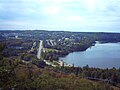
Elliot Lake (redirect from History of Elliot Lake)
Lake is a city in Algoma District, Ontario, Canada. It is north of Lake Huron, midway between the cities of Sudbury and Sault Ste. Marie in the Northern...
36 KB (2,844 words) - 19:27, 4 June 2024

Northern Ontario (redirect from Sports in Northern Ontario)
districts have provincially maintained secondary highways instead of county roads. Statistically, the districts in Northern Ontario (which appear in red...
62 KB (6,520 words) - 21:57, 12 June 2024
Superior. Near White River, the highway enters Algoma District and turns southward. It meets the western terminus of Highway 101 near Wawa, which provides...
89 KB (6,792 words) - 16:28, 20 June 2024

Ontario (redirect from Transport in Ontario)
Northern Ontario with the establishment of Algoma District and Nipissing District in 1858. An economic boom in the 1850s coincided with railway expansion...
163 KB (13,511 words) - 20:12, 29 June 2024