
Narmada district is an administrative district in the state of Gujarat in India. The district headquarters are located at Rajpipla. The district is bounded...
10 KB (548 words) - 08:40, 12 April 2024
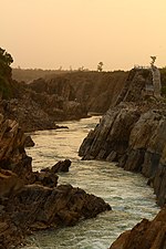
The Narmada River, previously also known as Narbada or anglicised as Nerbudda, is the 5th longest river in India and overall the longest west-flowing...
47 KB (5,422 words) - 21:39, 28 July 2024

Sardar Sarovar Dam (redirect from Narmada dam)
Sarovar Dam is a concrete gravity dam built on the Narmada River near the town of Kevadiya, in Narmada District, in the Indian state of Gujarat. The dam was...
32 KB (2,809 words) - 04:19, 13 April 2024
Look up Narmada in Wiktionary, the free dictionary. The Narmada River is in central India. Narmada or Nerbudda may also refer to: Narmada district of Gujarat...
529 bytes (110 words) - 04:14, 10 July 2024

List of talukas of Gujarat (section Narmada district)
"Village & Panchayats | District Narmada, Government of Gujarat | India". Retrieved 2023-03-24. "Village & Panchayats | District Navsari, Government of...
38 KB (607 words) - 22:00, 25 June 2024

Manvendra Singh Gohil (category People from Narmada district)
of Rajpipla Born (1965-09-23) 23 September 1965 (age 58) Ajmer, Ajmer district, Rajasthan, India Spouse Princess Chandrika Kumari of Jhabua (m. 1991;...
18 KB (1,733 words) - 13:38, 10 July 2024
Kevadia (redirect from Kevadiya, Narmada, Gujarat)
Kevadia (now known as Ekta Nagar) is a census town in Narmada district in the Indian state of Gujarat. The town is best known as the location of the Statue...
4 KB (217 words) - 04:25, 19 July 2024
portion of Hoshangabad District was split off to become Harda District. The district lies in the Narmada River valley, and the Narmada forms the northern...
13 KB (879 words) - 15:40, 2 June 2024
The Narmada Human, originally the Narmada Man, is a species of extinct human that lived in central India during the Middle and Late Pleistocene. From...
26 KB (2,969 words) - 06:59, 28 July 2024
Dediapada (category Cities and towns in Narmada district)
Dediyapada is a Tehsil and town in Narmada District with a sizable population of Tribal communities in which Vasava and Tadvi form the majority. This taluka...
3 KB (193 words) - 04:45, 17 March 2024

The Narmada Canal is a contour canal in Western India that brings water from the Sardar Sarovar Dam to the state of Gujarat and then into Rajasthan state...
9 KB (778 words) - 23:16, 3 February 2023

Statue of Unity (category Narmada district)
political integration of India. The statue is located in Gujarat on the Narmada River in the Kevadiya colony, facing the Sardar Sarovar Dam 100 kilometres...
35 KB (3,036 words) - 05:32, 25 July 2024

Rajpipla (category Cities and towns in Narmada district)
Rajpipla is a town and a municipality in the Narmada district in the Indian state of Gujarat. It was the capital of the former Kingdom of Rajpipla. Bhil...
5 KB (279 words) - 14:48, 11 April 2024
Omkareshwar Barwaha Kukshi Alirajpur Narmada Expressway connects 13 districts in Madhya Pradesh.[citation needed] May 2020: Narmada expressway project to be revived...
4 KB (281 words) - 15:16, 16 July 2024
Vadia is a census town in Narmada district in the Indian state of Gujarat. As of 2001 India census, Vadia had a population of 4479. Males constitute 59%...
3 KB (81 words) - 03:11, 17 September 2018
Narmada Nagar (pronunciation) is a township in Punasa Tehsil in East Nimar district of Madhya Pradesh, India. It belongs to Indore division. It is located...
5 KB (240 words) - 05:03, 3 May 2024
mother idol is that the idol of Panduri mother is in Nandurbar district and in Narmada district of Gujarat, the tribal women live in traditional costumes....
8 KB (1,432 words) - 20:15, 28 June 2024
Rajpipla State (category Narmada district)
517 sq mi) Population • 1941 2,49,032 History • Established 1340 • Merger with the Union of India 1948 Today part of Narmada district, Gujarat, India...
3 KB (252 words) - 16:04, 25 July 2024

after Indore. Jabalpur district is located in the Mahakoshal region of Madhya Pradesh, on the divide between the watersheds of Narmada and the Son, but mostly...
15 KB (863 words) - 18:23, 28 March 2024

The Narmada Valley dry deciduous forests are a tropical dry forest ecoregion of central India. The ecoregion lies mostly in Madhya Pradesh state, but...
9 KB (928 words) - 05:22, 16 April 2024
Tilakwada (category Villages in Narmada district)
Narmada district in the Indian state of Gujarat. It is the administrative headquarters of the Tilakwada Taluka. Before formation of Narmada District in...
3 KB (159 words) - 22:03, 28 January 2023
District. It is part of Shahdol Division. Anuppur district is mostly hilly and forested. The Narmada River originates from the hill of Amarkantak in the...
11 KB (781 words) - 01:37, 10 March 2024

Indo-Gangetic plain of northern India and the Deccan Plateau of the south. The Narmada River originates from north-eastern end of Satpura in Amarkantak, and runs...
20 KB (2,667 words) - 01:19, 5 August 2024

South Gujarat (section Cities and districts)
The districts in the region are Surat district, Bharuch district, Navsari district, Dang district, Valsad district, Narmada district and Tapi district. Bhulabhai...
7 KB (551 words) - 14:15, 18 May 2023

Narmada Valley Development Authority (NVDA) concerns Narmada River, the river of Madhya Pradesh. With 87% of its catchment area lying in Madhya Pradesh...
9 KB (789 words) - 10:19, 4 August 2024

Amarkantak (redirect from Narmada Kund)
Satpura Ranges, with the Maikal Hills being the fulcrum. This is where the Narmada River, the Son River and Johilla River (tributary of Son) originate. 15th-century...
11 KB (908 words) - 03:11, 19 June 2024

Hoshangabad (category Cities and towns in Hoshangabad district)
headquarters of both Hoshangabad district and Narmadapuram division. It is located in central India, on the south bank of the Narmada River. Hoshangabad is 76...
17 KB (1,415 words) - 12:48, 23 July 2024

place and the Ashram of Brighu Rishi is located on the banks of Narmada. The Narmada River outlets into the Gulf of Khambat through its lands and that...
11 KB (887 words) - 10:27, 16 May 2024

Omkareshwar Temple (category Tourist attractions in Khandwa district)
is on an island called Mandhata, near Khandwa city in the Narmada River at Khandwa district in Madhya Pradesh, India; the shape of the island is said...
12 KB (1,184 words) - 01:48, 30 July 2024
Ekta Nagar railway station (category Railway stations in Narmada district)
code: KDCY) is located in Kevadiya, Narmada district, Gujarat, India. It consists of 3 platforms. Facing the Narmada river, it is 7 kilometers away from...
6 KB (411 words) - 04:14, 30 July 2024