
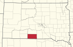
Rosebud County is a county in the state of Montana. It was established February 11, 1901, and has Montana vehicle license plate prefix 29. As of the 2020...
15 KB (763 words) - 00:30, 26 April 2024
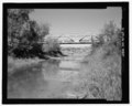
Rosebud is an unincorporated community, census-designated place and river town in Rosebud County, Montana, United States. It is located approximately...
6 KB (225 words) - 20:10, 22 September 2023

Colstrip is a city in Rosebud County, Montana, United States. The population was 2,096 at the 2020 census. Established in 1924 and incorporated as a city...
29 KB (2,543 words) - 09:57, 31 December 2023
Arkansas Rosebud, Alabama Rosebud, Georgia Rosebud, Warrick County, Indiana Rosebud, Washington County, Indiana Rosebud, Missouri Rosebud, Montana Rosebud, North...
3 KB (446 words) - 19:32, 24 February 2024

Birney is a census-designated place (CDP) in Rosebud County, Montana, United States. The population was 108 at the 2000 census. The post office was established...
8 KB (712 words) - 19:34, 5 July 2024
Rosebud Creek is a generally north flowing stream in Rosebud and Big Horn counties of Montana. It is a tributary to the Yellowstone River. The source...
3 KB (155 words) - 08:01, 16 October 2022

Ashland is a census-designated place (CDP) in Rosebud County, Montana, United States. The population was 464 at the 2000 census. Ashland is immediately...
9 KB (856 words) - 17:49, 22 September 2023

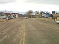
Forsyth is a city in and the county seat of Rosebud County, Montana, United States. The population was 1,647 at the 2020 census. Forsyth was established...
19 KB (1,431 words) - 05:52, 9 September 2023
(secondary coordinates) There are at least 32 named mountains in Rosebud County, Montana. Badger Peak, 45°38′33″N 106°32′52″W / 45.64250°N 106.54778°W...
6 KB (1,422 words) - 10:34, 31 August 2022

Treasure County, the next county is Rosebud County, about 15 miles (24 km) east. There are two intersections of US Highway 12 (US 12) and Montana Highway...
10 KB (298 words) - 00:11, 24 October 2023
(Meaveʼhoʼeno in Cheyenne) is a census-designated place (CDP) in Rosebud County, Montana, United States. The community is named after Miniconjou Lakota...
9 KB (696 words) - 20:09, 22 September 2023

Euphorbia marginata (category Flora of Montana)
naturalized throughout much of China. The type specimen was collected in Rosebud County, Montana from the area of the Yellowstone River by William Clark during...
4 KB (328 words) - 17:48, 27 July 2024
Hathaway is an unincorporated community in Rosebud County, Montana, United States. Hathaway is located at Exit 117 on Interstate 94, roughly 20 miles...
3 KB (141 words) - 02:07, 16 July 2024
(Arch Apex Gas Field), el. 4,039 feet (1,231 m) Bascom Oil Field, Rosebud County, Montana, 46°39′08″N 107°47′25″W / 46.65222°N 107.79028°W / 46.65222;...
12 KB (2,560 words) - 02:59, 13 February 2023

Ingomar is an unincorporated community in northwestern Rosebud County, Montana, United States, along the route of U.S. Route 12. The town was established...
6 KB (225 words) - 21:34, 10 June 2024

Roosevelt Rosebud United States presidential elections in Montana Presidency of George H. W. Bush The Political Graveyard; Blaine County, Montana Counting...
32 KB (397 words) - 22:37, 14 June 2024

Vananda is a former unincorporated village in northwestern Rosebud County, Montana, United States, along the route of U.S. Highway 12. The town was established...
3 KB (278 words) - 16:14, 29 July 2023
is located in present-day Rosebud County, Montana near Lame Deer. List of military installations in Montana "Southern Montana". Retrieved 4 August 2016...
2 KB (155 words) - 13:48, 20 April 2024
River), as well as part of northern Nebraska and eastern Montana. Since its founding, the Rosebud reservation has been reduced considerably in size, as has...
29 KB (3,055 words) - 14:47, 28 January 2024
coordinates) There are at least 69 named lakes and reservoirs in Rosebud County, Montana. Absolen Reservoir, 46°32′10″N 106°45′33″W / 46.53611°N 106.75917°W...
13 KB (3,138 words) - 22:32, 29 August 2024

Northern Cheyenne Indian Reservation (redirect from Northern Cheyenne Tribe of the Northern Cheyenne Indian Reservation, Montana)
in 1891 south of Kirby, Montana near the headwaters of the Rosebud Creek. They are now centered in and around Busby, Montana (Vóhpoométanéno) on the Northern...
20 KB (2,096 words) - 09:44, 29 May 2024
927 feet (1,197 m) Camp Loder, Garfield County, Montana, location unknown Camp Merritt, Rosebud County, Montana, 45°38′00″N 106°40′00″W / 45.63333°N...
18 KB (3,304 words) - 16:04, 27 March 2023

Deer Medicine Rocks (category Landforms of Rosebud County, Montana)
sandstone formation located on the west bank of Rosebud Creek in the vicinity of Lame Deer, Montana, United States. The formation is significant for...
4 KB (379 words) - 04:52, 6 August 2023
The Rosebud County Courthouse, located on Main St. between 12th and 13th Avenues in Forsyth in Rosebud County, Montana, was built in 1913. It was listed...
2 KB (120 words) - 04:49, 9 August 2023

Musselshell County – north Rosebud County – northeast Treasure County – east Big Horn County – southeast Carbon County – southwest Stillwater County – west...
18 KB (1,069 words) - 03:51, 10 August 2024
Marie Sanchez (category People from Rosebud County, Montana)
language. She was a Chief Judge of the Northern Cheyenne Tribe in Montana and a teacher at Montana State University and at Chief Dull Knife College. She was also...
7 KB (623 words) - 05:59, 30 April 2024

Glacier, and Roosevelt) or have some of Montana's most populous cities and towns, such as Missoula County (containing its namesake city, the second...
35 KB (504 words) - 02:02, 5 August 2024

(US 12) is an east–west United States Numbered Highway in the state of Montana. It extends approximately 597.576 miles (961.705 km) from the Idaho state...
17 KB (679 words) - 17:50, 19 August 2024
Sumatra is an unincorporated community in far northwestern Rosebud County, Montana, United States. It consists of a church and a post office, with respective...
3 KB (106 words) - 06:27, 29 July 2023

Musselshell River (category Rivers of Rosebud County, Montana)
Springs, Montana, just east of Martinsdale, north of Martinsdale Reservoir, and just west of Meagher County's border with Wheatland County. The North...
15 KB (1,283 words) - 19:40, 29 August 2024