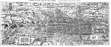
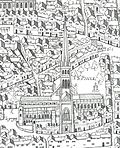
The "Woodcut" map of London, formally titled Civitas Londinum, and often referred to as the "Agas" map of London, is one of the earliest true maps (as...
9 KB (1,059 words) - 07:41, 23 January 2024

City of London Corporation Interactive maps (Electoral services: Ward boundaries) "Gardens of the City of London". Gardens of the City of London. Archived...
133 KB (12,071 words) - 01:32, 20 October 2024
medieval times, and is one of the streets shown on a map known as the "Woodcut map of London" or the "Agas" map, which survives in a 17th-century version. Its...
3 KB (324 words) - 10:31, 26 March 2024

aim of attacking and subduing the bull by biting and holding onto its nose or neck, which often resulted in the death of the bull. Crowds in London during...
14 KB (1,686 words) - 09:50, 17 July 2024
is shown in a series of detailed maps, particularly John Rocque's 1741–45 map (see below) and his 1746 Map of London. New districts such as Mayfair were...
86 KB (10,592 words) - 01:20, 6 September 2024

The Great Plague of London, lasting from 1665 to 1666, was the most recent major epidemic of the bubonic plague to occur in England. It happened within...
46 KB (6,369 words) - 20:43, 10 September 2024

the "Copperplate" map of London, dating to the 1550s, and on the derivative "Woodcut" map of the 1560s. It was described by the London historian John Stow...
40 KB (5,024 words) - 14:52, 27 September 2024
The "Copperplate" map of London is an early large-scale printed map of the City of London and its immediate environs, surveyed between 1553 and 1559,...
12 KB (1,285 words) - 07:30, 23 January 2024

Brick Lane (category Streets in the London Borough of Tower Hamlets)
local brick earth deposits. The street featured in the 16th-century Woodcut map of London as a partially developed crossroad leading north from the city's...
22 KB (2,454 words) - 21:21, 21 October 2024

Spitalfields (redirect from St. Mary Spital, London)
in the form Spittellond in 1399; as The spitel Fyeld on the "Woodcut" map of London of c.1561; and as Spyttlefeildes, also in 1561. The land belonged...
44 KB (4,874 words) - 22:34, 28 August 2024

Shad Thames (category Districts of London on the River Thames)
corner of the SE1 postcode district. The "Woodcut" map of London of c. 1561 calls the general area "Horssey Down". The 1872 Ordnance Survey 1:2500 map calls...
14 KB (1,743 words) - 12:18, 1 July 2024

Gray's Inn (redirect from The Honourable Society of Gray's Inn)
chapel, although an additional wing had been added by the date of the "Woodcut" map of London, drawn probably in the early 1560s. Expansion continued over...
63 KB (8,017 words) - 17:01, 22 September 2024
In 1563, London experienced its worst episode of plague during the sixteenth century. At least 20,136 people in London and surrounding parishes were recorded...
11 KB (1,156 words) - 17:33, 7 April 2024

Royal Mews (category Mews streets in London)
function. On old maps, such as the "Woodcut" map of London of the early 1560s, the Mews can be seen extending back towards the site of today's Leicester...
23 KB (2,490 words) - 00:26, 9 August 2024

woodcuts, an increasingly common process from 1500 onwards was the creation of prints from huge woodcuts and woodblocks. Jacopo de' Barbari's map of Venice...
8 KB (936 words) - 22:43, 14 June 2024

Peter Martyr map is a Spanish woodcut map composed in 1511 or 1514 and included in most or some copies of the 1511 edition of Decades of the New World...
31 KB (2,419 words) - 19:33, 24 September 2024
Fairmount, Baltimore City Civitas Londinum, the formal title of the 16th-century Woodcut map of London Sancta Civitas, a 20th-century oratorio by Ralph Vaughan...
1 KB (213 words) - 15:43, 18 September 2024

discoveries of the last years of the fifteenth and the first years of the sixteenth centuries. It consists of twelve sections printed from woodcuts measuring...
51 KB (7,080 words) - 02:22, 6 July 2024

Dürer's Rhinoceros (category Woodcuts)
Dürer's Rhinoceros is the name commonly given to a woodcut executed by German artist Albrecht Dürer in 1515. Dürer never saw the actual rhinoceros, which...
27 KB (3,216 words) - 14:14, 15 August 2024

of Antwerp promoted its present name in 1613. The earliest surviving maps on the projection appear as crude woodcut drawings of terrestrial globes of...
7 KB (858 words) - 17:27, 10 January 2023
Humphrey Mackworth (Parliamentarian) (category Members of the Privy Council of England)
secured control of his estates. She then married Adam Ottley of London, son of Richard Ottley of Pitchford Hall, Shropshire, by whom she had another son,...
102 KB (12,084 words) - 16:54, 23 February 2024

Star chart (redirect from Map of the night sky)
printed star chart, a 1515 set of woodcut portraits produced by Albrecht Dürer in Nuremberg, Germany. During the European Age of Discovery, expeditions to...
16 KB (1,898 words) - 21:36, 24 February 2024

Ralph Agas (section Maps)
hoping to undertake a survey of London, but had not done so. On the dubious evidence of this statement, a link with the Woodcut map was first made by the late...
16 KB (2,200 words) - 04:33, 23 April 2024

Cartography (redirect from Map making)
the Renaissance: woodcut and copper-plate intaglio, referring to the medium used to transfer the image onto paper. In woodcut, the map image is created...
61 KB (7,325 words) - 23:35, 18 October 2024

Fantasy cartography (redirect from Fictional map)
Fantasy cartography, fictional map-making, or geofiction is a type of map design that visually presents an imaginary world or concept, or represents a...
30 KB (2,861 words) - 07:29, 8 September 2024

Island.: 146–147 A Latin woodcut of the "first European map" published by Johann Reger [de] in Ulm in 1486 and thought to be one of the earliest surviving...
22 KB (1,902 words) - 02:31, 23 October 2024

located in Central London, part of Farringdon Without, the most westerly ward of the City of London, England. Smithfield is home to a number of City institutions...
68 KB (7,143 words) - 06:48, 17 August 2024

printers of the United States. In a reprint of Hubbard's narratives in 1865, editor Samuel G. Drake described the map as "the curious Woodcut Map." Pfeiffer...
9 KB (1,027 words) - 04:30, 9 June 2024
Essex. Of those windmills known to have existed, nine remain and are preserved; as are the tide mills at Three Mills, West Ham. c.1563 "Woodcut" (or "Agas")...
46 KB (797 words) - 05:10, 21 August 2023

80 Coleman Street (category Grade II listed buildings in the City of London)
generation to generation. The "Woodcut" map of London of c.1561 shows the site of No.80 Coleman Street occupied by some part of two small houses immediately...
9 KB (1,404 words) - 02:51, 19 April 2022