
The Barnim Plateau is a plateau which is occupied by the northeastern parts of Berlin and the surrounding federal state of Brandenburg in Germany. The...
12 KB (1,433 words) - 15:41, 9 March 2024
name "Barnim" emerged in the 13th century and was applied to a large forest region east of the Havel and north of the Spree on the homonymous plateau, where...
6 KB (412 words) - 07:53, 20 August 2024
in north-western Poland Barnim Plateau Slavic names This disambiguation page lists articles associated with the title Barnim. If an internal link led...
1 KB (114 words) - 18:35, 1 December 2022

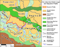
Urstromtal (an ice age glacial valley), between the low Barnim Plateau to the north and the Teltow plateau to the south, was formed by meltwater flowing from...
237 KB (19,469 words) - 12:53, 7 September 2024

oval-shaped lake, a relic of the last ice age, is located on the Barnim Plateau and part of the Barnim Nature Park. It covers an area of approximately 9,200 m2...
4 KB (343 words) - 13:40, 14 August 2024
12-15 kilometres northwest of Berlin and is adjacent to the larger Barnim Plateau. Joachim Jauch (1996). Spandau. Luisenstädtischer Bildungsverein. p...
662 bytes (51 words) - 09:25, 27 February 2022

and extended hospital premises. The settlement area is located on the Barnim Plateau stretching in the northeast of the Berlin city centre up to the Oder–Havel...
7 KB (803 words) - 20:20, 20 August 2024

Ahrensfelde (category Localities in Barnim)
Ahrensfelde is a municipality in the district of Barnim, in Brandenburg, Germany. It is situated on the Barnim Plateau at the city limits of Berlin, about 13 km...
5 KB (434 words) - 12:33, 9 May 2024

Brandenburg and Berlin, a right tributary of the Spree, originating from the Barnim plateau. It has a length of 29 km, of which 20,2 are within the area of Berlin...
3 KB (320 words) - 07:39, 29 May 2024

Urstromtal (ice age glacial valley), between the low Barnim Plateau to the north and the Teltow Plateau to the south, was formed by meltwater flowing from...
37 KB (2,740 words) - 16:15, 25 July 2024
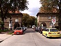
contemporary borough of Lichtenberg. Alt-Hohenschönhausen is situated on the Barnim Plateau in the northeast of Berlin. It borders on the localities of Neu-Hohenschönhausen...
12 KB (1,244 words) - 20:16, 20 August 2024

meter high Veteranenberg, an elevation on the southwestern edge of the Barnim plateau and is registered as a garden monument with the number 09010210 in the...
3 KB (428 words) - 00:25, 1 September 2022

Biesenthal (category Localities in Barnim)
Berlin (centre). The surrounding Biesenthal Basin is part of the Barnim Plateau and the Barnim Nature Park, characterised by numerous kames and glacial lakes...
5 KB (424 words) - 14:39, 27 June 2024

the northwestern rim of the Oderbruch basin and the steep rise of the Barnim Plateau. It is located 15 km (9.3 mi) east of Eberswalde, and 50 km (31 mi)...
7 KB (633 words) - 18:16, 11 June 2024

Wandlitz (category Localities in Barnim)
Wandlitz is a municipality in the district of Barnim, in Brandenburg, Germany. It is situated 25 km north of Berlin, and 15 km east of Oranienburg. The...
8 KB (761 words) - 13:41, 14 August 2024

Teltow (region) (redirect from Teltow plateau)
the southwest and the Berlin Urstromtal forms the boundary with the Barnim Plateau in the northeast. It is, however, disputed whether the Müggelberge hills...
30 KB (1,131 words) - 20:46, 20 August 2024

marsh forest and moor area. The deep cut of the Nonnenfließ into the Barnim plateau creates an almost low-mountain-like landscape. The river meanders strongly...
5 KB (545 words) - 20:24, 1 May 2024

forming here the narrowest point between the northerly Barnim Plateau and southern Teltow Plateau. The oldest surviving record mentioning the Kreuzberg...
46 KB (5,521 words) - 18:23, 31 October 2023

period, when John I and Otto III settled the sparsely populated plateaus of Teltow and Barnim with local Slavs and German immigrants. According to Adriaan...
35 KB (4,282 words) - 05:57, 8 April 2024
period, when John I and Otto III settled the sparsely populated plateaus of Teltow and Barnim with local Slavs and German immigrants. According to Adriaan...
37 KB (4,523 words) - 03:19, 13 July 2024

Hohenfinow (category Localities in Barnim)
Eberswalde. It is part of a rural area on the northeastern rim of the Barnim Plateau, south of the Finow River and the Finow Canal. The glacial valley in...
5 KB (375 words) - 14:45, 27 June 2024
southeast and the Barnim to the northeast have the same name as their geological formation, the cultural landscape on the Nauen Plateau bears the historical...
7 KB (888 words) - 10:54, 2 October 2019
in the southwest (in the direction of Halle and Wittenberg) to the Barnim Plateau in the northeast (in the direction of Oderberg and Stettin), crossing...
6 KB (833 words) - 16:20, 3 July 2022

Havel Valley. Between these valleys rise a series of hills and plateaus, such as the Barnim, the Teltow, the Semmelberg near Bad Freienwalde (157 m, 515 ft)...
35 KB (3,951 words) - 18:11, 20 August 2024

political domination of the area. After Ascanian victory in 1245 the Barnim and Teltow plateaus remained as part of the Margraviate of Brandenburg and the subsequent...
4 KB (392 words) - 00:15, 11 March 2024

Teltow plateau from the Nauener Platte to the northwest with Gatow and parts of Wilhelmstadt. The Spreeniederung separates the plateau from the Barnim. While...
60 KB (6,612 words) - 03:05, 4 September 2024

moraines, heath, forest, and numerous ponds. Barnim Brandenburg Berlin 1999 749 The park includes the Barnim heath habitats dating back to the ice age...
48 KB (359 words) - 19:51, 7 September 2023

Buckow Groove (German: Buckower Rinne), separates the northwestern plateau of the Barnim (de) from the southeastern upland area of the Land Lebus. The high...
7 KB (676 words) - 21:21, 27 March 2022

to settle to the north and south of the glacial valley on the Barnim and Teltow plateaus to be able to construct deep basements for manufacturing and storage...
169 KB (17,547 words) - 08:41, 3 September 2024
Pomerelia (d. 1233), Regent Duchess of Pomerania-Wolgast, 1220–33, for her son Barnim I of Pomerania-Wolgast (1219–1264) Munia Mayor of Castile (Munia Elvira))...
142 KB (11,276 words) - 19:31, 25 June 2024