
height of 4,166 m (13,668 ft) about 12 km (7.5 mi) north of Kaza town. In 2022, the Himachal Pradesh government constructed an indoor gym at a cost of Rs. 10...
13 KB (1,283 words) - 10:53, 23 June 2024

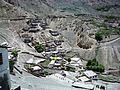
on the banks of the Spiti River in Himachal Pradesh, India. The town lies on the road between Rekong Peo and Kaza (alternative spelling: Kaja), the sub-divisional...
5 KB (383 words) - 08:31, 11 October 2023

Lahaul and Spiti district (category 1960 establishments in Himachal Pradesh)
The Lahaul and Spiti district in the Indian state of Himachal Pradesh consists of the two formerly separate districts of Lahaul (Tibetan: གར་ཞ་, Wylie:...
29 KB (2,655 words) - 05:27, 17 June 2024
Dhankar Village (category Himachal Pradesh geography stubs)
in Himachal Pradesh, India. It is at an altitude of 3,894 metres (12,774 feet) above sea level, between the towns of Tabo and Kaza, Himachal Pradesh. Above...
8 KB (571 words) - 15:27, 29 February 2024

Buddhism in the Himachal Pradesh state of India of has been a long-recorded practice. The spread of Buddhism in the region has occurred intermediately...
51 KB (6,125 words) - 20:51, 19 June 2024

Losar Khas (category Gram panchayats in Himachal Pradesh)
the Spiti River. Located on NH-505, 58 kilometres (36 mi) from Kaza, Himachal Pradesh and 78 kilometres (48 mi) from Gramphoo. It covers an area of 360...
8 KB (631 words) - 12:42, 27 September 2023
up kaza in Wiktionary, the free dictionary. A Kaza or qadaa is a subnational entity in the Arab world. Kaza or KAZA may also refer to: Kaza, Himachal Pradesh...
957 bytes (164 words) - 14:28, 7 July 2024

Himachal Road Transport Corporation, also referred to as HRTC, is the state-owned road transport corporation of the state of Himachal Pradesh, India....
12 KB (1,096 words) - 16:19, 1 July 2024

Hikkim (redirect from Hikkim, Himachal Pradesh)
in the northern Indian state of Himachal Pradesh at an elevation of 4,400 m (14,400 ft). It is 46 km (29 mi) from Kaza, the nearest town connected by road...
9 KB (551 words) - 19:52, 14 December 2023

Spiti (category Valleys of Himachal Pradesh)
into a sub-division with its headquarter at Kaza. Lahaul and Spiti district was merged with Himachal Pradesh on 1 November 1966 on enactment of the Punjab...
58 KB (6,087 words) - 10:02, 4 July 2024

Kunzum Pass (category Mountain passes of Himachal Pradesh)
in Lahaul to Kaza the subdivisional headquarters of Spiti. Kunzum Pass on NH505 is 122 km (76 mi) from Manali, and 79 km (49 mi) from Kaza. NH505 over...
4 KB (389 words) - 18:57, 28 April 2023

Kibber (category Buddhist monasteries in Himachal Pradesh)
high in the Spiti Valley in the Himalayas at 4,270 m (14,010 ft) in Himachal Pradesh in northern India. It contains a monastery and is a base for visiting...
23 KB (2,380 words) - 05:44, 14 December 2023
The world's highest retail outlet (at an altitude of 3,740 mtr. above mean sea level) under IOCL, in Kaza, Himachal Pradesh...
31 KB (2,332 words) - 09:57, 6 July 2024

from Shimla on NH 5 and NH 505 to Kaza in Spiti via Nako. From Nako, taxis are available to Leo. Nako, Himachal Pradesh Spiti Valley Wikimedia Commons has...
9 KB (822 words) - 01:35, 27 September 2023
Shimla, Himachal Pradesh Ice Rink, Gulmarg, Jammu and Kashmir Ice Rink, Leh, Ladakh Ice Rink, Kargil, Ladakh Ice Rink, Kaza, Himachal Pradesh "List of...
5 KB (295 words) - 17:57, 8 August 2023

Gue is a village in the Lahul & Spiti district of the state of Himachal Pradesh in India. The village is about 40 km from the Tabo Monastery, at latitude...
1 KB (134 words) - 14:25, 18 June 2024

Sissu (category Himachal Pradesh geography stubs)
Sissu (also known as Khwaling) is a small town in the Lahaul valley of Himachal Pradesh in India. It is around 40 km from Manali and located on the right bank...
6 KB (486 words) - 11:29, 23 May 2023
Department of Transport for Gujarat: Transport Department Gujarat for Himachal Pradesh: Transport Department for Karnataka: Government of Karnataka – Transport...
129 KB (442 words) - 02:13, 14 July 2024

population 202): 81–82 is a village in Lahaul, in the Indian state of Himachal Pradesh. Jispa is located 22 km (14 mi) north of Keylong and 7 km (4.3 mi)...
5 KB (269 words) - 22:00, 30 March 2024

Chandra Taal (category Lakes of Himachal Pradesh)
lake in the upper Chandra valley of the Lahul and Spiti district of Himachal Pradesh, India. Chandra Taal is near the source of the Chandra River. Despite...
7 KB (600 words) - 19:12, 19 May 2024
and (Hindi: कौरिक) is a village in the Lahul and Spiti district, in Himachal Pradesh, India. It is in the valley of the Parang or Pare Chu river before...
5 KB (305 words) - 01:01, 30 October 2023

Rohtang Pass (category Mountain passes of Himachal Pradesh)
Manali in the Indian state of Himachal Pradesh. It connects the Kullu Valley with the Lahaul and Spiti Valleys of Himachal Pradesh, India. The pass provides...
9 KB (951 words) - 09:42, 2 July 2024

and Muth) is a small village in the cold desert region of Spiti in Himachal Pradesh, India. Located at an altitude of 3,810 m (12,500 ft) on the left bank...
24 KB (2,311 words) - 20:54, 21 February 2024

National Highway 505 (India) (category National Highways in Himachal Pradesh)
state of Himachal Pradesh in India. NH 505 is a high elevation road, covering the Kinnaur and Lahaul and Spiti districts of Himachal Pradesh, mainly running...
13 KB (1,230 words) - 01:39, 4 June 2024

India–China Border Roads (category Proposed infrastructure in Himachal Pradesh)
ICBRs are present in Jammu and Kashmir, Ladakh, Himachal Pradesh, Uttarakhand, Sikkim and Arunachal Pradesh. In May 2022, Indian govt sources announced establishment...
87 KB (5,294 words) - 07:10, 24 May 2024

administrative centre of the Lahaul and Spiti district in the Indian state of Himachal Pradesh, 71 kilometres (44 mi) north of Manali via Atal Tunnel and 120 km (75 mi)...
10 KB (737 words) - 09:02, 12 March 2024

Key Monastery (category Buddhist monasteries in Himachal Pradesh)
above sea level, close to the Spiti River, in the Spiti Valley of Himachal Pradesh, Lahaul and Spiti district, India. It is the largest monastery of the...
8 KB (883 words) - 17:34, 5 July 2024

Takling La (category Mountain passes of Himachal Pradesh)
(Pass). Takling La is a mountain pass located in the Spiti district of Himachal Pradesh, India. It is a 5,575 metres (18,291 ft) high pass and is parallel...
3 KB (310 words) - 19:45, 1 July 2022

Tangyud Monastery (category Buddhist monasteries in Himachal Pradesh)
village of Komic, two km southeast of Hikkim in the Spiti Valley of Himachal Pradesh, India, is built like a fortified castle on the edge of a deep canyon...
5 KB (521 words) - 17:32, 6 October 2022

on opposite banks of a nullah in the cold desert region of Spiti in Himachal Pradesh, India. The villages, at an altitude of 3,650 m (11,980 ft), are located...
13 KB (1,166 words) - 20:10, 21 October 2023