
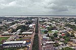
Tabatinga, originally Forte de São Francisco Xavier de Tabatinga, is a municipality in the Três Fronteiras area of Western Amazonas. It is in the Brazilian...
12 KB (1,173 words) - 16:06, 19 August 2024

Amazon River (redirect from Amazonas River)
Amazon River (UK: /ˈæməzən/, US: /ˈæməzɒn/; Spanish: Río Amazonas, Portuguese: Rio Amazonas) in South America is the largest river by discharge volume...
116 KB (10,136 words) - 04:41, 26 September 2024
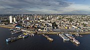
Manaus (redirect from Manaus, Amazonas)
Federal University of Amazonas—Universidade Federal do Amazonas; University of the State of Amazonas—Universidade do Estado do Amazonas; National Institute...
85 KB (8,138 words) - 09:15, 23 September 2024

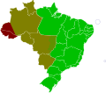
Amazonas (Brazilian Portuguese: [ɐmaˈzonɐs] ) is a state of Brazil, located in the North Region in the north-western corner of the country. It is the largest...
61 KB (6,476 words) - 12:35, 4 September 2024

southernmost city in the Republic of Colombia, capital of the department of Amazonas, Colombia's southernmost town (4.09° south 69.57° west) and one of the...
16 KB (1,289 words) - 02:58, 14 September 2024
and the southwestern portion of the state of Amazonas (west of a line connecting the cities of Tabatinga and Porto Acre). These areas cover only about...
14 KB (1,308 words) - 11:47, 1 August 2024

list of the municipalities in the state of Amazonas (AM), located in the North Region of Brazil. Amazonas is divided into 62 municipalities. † State...
23 KB (206 words) - 08:34, 20 September 2024
International Airport Tbilisi, Georgia TBT SBTT Tabatinga International Airport Tabatinga, Amazonas, Brazil TBU NFTF Fuaʻamotu International Airport...
57 KB (173 words) - 02:26, 24 June 2024

Humaitá is a municipality located in the Brazilian state of Amazonas. Its population was 56,144 (2020) and its area is 33,072 km2. The city is located...
5 KB (193 words) - 20:30, 19 August 2024

facilities in Benjamin Constant, and entry and exit formalities take place at Tabatinga on the opposite bank of the Amazon. There are no roads into Benjamin Constant...
7 KB (229 words) - 16:03, 19 August 2024

3rd in the Paraguay River basin. A 4th battalion is planned for Tabatinga, Amazonas, aswell a Riverine Landing Troop Command, headquartered in the Amazon...
114 KB (12,196 words) - 19:20, 26 September 2024

Alvarães is a municipality located in the Brazilian state of Amazonas. Its population was 16,220 (2020) and its area is 5,912 km². The municipality contains...
3 KB (76 words) - 03:12, 19 August 2024
The Amazonas State University (Portuguese: Universidade do Estado do Amazonas, UEA) is a Brazilian public university operated by the state of Amazonas, located...
10 KB (1,019 words) - 23:21, 22 July 2024
Rádio Nacional (section State of Amazonas)
1 MHz) Rádio Nacional do Alto Solimões (AM 670 kHz and FM 96.1 MHz - Tabatinga region) - Seven daily hours with news, music, local culture and service...
5 KB (477 words) - 04:49, 23 February 2024

The history of Amazonas is the result of treaties, religious missions and a few indigenous rebellions in the Amazon territory. Initially, under the Treaty...
34 KB (3,848 words) - 01:04, 29 August 2024

Silves or Ilha de Silves is an island municipality in the state of Amazonas, northern Brazil. It is located 10 km straight line north or about 40 km by...
3 KB (207 words) - 03:05, 19 August 2024
Itacoatiara is a municipality in the central eastern portion of state of Amazonas, inland northern Brazil. Its population was 102,701 (2020) and its area...
14 KB (847 words) - 02:30, 20 September 2024

pronunciation: [ʒuɾuˈa]) is a municipality located in the Brazilian state of Amazonas. Its population was 15,106 (2020) and its area is 19,400 km². The municipality...
3 KB (109 words) - 20:28, 19 August 2024

São Paulo de Olivença (redirect from São Paulo de Olivença, Amazonas)
is a community and a municipality near the western edge of the state of Amazonas near the tri-country border area in Brazil. The population is 40,073 (2020...
4 KB (152 words) - 16:05, 19 August 2024

Tabatinga International Airport (IATA: TBT, ICAO: SBTT) is the airport serving Tabatinga, Brazil. It is operated by Vinci SA. Previously operated by Infraero...
5 KB (294 words) - 10:23, 9 June 2024
This is a list of municipalities in Amazonas ordered by Human Development Index (HDI) according to data released by the United Nations Development Program...
19 KB (304 words) - 00:32, 11 April 2024
Feijoal is a village in the municipality Benjamin Constant, in the state of Amazonas, Brazil. It is situated on the right bank of the river Solimões, 35 km...
955 bytes (115 words) - 17:09, 24 May 2020

Panama City, George Town Brazil Acre Amazonas (13 western municipalities, approximately marked by a line between Tabatinga and Porto Acre) Colombia – Time...
11 KB (764 words) - 11:26, 24 September 2024

Iquitos (redirect from San León del Amazonas)
again to the Viceroyalty of Peru. The Portuguese advance was halted at Tabatinga. In the early 19th century, following independence, Peru, Ecuador, Colombia...
100 KB (11,663 words) - 05:34, 16 September 2024

Itapiranga is a municipality located in the state of Amazonas northern Brazil on the left bank of the Solimões River about 200 km east of Manaus. Its population...
3 KB (143 words) - 03:04, 19 August 2024
Taraíra River (category Rivers of Amazonas (Brazilian state))
Rio Traíra – Amazonas (in Portuguese)- National Gold Prospecting Program – PNPO, Map of gold deposits, Area AM-04 - Traíra River – Amazonas" (PDF). rigeo...
5 KB (465 words) - 16:23, 5 May 2023

Tefé (category Municipalities in Amazonas (Brazilian state))
Tefé, known in early accounts as Teffé, is a municipality in the state of Amazonas, northern Brazil. As early as 1620 the Portuguese Carmelites could already...
11 KB (673 words) - 03:29, 30 August 2024

Santo Antônio do Içá (redirect from Santo Antônio do Içá, Amazonas, Brazil)
Santo Antônio do Içá is a community and a municipality in the state of Amazonas near the Colombian border in Brazil. The population is 21,243 (2020 est...
4 KB (131 words) - 16:04, 19 August 2024

cases: 15 May 2020. "Amazonas confirma 1º caso de Covid-19 e autoridades garantem que rede de assistência está preparada - SUSAM" [Amazonas confirms 1st case...
18 KB (1,730 words) - 08:43, 6 November 2023

Brazil–Peru border (category Amazonas (Brazilian state) articles missing geocoordinate data)
that limits the territories of Brazil and Peru. The Brazilian states of Amazonas and Acre border the eastern Peruvian regions of Loreto, Ucayali and Madre...
4 KB (269 words) - 06:26, 24 November 2021