
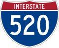
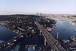
State Route 520 (SR 520) is a state highway and freeway in the Seattle metropolitan area, part of the U.S. state of Washington. It runs 13 miles (21 km)...
72 KB (6,685 words) - 19:55, 18 August 2024
carries Washington State Route 520 Evergreen Point Floating Bridge (1963) (opened 1963, closed 2016), the original Washington State Route 520 crossing...
582 bytes (108 words) - 01:47, 24 March 2021
internal designation State Route 415 (SR 415). The entire length of I-520 is part of the National Highway System, a system of routes determined to be the...
16 KB (1,515 words) - 05:51, 2 August 2024

Evergreen Point Floating Bridge (redirect from 520 floating bridge)
known as the 520 Bridge and officially the Governor Albert D. Rosellini Bridge, carries Washington State Route 520 across Lake Washington from Seattle...
46 KB (4,106 words) - 11:10, 20 May 2024

State Route 513 (SR 513) is a 3.35-mile-long (5.39 km) state highway in the U.S. state of Washington, located entirely within the city of Seattle in King...
16 KB (1,487 words) - 00:50, 15 August 2024

State Route 520 (SR 520), also known as the South Georgia Parkway, is a 261-mile-long (420 km) state highway in the southern part of the U.S. state of...
35 KB (2,772 words) - 00:49, 5 August 2024

State Route 20 (SR 20), also known as the North Cascades Highway, is a state highway that traverses the U.S. state of Washington. It is the state's longest...
49 KB (4,516 words) - 22:30, 4 August 2024
Highway 520 (India) R520 regional road Interstate 520 Florida State Road 520 Georgia State Route 520 Indiana State Road 520 Nevada State Route 520 (former)...
2 KB (130 words) - 23:11, 4 April 2024

eastern edge of Lake Washington, lying between the lake's Cozy Cove and Yarrow Bay and nearly all of it north of Washington State Route 520. It is bordered...
15 KB (1,162 words) - 17:29, 6 May 2024

system is defined through acts by the state legislature and is encoded in the Revised Code of Washington as State Routes (SR). It was created in 1964 to replace...
80 KB (208 words) - 18:40, 18 August 2024

East Montlake Park (category King County, Washington geography stubs)
Seattle, Washington, USA. The park is bounded on the north by the Montlake Cut, on the east by Union Bay, on the south by Washington State Route 520, and...
3 KB (273 words) - 05:49, 30 June 2024

Since the 1964 state highway renumbering, which established the current state route system, the Washington State Department of Transportation has decommissioned...
37 KB (3,406 words) - 03:19, 15 June 2024

Island is an island in Seattle, Washington, USA's Union Bay. Bisected by State Route 520, it is part of the Washington Park Arboretum. There is a walking...
1 KB (127 words) - 08:31, 26 April 2020

Interstate 5 (redirect from Interstate 5 (California–Washington))
covered by Freeway Park and the Washington State Convention Center. It then turns north to intersect Washington State Route 520 near Eastlake and crosses the...
44 KB (4,024 words) - 18:25, 11 August 2024

Seattle, Washington, US Aubrey Davis Park, Mercer Island, Washington, US Evergreen Point, Hunts Point, and Yarrow Point on Washington State Route 520, Bellevue...
7 KB (676 words) - 00:45, 5 August 2024

State Route 99 (SR 99), also known as the Pacific Highway, is a state highway in the Seattle metropolitan area, part of the U.S. state of Washington. It...
125 KB (12,500 words) - 23:25, 18 August 2024
Washington, officially the State of Washington, is the westernmost state in the Pacific Northwest region of the United States. It is often referred to...
246 KB (19,047 words) - 14:18, 17 August 2024

State Route 522 (SR 522) is a state highway in the U.S. state of Washington that serves the Seattle metropolitan area. Approximately 25 miles (40 km)...
60 KB (5,524 words) - 00:22, 17 August 2024
beyond. State Route 520 cuts through Foster Island and the Union Bay wetlands at the park's northern end, interchanging with Lake Washington Boulevard...
11 KB (1,222 words) - 16:57, 30 May 2023
Seattle, which lies across Lake Washington on State Route 520. With an annual bike race on city streets and the state's only velodrome, Redmond is also...
51 KB (4,302 words) - 02:50, 17 August 2024

State Route 202 (SR 202) is a state highway in the U.S. state of Washington, serving part of the Seattle metropolitan area. It runs southeasterly for...
22 KB (2,121 words) - 05:27, 15 June 2024

State Route 18 (SR 18) is a 28.41-mile-long (45.72 km) state highway in the U.S. state of Washington, serving southeastern King County. The highway travels...
31 KB (2,780 words) - 01:47, 5 August 2024

State Route 519 (SR 519) is a state highway in Seattle, Washington, United States. It connects Interstate 90 (I-90) to the Port of Seattle and Colman Dock...
14 KB (1,313 words) - 00:51, 15 August 2024

State Route 908, commonly known as SR 908 or Highway 908, was a state highway in the U.S. state of Washington. Prior to its decommissioning in 2010, it...
5 KB (486 words) - 01:22, 7 August 2024

State Route 213 (SR 213) is the shortest state highway in the U.S. state of Washington. The 0.35-mile-long (0.56 km) unsigned highway serves Malott, a...
12 KB (985 words) - 05:27, 15 June 2024
List of bridges in Seattle (category Lists of buildings and structures in Washington (state))
Floating bridges carry Interstate 90 and State Route 520 across Lake Washington to the Eastside suburbs. The SR 520 Albert D. Rosellini Evergreen Point Floating...
37 KB (1,815 words) - 01:05, 5 August 2024
Portage Bay in Seattle that were intended to be an interchange from Washington State Route 520 and the proposed R. H. Thomson Expressway. When plans for the...
47 KB (5,715 words) - 04:56, 18 August 2024

Montlake, Seattle (redirect from Montlake, Seattle, Washington)
and west sides, and the University of Washington campus lies across the Montlake Cut to the north. State Route 520 runs through the northern tip of Montlake...
14 KB (1,190 words) - 04:26, 11 August 2024
completed in 1972, and the first HOV lanes in Washington were installed on SR 520 that same year. A combined state department of transportation was proposed...
23 KB (1,970 words) - 01:19, 26 March 2024

East Lake Sammamish Trail (category Rail trails in Washington (state))
on 21 March 2006. A future bridge across Bear Creek and under Washington State Route 520 will connect the north end of the East Lake Sammamish Trail to...
3 KB (217 words) - 10:02, 12 November 2023