
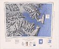
The Adare Peninsula (71°40′S 170°30′E / 71.667°S 170.500°E / -71.667; 170.500), is a high ice-covered peninsula, 40 nautical miles (74 km; 46 mi) long...
10 KB (1,546 words) - 06:01, 5 April 2024

Cape Adare Cape Adare is a prominent cape of black basalt forming the northern tip of the Adare Peninsula and the north-easternmost extremity of Victoria...
12 KB (1,269 words) - 21:50, 28 June 2024
Antarctica. It is an elongated basalt dome similar to Adare Peninsula and Hallett Peninsula and rises to 2,000 metres (6,600 ft). It is partly separated...
8 KB (1,254 words) - 06:44, 20 April 2024

Retrieved 2020-03-21. "Adare Peninsula". Global Volcanism Program. Smithsonian Institution. Retrieved 2018-01-20. "Adare Peninsula". Geographic Names Information...
21 KB (1,619 words) - 13:01, 4 April 2024
Adare is a village in County Limerick, Ireland. Adare may also refer to: Adare GAA, GAA club based in Adare Adare Manor, manor house in Adare Adare Productions...
675 bytes (113 words) - 01:51, 31 May 2017

bay from further north on the Adare Peninsula, which defines the east coast of the bay, extending north to Cape Adare. 71°26′S 169°12′E / 71.433°S...
17 KB (2,857 words) - 21:59, 9 March 2024

their east they are bounded by the Southern Ocean, Robertson Bay, the Adare Peninsula and the Ross Sea. The Dennistoun Glacier which flows past the northeastern...
11 KB (1,402 words) - 23:47, 30 March 2024
the southern point on the Adare Peninsula. To the west of Cape Roget the Moubray Glacier flows south to the bay from the Adare Saddle. The DeAngelo Glacier...
12 KB (2,081 words) - 23:53, 30 March 2024
tributaries of the Moubray Glacier, which flows down the west side of the Adare Peninsula. The Murray Glacier originates to the north of the ridge. It is east...
5 KB (721 words) - 22:30, 25 July 2024
Adare Seamounts, also known as Adare Mountains, are the seamounts in Balleny Basin named in association with Adare Peninsula and Cape Adare. Name approved...
1 KB (53 words) - 02:02, 27 June 2021

Institution of Oceanography. It was named in association with the Adare Peninsula and Cape Adare. The name was approved by the Advisory Committee on Undersea...
570 bytes (81 words) - 04:55, 14 November 2021

Southern Cross Expedition (section Cape Adare)
sailed in the Southern Cross, and spent the southern winter of 1899 at Cape Adare, the northwest extremity of the Ross Sea coastline. Here they carried out...
37 KB (4,073 words) - 21:18, 28 June 2024

Antarctandes (redirect from Antarctic Peninsula cordillera)
coast of the Ross Sea to Cape Adare. The major transcontinental Transantarctic Mountains System shares the Cape Adare to Queen Maud ranges with the Antarctandes...
4 KB (363 words) - 23:14, 26 August 2024
62083°S 170.55139°E / -71.62083; 170.55139) is the highest peak on Adare Peninsula, Victoria Land, rising to 2,083 metres (6,834 ft). It stands sharply...
922 bytes (140 words) - 19:20, 9 March 2024
southernmost of the Possession Islands, lying east of the south end of the Adare Peninsula. Named by a Norwegian expedition of 1894-95, led by Bull and Kristensen...
7 KB (999 words) - 18:30, 23 January 2024

Victor Harbor, South Australia (redirect from Adare House)
Adare House (as of 2024[update] known Adare Conference Centre) was listed on the South Australian Heritage Register in 1999. The land on which Adare House...
44 KB (4,407 words) - 10:51, 22 July 2024

000 m above the Ross Sea and forming much of the eastern side of the Adare Peninsula, along the Borchgrevink Coast of northern Victoria Land, Antarctica...
2 KB (243 words) - 17:32, 12 August 2024

Hut Point Peninsula (77°47′S 166°51′E / 77.783°S 166.850°E / -77.783; 166.850) is a long, narrow peninsula from 2 to 3 nautical miles (3.7 to 5.6 km;...
16 KB (2,687 words) - 05:54, 8 July 2024

is a steep rock cape at the southern end of the east coast of the Adare Peninsula, marking the northern side of the entrance to Moubray Bay, in northern...
1 KB (146 words) - 15:44, 7 July 2023

Cape Adare to the Queen Maud Mountains, but extending thence through the Whitmore Mountains and Ellsworth Mountains up the Antarctic Peninsula. The 100–300 km...
13 KB (1,326 words) - 14:37, 13 June 2024
on the northern tip of the Hallett Peninsula on the Ross Sea coast of Victoria Land, East Antarctica. Cape Adare lies 100 km (62 mi) to the north. In...
6 KB (481 words) - 17:04, 29 February 2024
subaerial environment instead. Adare Peninsula Hanson Peak Hargreaves Peak Coulman Island Hawkes Heights Daniell Peninsula Mount Brewster Mount Lubbock...
7 KB (555 words) - 20:23, 9 March 2024

the north end of the peninsula. The peninsula is an elongated shield volcano complex similar to the Adare and Daniell peninsulas. It forms part of the...
11 KB (1,748 words) - 06:33, 20 April 2024
Topo South survey of mountains west of the Ross Sea from Cape Roget, Adare Peninsula, to Otway Massif at the head of Beardmore Glacier, a traverse totalling...
6 KB (641 words) - 18:19, 13 January 2024

Paradise Harbour (redirect from Coughtrey_Peninsula)
Paradise Harbour is off the Danco Coast on the west side of the Antarctic Peninsula. The Brown (Argentina) and Videla (Chile) stations are on tis eastern...
12 KB (1,769 words) - 14:52, 19 July 2024
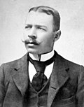
Norwegian/British explorer, led the British Antarctic Expedition to Cape Adare, where he established the first Antarctic base on Ridley Beach. This expedition...
78 KB (2,409 words) - 22:36, 23 August 2024

Bailey Peninsula is a rocky peninsula, about 2.6 km (2 mi) long and 1.5 km (1 mi) wide, on the Budd Coast of Wilkes Land in Antarctica. It is the site...
2 KB (188 words) - 23:13, 26 August 2024

1980s on a beach on Livingston Island (South Shetlands) off the Antarctic Peninsula. Emilio Marcos Palma (born January 7, 1978) is an Argentine citizen who...
14 KB (1,255 words) - 06:38, 3 July 2024
Clark Peninsula is a rocky peninsula, about 3 km (2 mi) long and wide, lying 5 km (3 mi) north-east of Australia's Casey Station at the north side of Newcomb...
8 KB (935 words) - 14:17, 1 February 2024
John Davis, on the Antarctic Peninsula on 7 February 1821, or by other whaling expeditions. While ashore at Cape Adare, Borchgrevink collected further...
48 KB (5,128 words) - 23:02, 28 June 2024