
BR-364 is an inter-state highway in Brazil connecting the southeast state of São Paulo to the western state of Acre. The highway was opened in the 1960s...
35 KB (3,879 words) - 04:35, 21 September 2023

prevent deforestation when BR-319 is reopened, a serious concern given the devastation caused elsewhere by highways such as BR-364. As of mid-2016 paving...
25 KB (2,860 words) - 04:12, 26 September 2024

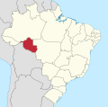
Acre (state) (redirect from BR-AC)
from BR-317 in Brasileia to Ruta 13 in Cobija. One road to Amazonas: BR-317, plus BR-364 passes through Amazonas. One road to Rondônia: BR-364 (via Amazonas)...
54 KB (5,344 words) - 12:34, 4 September 2024

by BR 364. Highway connections from Goiânia are made by BR-060 / Abadia de Goiás / Guapó / Indiara / Acreúna / Rio Verde / Jataí / GO-050 / BR-364. See...
8 KB (813 words) - 18:40, 20 August 2024

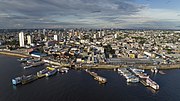
Brazilian road network in Rio Branco, via the BR-317, in this case, the road leading to the Atlantic, being the BR-364, connecting São Paulo to elsewhere. The...
12 KB (1,146 words) - 13:50, 15 August 2024

Northern Brazil, and the 38th busiest airport in the country. The BR-364 and the BR-317 (Interoceanic Highway) are the main highways in Acre, and the...
33 KB (2,898 words) - 00:40, 16 August 2024
continuously from Manaus into Venezuela, and then reenter Brazil through the BR-364 in Acre and its capital, Rio Branco, therefore passing through the countries...
85 KB (8,138 words) - 09:15, 23 September 2024

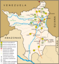
BR-174 is a federal highway of Brazil. The 3,321 km (2,064 mi) road connects Cáceres to Pacaraima on the Venezuelan border. It is the only road connection...
7 KB (362 words) - 09:23, 26 August 2024

Mato Grosso (redirect from BR-MT)
Grosso do Sul. Some of the main roads are: BR-070 BR-173 BR-174 BR-158 BR-163 BR-197 BR-242 BR-252 BR-364 MT-100 MT-358 Marechal Rondon International...
35 KB (2,810 words) - 18:15, 22 September 2024

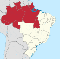
Amazonas (Brazilian state) (redirect from BR-AM)
One road to Rondônia state: BR-319. One road to Acre state: BR-317, plus BR-364 from Rondônia to Acre passes through Amazonas for 8.6 km. The state also...
61 KB (6,476 words) - 12:35, 4 September 2024

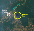
the Brazilian Air Force, is located in Porto Velho. BR-174; BR-317; BR-319; BR-364; BR-421; BR-425; BR-429; RO-010; RO-101; RO-490. Universidade Federal...
31 KB (2,506 words) - 23:44, 23 September 2024
important ones are the BR-364, the Interoceanic Highway, running through Acre into Peru, the BR-010 connecting Belém to Southern Brazil, and BR-174 connecting...
21 KB (1,837 words) - 19:43, 3 September 2024

one of the main highways in the interior of Brazil together with BR-163 and BR-364. The highway is extremely important for states like Mato Grosso, the...
13 KB (1,421 words) - 18:44, 19 November 2023

deforestation expands along smaller illegally built roads stemming from the BR-364 highway. The city is served by José Coleto Airport. The municipality contains...
6 KB (444 words) - 10:43, 10 November 2023
numbered 364: BR-364 Manitoba Provincial Road 364 Newfoundland and Labrador Route 364 Quebec Route 364 Saskatchewan Highway 364 Japan National Route 364 Arizona...
2 KB (136 words) - 23:19, 4 April 2024

Pacific Ocean with the Interoceanic Highway, and to the Atlantic Ocean by the BR-364 Highway. A 22-kilometer (14 mi) light rail line, that would connect Cuiabá...
36 KB (3,319 words) - 22:05, 7 September 2024

The town is about 630 kilometres from Rio Branco by road, through the BR-364. The urban area of Cruzeiro do Sun has a size of 24.794 square kilometres...
17 KB (983 words) - 15:07, 16 August 2024

Canal rendered it uneconomical. It was kept in operation until 1972. The BR-364 road eventually subsumed the route as railway bridges were taken over, leaving...
5 KB (413 words) - 10:58, 11 September 2024
POLONOROESTE project funded by the World Bank that rebuilt and paved the BR-364 highway and opened Rondônia to a flood of migrants from the state of Paraná...
15 KB (1,639 words) - 13:47, 23 October 2023

Rio Branco and BR-364 in 2000 showing "herringbone" patterns of deforestation...
34 KB (3,740 words) - 15:42, 22 September 2024
flows in a north of northeast direction from the park, passing under the BR-364 highway and flowing north into Amazonas state, where it joins the Tarauacá...
2 KB (123 words) - 13:31, 17 February 2023

caused the population to increase in 1959 after the construction of highway BR-364, which connects the north with the rest of the country and was paved in...
8 KB (875 words) - 14:28, 15 August 2024

do Oeste. BR-163 / 364, duplicate section between Cuiabá and Rondonópolis BR-163 / 364, duplicate section between Cuiabá and Rondonópolis BR-163, duplicate...
8 KB (819 words) - 19:42, 12 May 2024
area of 216,062 hectares (533,900 acres). The forest is bounded by the BR-364 highway to the south and the border with the state of Amazonas to the north...
6 KB (594 words) - 18:58, 13 December 2023
Gregório River, which separates it from the Rio Gregório State Forest. The BR-364 highway forms the southern boundary. The Rio Liberdade State Forest and...
4 KB (422 words) - 19:03, 13 December 2023
forced off their traditional homelands by ranchers after the construction of BR-364 in the 1960s. "Introduction: Kwazá." Povos Indígenas no Brasil. Retrieved...
2 KB (157 words) - 09:55, 6 February 2022
the Kwaza people lost many of their members due to the opening of the BR-364, an inter-state highway in Brazil connecting the southeast states to the...
52 KB (5,016 words) - 08:29, 14 September 2024
Araguaia River and is connected to the state capital, Goiânia by highway BR-364. It is 91 kilometers west of regional center, Mineiros. The distance to...
5 KB (362 words) - 18:27, 20 February 2022