
be divided into three geographic regions: eastern South Dakota, western South Dakota, and the Black Hills. Eastern South Dakota is lower in elevation...
66 KB (5,954 words) - 22:49, 25 August 2024
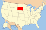
South Dakota, South Dakotan Demonym: South Dakotan Geography of South Dakota South Dakota is: a U.S. state, a federal state of the United States of America...
15 KB (1,314 words) - 03:33, 27 June 2024

The Geography of North Dakota consists of three major geographic regions: in the east is the Red River Valley, west of this, the Missouri Plateau. The...
6 KB (837 words) - 19:49, 11 July 2024

The Dakotas, also known as simply Dakota, is a collective term for the U.S. states of North Dakota and South Dakota. It has been used historically to...
11 KB (1,139 words) - 20:01, 4 May 2024
seat List of towns in South Dakota List of townships in South Dakota List of census-designated places in South Dakota "US Board on Geographic Names". United...
47 KB (137 words) - 15:42, 22 August 2024
South Dakota lies in both the Mountain Time Zone and the Central Time Zone. Mountain Time contains most of the western half of the state, including Mount...
1 KB (99 words) - 01:41, 3 September 2024
population of about 213,900, is South Dakota's most populous city. The state is bisected by the Missouri River, dividing South Dakota into two geographically and...
156 KB (13,087 words) - 15:40, 5 September 2024
states of North Dakota and South Dakota. About 70 percent of the drainage area is in South Dakota. The river provides the main drainage of the flat...
8 KB (560 words) - 07:05, 22 May 2024

(Lakota: Čhaŋšúška Wakpá) is a tributary of the Missouri River in South Dakota in the United States. The length of the combined branch is 110 mi (177 km)...
8 KB (500 words) - 02:30, 16 May 2024

and county seat of Moody County, South Dakota, United States. The population was 2,372 at the 2020 census. It was named in honor of Charles Eugene Flandrau...
21 KB (1,427 words) - 01:06, 23 August 2024
South Dakota State University (SDSU or SD State) is a public land-grant research university in Brookings, South Dakota. Founded in 1881, it is the state's...
40 KB (3,919 words) - 18:23, 18 August 2024
city in Stanley County, South Dakota, United States. It is part of the Pierre, South Dakota micropolitan area and the county seat of Stanley County. The population...
16 KB (1,441 words) - 15:30, 30 August 2024

counties in the U.S. state of South Dakota with FIPS codes. Todd County and Oglala Lakota County are the only counties in South Dakota which do not have their...
22 KB (736 words) - 17:44, 16 August 2024
The history of South Dakota describes the history of the U.S. state of South Dakota over the course of several millennia, from its first inhabitants to...
50 KB (6,321 words) - 10:20, 15 August 2024

Otȟuŋwahe, "Town alongside the Badlands") is a town in Pennington County, South Dakota, United States. The population was 699 at the 2020 census. Wall was platted...
14 KB (979 words) - 00:06, 7 May 2024

tributary of the Missouri River, approximately 161 miles (259 km) long, in central South Dakota in the United States. The river is formed at Philip, South Dakota...
4 KB (466 words) - 08:30, 15 June 2022

approve or confirm things") is a city that serves as county seat of Lawrence County, South Dakota, United States. It was named by early settlers after the dead...
47 KB (4,387 words) - 15:23, 11 September 2024

Point is a city in and the county seat of Union County, South Dakota, United States. The population was 2,149 as of the 2020 census. The British established...
11 KB (968 words) - 16:55, 7 August 2024

a city in Meade County, South Dakota, United States. The population was 7,020 as of the 2020 census. It is the county seat of Meade County and is named...
21 KB (1,476 words) - 19:27, 22 August 2024

Pierre (/pɪər/ PEER) is the capital city of the U.S. state of South Dakota and the county seat of Hughes County. The population was 14,091 at the 2020...
30 KB (2,218 words) - 17:07, 30 August 2024

River is a tributary of the Missouri River, 96 miles (154 km) long, in eastern South Dakota in the United States. The origin of the river name is Waséoyuze...
6 KB (284 words) - 20:34, 1 July 2023
of lakes in South Dakota. Swimming, fishing, and/or boating are permitted in some of these lakes, but not all. Lakes portal List of rivers of South Dakota...
30 KB (108 words) - 04:25, 30 April 2023

Keystone is a town in the Black Hills region of Pennington County, South Dakota, United States. The population was 240 at the 2020 census. It had its origins...
13 KB (972 words) - 21:01, 11 June 2024

U.S. Geological Survey Geographic Names Information System: Caputa, South Dakota "U.S. Census Bureau: Caputa CDP, South Dakota". www.census.gov. United...
5 KB (97 words) - 22:33, 24 July 2024

county seat of Brookings County, South Dakota, United States. Brookings is South Dakota's fourth most populous city, with a population of 23,377 at the...
29 KB (2,306 words) - 01:04, 23 August 2024

Lawrence County, South Dakota, United States. The population was 2,982 at the 2020 census. Lead is located in western South Dakota, in the Black Hills...
27 KB (2,070 words) - 10:41, 12 March 2024
in South Dakota Geography of South Dakota Category:Geography of South Dakota commons:Category:Geography of South Dakota Geology of South Dakota...
18 KB (1,734 words) - 21:36, 9 March 2024
unincorporated community and census-designated place (CDP) in Fall River County, South Dakota, United States. The town was founded in 1889 by European-American settlers...
4 KB (333 words) - 22:28, 21 May 2024

seat of Yankton County, South Dakota, United States. The population was 15,411 at the 2020 census, making it the 7th most populous city in South Dakota, and...
54 KB (4,800 words) - 03:38, 2 September 2024
corner of the U.S. state of South Dakota. The population was 4,020 at the 2020 census. As of the census of 2020, there were 4,020 people. As of the census...
7 KB (389 words) - 10:18, 29 June 2024