Indira Col West (Hindi: इंदिरा कोल पश्चिम) is a mountain pass at 5,988 metres (19,646 ft)) altitude on the Indira Ridge of Siachen Muztagh in Karakoram...
15 KB (1,401 words) - 20:38, 28 March 2024
Manirathnam Indira is a byname of Lakshmi, the Hindu goddess of prosperity, good luck, and beauty Indira Col, a col in the Karakoram mountains Indira Marathon...
704 bytes (117 words) - 20:01, 1 April 2023

20 day trek for troops. Pahalwan Post (about 20,000 ft) and posts near Indira Col (about 19,000 ft) are other high posts. Kumar Post or Kumar Base, named...
13 KB (1,361 words) - 14:23, 17 February 2024

from an altitude of 5,753 m (18,875 ft) above sea level at its head at Indira Col on the India–China border down to 3,620 m (11,875 ft) at its terminus...
44 KB (4,196 words) - 05:36, 24 June 2024

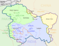
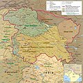
point in India is Indira Point on Great Nicobar Island. The northernmost point which is under Indian administration is Indira Col, Siachen Glacier. India's...
79 KB (8,732 words) - 01:07, 7 June 2024
the north on the Indira Ridge at the India-China-Pakistan LAC tripoint near Sia Kangri about 4 km (2.5 mi) northwest of Indira Col West, with peaks in...
23 KB (2,366 words) - 02:53, 24 June 2024

is on the watershed between the Indus River basin and the Tarim Basin. Indira Col which is 3 km to the east is India's northernmost point. Sia Kangri was...
3 KB (277 words) - 21:56, 13 June 2024

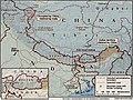
Actual Ground Position Line (AGPL) across Siachen from Point NJ9842 to Indira Col West. Siachen lies south of the Shaksgam ceded by Pakistan to China via...
11 KB (891 words) - 06:26, 5 October 2023
of Indira Col at Siachen Glacier Ladakh Xinjiang, China 35°40′28″N 76°50′40″E / 35.674521°N 76.844485°E / 35.674521; 76.844485 (Near Indira Col (Northernmost —...
10 KB (525 words) - 07:45, 22 June 2024
Indira Gandhi National Open University, known as IGNOU, is a public distance learning university located in New Delhi, India. Named after the former Prime...
19 KB (1,527 words) - 07:42, 3 July 2024

Glacier Saltoro Mountains Saltoro Kangri Ghent Kangri Bilafond La Sia La Indira Col, AGPL ends at LAC Borders Actual Ground Position Line (AGPL) India–Pakistan...
7 KB (743 words) - 17:04, 24 June 2024
Kangri, and Sia La to the India–Pakistan–China trijunction northwest of Indira Col West on the Sino-Indian LAC. The peaks and passes under Pakistan's control...
10 KB (1,069 words) - 03:56, 27 May 2023
of the Western Himalayas Siachen conflict Actual Ground Position Line Indira Col Sia La Ghent Kangri Saltoro Kangri Bilafond La Chumik Glacier Gyong La...
4 KB (344 words) - 00:35, 17 July 2024

from an altitude of 5,753 m (18,875 ft) above sea level at its source at Indira Col on the China border down to 3,620 m (11,880 ft) at its snout. Saser Kangri...
138 KB (13,433 words) - 17:32, 21 July 2024

Pradesh to the western part of the Himalayas at Siachen Glacier, reaching Indira Col, the northernmost tip of India at the altitude of 20,100 ft (6,126.5 m)...
14 KB (1,382 words) - 05:53, 12 July 2024

boat, since the tripoint is in the river) the summit of Sia Kangri (near Indira Col) is the tripoint where territories administered by India, Pakistan, and...
11 KB (1,183 words) - 03:51, 27 May 2024
Apostolos Andreas 35°42′N India Kilik Pass, Jammu and Kashmir (claimed) Indira Col, Ladakh 37°06′N (claimed) 35°40′N Lebanon North of Chadra 34°43′N Jordan...
29 KB (78 words) - 11:36, 24 June 2024
Glacier on the southwest, the Teram Shehr Glacier and Rimo Glacier, and Indira Col on the south, and the uppermost Yarkand River on the east. Its highest...
4 KB (254 words) - 17:39, 17 July 2024
Glacier Saltoro Mountains Saltoro Kangri Ghent Kangri Bilafond La Sia La Indira Col Borders Actual Ground Position Line (AGPL) India–Pakistan International...
20 KB (2,137 words) - 22:22, 17 July 2024

Glacier, India–Pakistan border, India – 70 km (43 mi) when measuring from Indira Col. or 76 km (47 mi) using the longest route as is done when determining...
16 KB (1,590 words) - 17:55, 26 May 2024

part in the initial action to secure Bila Fondla NJ 8888 Siala ND 7011 Indira Col and area North of Base Camp, through vertical envelopment. Personnel physically...
5 KB (436 words) - 07:18, 15 August 2023
The current de facto tripoint is about 100 km west of the pass near Indira Col in the Siachen Muztagh, where the Actual Ground Position Line between...
10 KB (902 words) - 10:59, 12 April 2024
↓Galwan ↓Depsang ↓1962 war Major border events: ↓Tulung La Indian PM: Nehru Indira Gandhi I. Gandhi R. Gandhi Narasimha Rao Vajpayee Manmohan Singh Narendra...
109 KB (9,485 words) - 17:39, 24 June 2024
Glacier Saltoro Mountains Saltoro Kangri Ghent Kangri Bilafond La Sia La Indira Col, AGPL ends at LAC Borders Actual Ground Position Line (AGPL) India–Pakistan...
20 KB (2,025 words) - 02:36, 16 June 2024
spread all through the area of Siachen with Capt. Roshan Lal Yadav at the Indira Col, Maj. Shashi Kant Mahajan and Maj. Darshan Lal Julka on the Central Glaciers...
48 KB (5,724 words) - 19:37, 22 July 2024

Markha Galwan Chip Chap Passes Bilafond La Chang la Fotu La Gyong La Indira Col Karakoram Pass Khardung La Kongka Pass Lachulung La Taglang La Marsimik...
3 KB (230 words) - 12:12, 30 October 2023
(mountain) (peak) Bilafond La Saltoro Valley Ghent Kangri Sia La Sia Kangri Indira Col Borders Actual Ground Position Line (AGPL) India–Pakistan International...
20 KB (2,521 words) - 18:09, 12 July 2024

spent the entire time over 15,000 feet (4,600 m), the high point being Indira Col, which they summitted and named. On this expedition, one of their Italian...
51 KB (6,638 words) - 03:57, 7 June 2024

the age of 45 from Siachen Base Camp to Kumar Base (16,000 ft), Indira Ridge, Indira Col (extreme northwestern point of India administered area) and other...
43 KB (4,314 words) - 13:52, 2 July 2024
Gyong La Saltoro Mountains Saltoro Kangri Ghent Kangri Bilafond La Sia La Indira Col, AGPL ends at LAC Chumik Kangri Borders Actual Ground Position Line (AGPL)...
6 KB (418 words) - 20:13, 24 April 2024