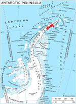
Larsen Inlet (64°26′S 59°26′W / 64.433°S 59.433°W / -64.433; -59.433 (Larsen Inlet)) is an inlet, formerly ice-filled, 12 nautical miles (22 km; 14 mi)...
12 KB (1,935 words) - 20:49, 4 September 2024
the Scar Inlet Ice Shelf," according to NASA scientists examining images from the Terra and Aqua satellites. As of July 2017[update], Larsen C was the...
28 KB (2,911 words) - 08:16, 14 November 2024
wide and projects southward into the northern part of the Larsen Ice Shelf west of Larsen Inlet. The Sobral Peninsula lies towards the east end of the Nordenskjöld...
6 KB (867 words) - 15:44, 31 May 2024
seven kilometres (four nautical miles) east of the northeast corner of Larsen Inlet. The Downfall, located between the heads of Arago Glacier and Woodbury...
5 KB (482 words) - 12:35, 3 October 2024
December 2018, Larsen attempted to be the Solo unsupported, unassisted speed record from Hercules Inlet to the South Pole in Antarctica. Larsen encountered...
7 KB (659 words) - 03:38, 19 November 2024
Antarctic Peninsula. It is at the northeast end of Nordenskjold Coast. Larsen Inlet is to the west of the peninsula, the Weddell Sea to the south and Prince...
5 KB (641 words) - 23:17, 26 August 2024
direction and 1.3 km wide, rising to 697 m at the northwest coast of Larsen Inlet on Nordenskjöld Coast in Graham Land, Antarctica. The feature is named...
2 KB (236 words) - 09:25, 2 November 2024
The Scar Inlet is an area of the Larsen Ice Shelf immediately northwest of Jason Peninsula, named after the Scientific Committee on Antarctic Research...
2 KB (208 words) - 12:46, 27 June 2024
Henry Asbjørn Larsen (September 30, 1899 – October 29, 1964) was a Norwegian-Canadian Arctic explorer. Larsen was born on a small island, Herføl, south...
8 KB (1,017 words) - 02:05, 10 November 2024
The Larsen Glacier (75°6′S 162°28′E / 75.100°S 162.467°E / -75.100; 162.467) is a glacier flowing southeast from Reeves Névé, through the Prince Albert...
6 KB (687 words) - 21:06, 1 March 2024
Sjögren Glacier (redirect from Sjögren Inlet)
It is north of Mount Tucker and Longing Peninsula, and northeast of Larsen Inlet. Mount Hornsby looks over its western side. Copernix satellite image...
14 KB (2,208 words) - 01:49, 7 August 2024
Hollick-Kenyon Peninsula (redirect from Revelle Inlet)
is surrounded by the Larsen Ice Shelf. Bowman Inlet is immediately to the west, and Mobiloil Inlet is further west. Casey Inlet is to the south. The arc...
7 KB (922 words) - 23:17, 26 August 2024
Coast of Antarctica. The inlet is 5 nautical miles (9 km) wide, recedes 12 nautical miles (22 km), and opens to the Riiser-Larsen Ice Shelf. It was plotted...
1 KB (159 words) - 12:23, 19 August 2020
Terra Nova Bay (redirect from Gerlache Inlet)
the Nansen Ice Sheet. The Larsen Glacier enters the bay to the south of the Nansen Ice Sheet, flowing towards Relief Inlet, which defines the south of...
11 KB (1,549 words) - 19:27, 21 July 2024
Evans Glaciers, which followed the calving of the Larsen Ice Shelf in the area in March 2002. The inlet was named by UK-APC in 2008 after David G. Vaughan...
2 KB (239 words) - 18:43, 23 April 2023
Adie Inlet (66°25′S 62°20′W / 66.417°S 62.333°W / -66.417; -62.333) is an ice-filled inlet, 25 miles (40 km) long in a northwest–southeast direction...
2 KB (209 words) - 23:05, 22 April 2023
Some of Skelton's claims have been challenged. In December 2012, Eric Larsen made the first attempt to undertake an expedition solely by bicycle to the...
10 KB (986 words) - 04:48, 20 September 2024
Violante Inlet (72°35′S 61°5′W / 72.583°S 61.083°W / -72.583; -61.083 (Violante Inlet)) is an ice-filled inlet 16 nautical miles (30 km; 18 mi) long...
9 KB (1,506 words) - 00:23, 27 April 2024
Drescher Inlet, also known as Dreschereisfrontkerbe, is an inlet or iceport in the front Riiser-Larsen Ice Shelf on the coast of Queen Maud Land, Antarctica...
2 KB (143 words) - 12:28, 11 August 2024
shallow part of the sea, located in Denmark where it has been regarded as an inlet ever since Viking times. However, it now has entries both from the North...
11 KB (1,447 words) - 00:20, 25 October 2024
fiord in New Zealand English; (/ˈfjɔːrd, fiːˈɔːrd/ ) is a long, narrow sea inlet with steep sides or cliffs, created by a glacier. Fjords exist on the coasts...
53 KB (6,188 words) - 02:23, 7 November 2024
on Larsen C Ice Shelf, The Cryosphere, 11, 2743–2753, 2017 https://doi.org/10.5194/tc-11-2743-2017 Whirlwind Inlet on USGS website Whirlwind Inlet on...
2 KB (244 words) - 18:43, 23 April 2023
Larsen led the first Norwegian expedition to Antarctica aboard the ship Jason. Larsen became the first person to ski in Antarctica where the Larsen Ice...
55 KB (6,291 words) - 12:42, 23 November 2024
his expedition, "The South Pole Epic", on December 2, 2013, at Hercules Inlet and arrived at the South Pole on January 21, 2014. Burton was a computer...
6 KB (416 words) - 23:15, 22 November 2024
surrounded by the Larsen Ice Shelf. The Hollick-Kenyon Peninsula and Revelle Inlet are to the east. Casey Glacier and Casey Inlet in Palmer Land are...
11 KB (1,747 words) - 03:22, 8 May 2024
into the Nansen Ice Sheet. Further south, they cross the David Glacier and Larsen Glacier. In the far south they extend to the Mawson Glacier. In the southwest...
8 KB (993 words) - 12:38, 28 July 2024
Cabinet Inlet (66°35′S 63°10′W / 66.583°S 63.167°W / -66.583; -63.167) is an icy inlet, 36 miles (58 km) long in a northwest–southeast direction, and...
2 KB (204 words) - 23:06, 22 April 2023
Larsen Harbour (Spanish: Bahía Larsen) is a narrow 2.6 miles (4.2 km) long inlet of indenting volcanic rocks and sheeted dykes known as the Larsen Harbour...
7 KB (676 words) - 20:40, 27 October 2024
Cove – a small, typically sheltered bay with a relatively narrow entrance Inlet – a narrow and long bay similar to a land peninsula, but adjoining the sea...
24 KB (2,768 words) - 15:26, 24 October 2024
tip) Cape Felix, Victory Point and Gore Point at the mouth of Collinson Inlet, Point Le Vesconte, Erebus Bay, Cape Crozier, (south side) Terror Bay, Irving...
18 KB (1,329 words) - 19:22, 14 November 2024


