
The Ozarks, also known as the Ozark Mountains, Ozark Highlands or Ozark Plateau, is a physiographic region in the U.S. states of Missouri, Arkansas, Oklahoma...
68 KB (6,903 words) - 19:06, 13 September 2024
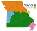
Geography of Missouri (section Ozark Plateau)
(areas 3e) or the Mississippi embayment the Missouri portion of the Ozark Plateau (areas 14a and 14b) which lies between the Mississippi Alluvial Plain...
16 KB (1,929 words) - 13:20, 13 June 2024

alleganiensis). The subspecies is strictly native to the mountain streams of the Ozark Plateau in southern Missouri and northern Arkansas. Its nicknames include lasagna...
21 KB (2,556 words) - 16:06, 19 April 2024

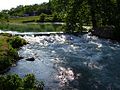
The spring is by far the largest spring in the Ozark Plateau region. The only two springs in the Ozark region that approach the size of Big Spring are...
6 KB (461 words) - 23:03, 26 November 2023

is a first magnitude spring located in the southeast portion of the Ozark Plateau, in Oregon County in south-central Missouri within the boundaries of...
8 KB (622 words) - 19:20, 13 April 2024
in the Ozark Plateau within the state of Arkansas. It is the largest spring in Arkansas and the third-largest spring within the Ozark Plateau region behind...
8 KB (690 words) - 10:06, 22 December 2023
Allegheny Plateau, the Cumberland Plateau, the Ozark Plateau, and the Catskill Mountains in the United States, the Blue Mountains and Hornsby Plateau in Australia...
5 KB (454 words) - 14:45, 4 August 2024

Hamamelis vernalis (redirect from Ozark witchhazel)
vernalis, the Ozark witchhazel (or witch-hazel) is a species of flowering plant in the witch-hazel family Hamamelidaceae, native to the Ozark Plateau in central...
4 KB (501 words) - 03:14, 17 February 2023

southeastern portion of the Ozarks of Missouri and becomes a 7th order stream as it flows southeasterly out of the Ozarks into northeastern Arkansas where...
10 KB (836 words) - 02:54, 25 July 2023

Geology of Kansas (section Ozark plateau)
different physiographic regions. Mississippian limestones and cherts of the Ozark Plateau are exposed in extreme southeastern Kansas in Cherokee County. This...
18 KB (2,238 words) - 08:56, 14 July 2024

St. Francois Mountains (category Landforms of the Ozarks)
are a mountain range of Precambrian igneous mountains rising over the Ozark Plateau. This range is one of the oldest exposures of igneous rock in North...
14 KB (1,393 words) - 07:23, 8 December 2023
This is a list of natural springs in the Ozark Plateau ordered by spring magnitude. Different sources may give differing values for average daily flow...
8 KB (367 words) - 18:47, 9 February 2024
the interior continental United States, this division includes the Ozark Plateau, the Ouachita Mountains, and other smaller mountain systems. This region...
49 KB (5,624 words) - 23:03, 18 July 2024
of eastern Texas, and stretches west through the Ouachita Mountains, Ozark Plateau, eastern Iowa, and southeastern Minnesota. It is bounded on the north...
2 KB (138 words) - 22:45, 16 July 2022

Boston Mountains (category Ozark–St. Francis National Forest)
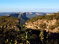
Part of the Ozarks, the Boston Mountains are a deeply dissected plateau. The ecoregion is steeper than the adjacent Springfield Plateau to the north...
13 KB (1,126 words) - 15:37, 3 January 2024

United States. Jefferson City is located on the northern edge of the Ozark Plateau on the southern side of the Missouri River in a region known as Mid-Missouri...
43 KB (3,529 words) - 18:08, 15 September 2024

boundaries, but does overlap state lines, is the Ozarks, a bioregion also referred to as the Ozarks Plateau, which consists of southern Missouri, northwest...
43 KB (4,771 words) - 23:57, 1 September 2024

6 square miles (9.3 km2) (0.6%) is water. The county is part of the Ozark plateau uplift, the tree-covered foothills of the Boston Mountains. North and...
17 KB (1,191 words) - 22:17, 26 April 2024

dissected Ozark plateau of southern Missouri and northern and central Arkansas. The southern Missouri and northern Arkansas Ozark plateau resembles in...
20 KB (2,830 words) - 01:33, 29 June 2024

Ouachita Mountains (section Athens Plateau)
join with the Marathon uplift area of West Texas. Together with the Ozark Plateaus, the Ouachitas form the U.S. Interior Highlands. The highest natural...
26 KB (2,530 words) - 16:43, 21 July 2024

treaties of the early 1800s. Oklahoma is between the Great Plains and the Ozark Plateau in the Gulf of Mexico watershed, generally sloping from the high plains...
216 KB (18,613 words) - 12:18, 16 September 2024
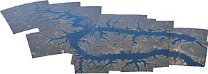
Lake of the Ozarks is a reservoir created by impounding the Osage River in the northern part of the Ozarks in central Missouri. Parts of three smaller...
34 KB (3,192 words) - 22:55, 13 September 2024
U.S. Interior Highlands (category Ozark–St. Francis National Forest)
subregions of the Ouachita Mountains south of the Arkansas River and the Ozark Plateaus north of the Arkansas. The U.S. Interior Highlands is one of few mountainous...
5 KB (288 words) - 21:06, 2 September 2024

Originally known as the Oklahoma Bat Caves National Wildlife Refuge, Ozark Plateau National Wildlife Refuge was established for the protection of endangered...
2 KB (123 words) - 02:59, 7 January 2020

Osage River (category Bodies of water of the Ozarks)
west-central and central Missouri, where it drains northwest areas of the Ozark Plateau. The river flows generally easterly, then northeasterly for the final...
9 KB (754 words) - 03:54, 8 August 2024

native to the central United States, primarily in the Great Plains and Ozark Plateau (states of Missouri, Kansas, Oklahoma, and Texas). There are a few reports...
2 KB (203 words) - 20:05, 14 July 2021
regions, ranging from the flat-topped hills and steep valleys of the Ozark Plateau to the flat bottomland and tallgrass prairies of the Mississippi alluvial...
2 KB (157 words) - 19:01, 3 June 2023

Spring is located on the Meramec River near St. James in the east-central Ozarks of Missouri. The fifth largest spring in the state with an average discharge...
9 KB (623 words) - 23:45, 28 August 2024

to the West" when settlement was expanding. The northern edge of the Ozark Plateau was settled chiefly by mid-to-late 19th century German immigrants, who...
108 KB (12,670 words) - 17:09, 13 September 2024

St. Francis River (category Bodies of water of the Ozarks)
mountains in Iron County, Missouri, and flows generally southwardly through the Ozarks and the St. Francois Mountains near Missouri's highest point Taum Sauk....
10 KB (767 words) - 00:51, 6 April 2024