
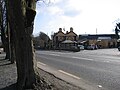
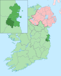
Saggart (Irish: Teach Sagard) is a village in County Dublin, Ireland, south west of Dublin city, in the local government area of South Dublin. It lies...
8 KB (807 words) - 23:17, 6 May 2024
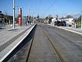
Saggart (Irish: Teach Sagard) is a stop on the Luas light-rail tram system in Dublin, Ireland. It opened in 2011 as the terminus of an extension of the...
3 KB (184 words) - 20:48, 5 July 2024

before travelling southwest to Tallaght, with a fork to Citywest and Saggart. The Red Line opened on 26 September 2004. Construction work began in March...
22 KB (431 words) - 17:11, 23 August 2024

the civil parish of Rathcoole, one in a field between the village and Saggart village. There is no definite explanation for the name "Rathcoole", but...
12 KB (1,229 words) - 17:41, 10 June 2024
St Mary's GAA (Dublin) (redirect from St Marys, Saggart)
St Mary's is a Gaelic Athletic Association club based in Saggart, County Dublin, Ireland. Mary's have won the Dublin Senior Football Championship on one...
2 KB (160 words) - 02:36, 1 April 2024

John's Road West is for southbound trams travelling towards Tallaght and Saggart. The eastern side of the island is a terminus platform, used only in certain...
34 KB (2,600 words) - 13:49, 31 July 2024
the Citywest Hotel and Golf Resort, several developments local to the Saggart, Citywest and Tallaght areas, and Weston Airport. Mansfield had been involved...
9 KB (818 words) - 23:01, 29 July 2023
major suburban centre is Tallaght, while the semi-suburban village of Saggart is adjacent. It is 13 km south-west of Dublin city centre. Citywest was...
11 KB (1,110 words) - 18:08, 9 July 2024
originates close to Brittas before descending through the Slade of Saggart to Saggart and beyond. Brittas is in the foothills of the Dublin Mountains, 18 km...
13 KB (1,256 words) - 07:42, 27 June 2024
runs to Saggart. Originally intended to be a spur of the proposed Red Line as far as Fortunestown, it was later decided to extend it to Saggart. Construction...
65 KB (7,079 words) - 15:13, 20 August 2024
Eircom Park was the name of a proposed association football stadium in Saggart, Dublin, intended to be the home of the Republic of Ireland national football...
3 KB (285 words) - 04:46, 24 June 2024

Docklands and city centre with the south-western suburbs of Tallaght and Saggart, while the Green Line connects northern inner city suburbs and the main...
173 KB (16,252 words) - 22:12, 11 September 2024
Rathgar Rathmichael Rathmines Rialto Ringsend Rockbrook Rolestown Rush Saggart Sallynoggin Sandycove Sandyford Sandymount Santry Shankill Skerries Smithfield...
5 KB (262 words) - 11:02, 20 February 2024

for huge amounts of fresh water to service the Swiftbrook Paper Mills in Saggart village, approximately 4 kilometres downstream, and three other mills,...
11 KB (1,229 words) - 17:15, 20 June 2024
Rathcoole Rathfarnham Rathgar Rathmichael Rathmines Rialto Ringsend Rockbrook Saggart Sallynoggin Sandycove Sandyford Sandymount Shankill South Lotts, Ringsend...
13 KB (1,398 words) - 13:26, 22 August 2024
Ballycullen and Greenhills villages such as Rathcoole, Newcastle(-Lyons), and Saggart new neighbourhoods, some within bigger, older areas — including such as...
15 KB (1,408 words) - 11:58, 20 November 2023
Red Gap, also known as Saggart Hill or Slieve Thoul, is a hill 395 feet above sea level situated 16 kilometres southwest of Dublin city centre in the...
3 KB (203 words) - 03:33, 29 August 2024

industrial/agricultural area near Rathcoole, Clondalkin, Tallaght, Lucan, Saggart and Naas.[citation needed] It is around 15 km west of Dublin city centre...
2 KB (203 words) - 06:25, 19 May 2024
Rathcoole Rathfarnham Rathgar Rathmichael Rathmines Rialto Ringsend Rockbrook Saggart Sallynoggin Sandycove Sandyford Sandymount Shankill South Lotts, Ringsend...
4 KB (254 words) - 11:01, 24 February 2023
As a priest in the Dublin Diocese, O’Carroll served as parish priest of Saggart, Rathcoole, and Brittas. He worked in Clonliffe for the Archbishop of Dublin...
3 KB (267 words) - 10:03, 2 June 2023

continue along an abandoned canal alignment, travelling towards Tallaght or Saggart. In 2007, a proposal was announced for a Luas line from the city centre...
3 KB (250 words) - 18:52, 6 July 2024

years prior to that it was known as Saggart's Field after a local family. A school built in 1866 was named Saggart Field School although it was renamed...
4 KB (305 words) - 17:38, 4 August 2024

the old tower of much earlier origin was preserved. Crumlin, along with Saggart, Newcastle, Lyons and Esker (Lucan), was constituted a royal manor by King...
13 KB (1,594 words) - 05:09, 20 August 2024

network currently comprises two lines: Red Line – The Point or Connolly to Saggart or Tallaght (each route is approximately 20.7 kilometres (12.9 mi) long...
85 KB (8,744 words) - 02:32, 16 August 2024

sheet of paper. The paper was sourced from the Swift Brook Paper Mills in Saggart. The typesetters were Willie O'Brien, Michael Molloy, and Christopher Brady...
16 KB (2,034 words) - 13:09, 26 April 2024
Dumhach) Roundstone Roundwood Royal Oak Ruan Rush Rushbrooke Rylane Rialto Saggart Salia (Sáile) Sallins Sallybrook Sallynoggin Salthill Saltmills Sandpit...
33 KB (1,939 words) - 16:52, 20 July 2024

Kilcock, Clane, Naas, Harristown, Ballymore Eustace, Rathmore, Kilteel, Saggart, Tallaght and Dalkey. The northern frontier of the Pale was marked by the...
17 KB (2,148 words) - 22:59, 13 August 2024

Ireland. It opened in 2011 as a stop on the extension of the Red Line to Saggart. The stop is located on a section of reserved track at the side of Katherine...
2 KB (92 words) - 10:01, 28 June 2024

Rathcoole Rathfarnham Rathgar Rathmichael Rathmines Rialto Ringsend Rockbrook Saggart Sallynoggin Sandycove Sandyford Sandymount Shankill South Lotts, Ringsend...
45 KB (5,084 words) - 12:39, 9 September 2024

[citation needed] Water to power the mill came from Brittas ponds via Saggart. A focal point for Clondalkin is the eighth-century round tower, one of...
32 KB (3,036 words) - 17:00, 12 August 2024