
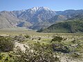
The San Gorgonio Pass, or Banning Pass, is a 2,600 ft (790 m) elevation gap on the rim of the Great Basin between the San Bernardino Mountains to the...
10 KB (958 words) - 12:55, 20 August 2024

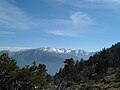
San Gorgonio Mountain, also known locally as Mount San Gorgonio, or Old Greyback, is the highest peak in Southern California and the Transverse Ranges...
13 KB (1,199 words) - 07:56, 24 May 2024

The San Gorgonio Pass wind farm is a wind farm that stretches from the eastern slope of the San Gorgonio Pass, near Cabazon, to North Palm Springs, on...
17 KB (1,882 words) - 23:19, 12 August 2024
serves as the southern border of the San Gorgonio Pass. Naturalist John Muir wrote of San Jacinto Peak, "The view from San Jacinto is the most sublime spectacle...
14 KB (1,342 words) - 02:28, 25 July 2024

northern Riverside County, Southern California. It begins north of San Gorgonio Pass, approximately 2 miles (3.2 km) west of Morongo Valley and 10 miles...
5 KB (320 words) - 00:24, 1 November 2021
Coachella Valley–San Gorgonio Pass Rail Corridor Service is an effort by the Riverside County Transportation Commission (RCTC) to start regular passenger...
8 KB (622 words) - 16:34, 11 December 2023
The San Gorgonio River is a 26.8-mile-long (43.1 km) river primarily flowing in western Riverside County, with a small upstream section in southwestern...
2 KB (239 words) - 01:50, 7 July 2023
San Gorgonio is Spanish for "Saint Gorgonius"; San Gorgonio might also refer to: San Gorgonio Mountain, California, United States San Gorgonio Pass, California...
2 KB (209 words) - 00:32, 22 October 2022
Beaumont, California (redirect from San Gorgonio, California)
summit of the San Gorgonio Pass, between the San Bernardino Mountains and Mount San Gorgonio to the north, and the San Jacinto Mountains and San Jacinto Peak...
41 KB (3,407 words) - 23:06, 14 August 2024
range tops out at 11,503 feet (3,506 m) at San Gorgonio Mountain – the tallest peak in Southern California. The San Bernardinos form a significant region of...
43 KB (4,659 words) - 16:10, 22 October 2023
Rancho San Gorgonio, or San Gorgonio Rancho, might refer to; Rancho San Gorgonio, a cattle ranch established in the San Gorgonio pass in 1824 by the San Gabriel...
615 bytes (94 words) - 23:24, 4 October 2020

The valley extends approximately 45 mi (72 km) southeast from the San Gorgonio Pass to the northern shore of the Salton Sea and the neighboring Imperial...
94 KB (10,486 words) - 05:10, 23 June 2024

Inland Empire (redirect from Riverside-San Bernardino-Ontario, CA MSA)
Coachella and Victor Valleys, respectively on the other sides of the San Gorgonio Pass and San Bernardino Mountains from the Santa Ana River watershed that forms...
113 KB (10,465 words) - 04:32, 14 August 2024

southern base of the San Bernardino Mountains, crosses through the Cajon Pass and continues northwest along the northern base of the San Gabriel Mountains...
39 KB (3,839 words) - 23:39, 16 August 2024

from 29,603 at the 2010 census. It is situated in the San Gorgonio Pass, also known as Banning Pass. It is named for Phineas Banning, stagecoach line owner...
32 KB (3,098 words) - 17:13, 16 June 2024

2010 census, up from 7,139 at the 2000 census. It is situated in the San Gorgonio Pass. Historically, Calimesa began as a small rural town with mostly single-family...
25 KB (2,660 words) - 12:39, 22 August 2024

Gorgonius (category San Gorgonio Pass)
more. These include: San Gorgonio Pass, the site of the ranch San Gorgonio Mountain, an 11,500 foot peak north of the pass San Gorgonio River, a seasonal...
8 KB (926 words) - 16:55, 9 April 2024
complex setting along the San Andreas Fault Zone where it bisects San Gorgonio Mountain and San Jacinto Peak at the San Gorgonio Pass and was the first in...
15 KB (1,438 words) - 21:05, 14 August 2024
Cucamonga Valley San Jacinto Valley San Bernardino Valley San Bernardino Downtown San Bernardino Chino Valley Perris Valley San Gorgonio Pass San Bernardino...
6 KB (377 words) - 04:44, 5 May 2024

Morongo Band of Mission Indians (category San Gorgonio Pass)
Morongo Reservation is located in Riverside County, California in the San Gorgonio Pass. Established as the Portrero Reservation by executive order in 1876...
11 KB (1,250 words) - 19:24, 23 March 2024
consists of four locations: San Jacinto (San Jacinto Campus), Menifee (Menifee Valley Campus), Banning (San Gorgonio Pass Campus) and Temecula (Temecula...
26 KB (2,822 words) - 02:26, 23 February 2024
Bonnie Bell, California (category San Gorgonio Pass)
Whitewater River. The community sits where the most eastern end of the San Gorgonio Pass meets the most northwestern end of the Coachella Valley, 9.5 miles...
3 KB (313 words) - 14:24, 8 May 2024

eastward from Politana toward the San Gorgonio Pass and settled in a valley that branched off to the northeast from San Timoteo Canyon, at a village named...
26 KB (2,836 words) - 02:58, 8 June 2024

Cherry Valley, California (category San Gorgonio Pass)
2000 census. It is situated at the most northwestern point of the San Gorgonio Pass. The area was planted with many cherry trees, for which Cherry Valley...
17 KB (1,730 words) - 01:26, 13 August 2024

terminates at Lake Perris, in the area of the San Gorgonio Pass. It passes through parts of Kern, Los Angeles, San Bernardino, and Riverside counties. East...
31 KB (3,277 words) - 14:27, 24 July 2024

Gap – a mountain pass in Arkansas San Gorgonio Pass – California, separates Mount San Gorgonio and the Transverse ranges from Mount San Jacinto and the...
43 KB (3,236 words) - 20:26, 25 July 2024
recording equipment. Filming started on November 20, 2010, at the San Gorgonio Pass wind farm near Palm Springs, California. Teams were spotted at Oceanworld...
87 KB (8,921 words) - 03:42, 3 August 2024

areas of lower pressure and flatter land. Passes used for wind farms like the San Gorgonio Pass and Altamont Pass are known for their abundant wind resource...
79 KB (8,968 words) - 05:22, 31 July 2024

narrowest part of the canyon on the eastern approach to the summit (as at San Gorgonio Pass), where the elevation is about 3,771 feet (1,149 m). The actual high...
6 KB (484 words) - 13:30, 8 August 2024

Colorado River Aqueduct (category San Gorgonio Pass)
through the San Gorgonio Pass. Near Cabazon, the aqueduct begins to run underground until it enters the San Jacinto Tunnel at the base of the San Jacinto...
11 KB (1,112 words) - 17:36, 10 August 2023