
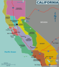
The Tehachapi Mountains (/təˈhætʃəpi/; Kawaiisu: Tihachipia, meaning "hard climb") are a mountain range in the Transverse Ranges system of California...
16 KB (1,667 words) - 20:58, 6 November 2023
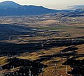
Tehachapi (/təˈhætʃəpi/ ; Kawaiisu: Tihachipia, meaning "hard climb") is a city in Kern County, California, United States, in the Tehachapi Mountains...
43 KB (4,104 words) - 13:20, 26 September 2024

Pacific Railroad Mojave Subdivision through Tehachapi Pass, of the Tehachapi Mountains in Kern County, south-central California. The line connects Bakersfield...
12 KB (1,115 words) - 13:19, 25 September 2024

Tehachapi Pass (Kawaiisu: Tihachipia, meaning "hard climb") is a mountain pass crossing the Tehachapi Mountains in Kern County, California. Traditionally...
6 KB (484 words) - 13:30, 8 August 2024

Bear Mountain is a peak in the Tehachapi Mountains, near Tehachapi, California. The mountain is north of Bear Valley Springs, and west of the Tehachapi Loop...
2 KB (153 words) - 05:27, 15 May 2023
Tehachapi may refer to: Tehachapi, California in the Tehachapi Mountains California Correctional Institution, colloquially referred to as "Tehachapi" Tehachapi...
1 KB (213 words) - 01:53, 1 June 2020

Route of California High-Speed Rail (section Bakersfield to Palmdale / the Tehachapi Mountains crossing)
route over the Tehachapi Pass begins in Bakersfield (elevation 404 feet (123 m)), crosses the valley floor and climbs over steeper mountains to the pass...
43 KB (3,849 words) - 13:53, 26 August 2024

runs across the Coast Ranges, the southern San Joaquin Valley, the Tehachapi Mountains, which border the southern Sierra Nevada, and the Mojave Desert....
34 KB (2,218 words) - 08:03, 15 September 2024

– California, separating the San Gabriel Mountains from the Santa Susana Mountains Pickle Gap – a mountain pass in Arkansas San Gorgonio Pass – California...
43 KB (3,236 words) - 22:19, 20 September 2024
Cache Creek (Kern County, California) (category Tehachapi Mountains)
intermittent creek flows seasonally from watersheds in the northeastern Tehachapi Mountains and southeastern Sierra Nevada foothills, and from infrequent rains...
1 KB (129 words) - 18:05, 4 September 2024
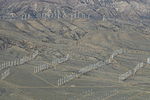
The Tehachapi Pass wind farm is one of the first large-scale wind farms installed in the U.S., with around 710 megawatts (950,000 hp) produced by about...
7 KB (619 words) - 22:46, 27 June 2023

include: Tehachapi Mountains — on the northeast Sierra Pelona Mountains — on the east Pine Mountain Ridge - (to the south) Topatopa Mountains — on the...
4 KB (364 words) - 17:08, 26 September 2022

At Edmonston Pumping Plant it is pumped 1,926 ft (587 m) over the Tehachapi Mountains. Water flows through the aqueduct in a series of abrupt rises and...
31 KB (3,277 words) - 14:27, 24 July 2024
Double Mountain is the highest point in the Tehachapi Mountains of California. It has two summits of nearly the same elevation. It is south of the town...
3 KB (205 words) - 18:15, 21 July 2024
The Tehachapi Wind Resource Area (TWRA) is a large wind resource area along the foothills of the Sierra Nevada and Tehachapi Mountains in California. It...
7 KB (463 words) - 09:32, 28 May 2023
Tejon Ranch (category Tehachapi Mountains)
over 270,000 acres (1,093 km2) in the southern San Joaquin Valley, Tehachapi Mountains, and Antelope Valley. It is the largest contiguous piece of private...
16 KB (1,764 words) - 12:09, 15 August 2024

Keene, California (category Tehachapi Mountains)
foothills of the Tehachapi Mountains at the southern extreme of the San Joaquin Valley. Keene is located 8.5 miles (14 km) northwest of Tehachapi, at an elevation...
14 KB (1,256 words) - 03:41, 23 September 2024

junction of the valley floor and the Wheeler Ridge landform of the Tehachapi Mountains. The community is located at the Wheeler Ridge Interchange, the junction...
4 KB (307 words) - 05:35, 30 July 2023

Susana Mountains, California Santa Ynez Mountains, California Shandin Hills, California Sierra Pelona Ridge, California Simi Hills, California Tehachapi Mountains...
51 KB (4,774 words) - 18:16, 20 September 2024
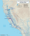
fault-ridden geography of the Tehachapi Mountains, the tunnel plan was scrapped; the water would have to be pumped over the mountains' 3,500-foot (1,100 m) crest...
68 KB (6,093 words) - 23:54, 14 August 2024

Golden Hills, California (category Tehachapi Mountains)
Golden Hills is a census-designated place (CDP) in the Tehachapi Mountains, in Kern County, California, United States. The population was 8,656 at the...
9 KB (839 words) - 05:29, 30 August 2024
1857 Fort Tejon earthquake (category Tehachapi Mountains)
Tejon in the Tehachapi Mountains, and along the San Andreas Fault from Mil Potrero (near Pine Mountain Club) in the San Emigdio Mountains to Lake Hughes...
25 KB (2,834 words) - 08:30, 20 September 2024

Serrano people (category Tehachapi Mountains)
Gabriel Mountains, the Sierra Pelona Mountains, and the southern Tehachapi Mountains. [citation needed] The Serrano populated the San Bernardino Mountains and...
19 KB (2,106 words) - 02:14, 1 October 2024

Pyramid Lake (Los Angeles County, California) (category San Emigdio Mountains)
after being pumped up from the San Joaquin Valley and through the Tehachapi Mountains.[citation needed] This lake was created in 1972, and completed in...
9 KB (772 words) - 06:19, 18 September 2024

Lebec, California (category Tehachapi Mountains)
in Castac Valley between the San Emigdio and Tehachapi Mountains. The community is one of the Mountain Communities of the Tejon Pass. Lebec is 40 miles...
22 KB (1,799 words) - 04:16, 31 July 2024

Geography of California (section Klamath Mountains)
Ranges also include the Tehachapi Mountains, which separate the Central Valley from the Mojave Desert. The Liebre Mountains occupy the northwest corner...
31 KB (3,822 words) - 17:08, 20 August 2024
Gorgonio Pass San Bernardino Mountains San Jacinto Mountains Temecula Valley San Joaquin Valley (South) Kern County Tehachapi Mountains South Coast Ventura County...
6 KB (377 words) - 04:44, 5 May 2024

Alta Wind Energy Center (category Tehachapi Mountains)
The Alta Wind Energy Center is a wind farm located in Tehachapi Pass of the Tehachapi Mountains, in Kern County, California. As of 2022, it is the largest...
15 KB (960 words) - 11:04, 4 May 2024

Sweetwater River (San Diego County) Tehachapi Mountains (Kern & Los Angeles Counties) Tejon Hills (Kern County) Temescal Mountains (Riverside County) Telephone...
81 KB (6,612 words) - 19:01, 1 October 2024

The Mojave Desert is bounded by the Tehachapi Mountains on the northwest, the San Gabriel and San Bernardino Mountains on the south, and extends eastward...
17 KB (1,708 words) - 17:40, 8 August 2024