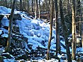
The Zoar Trail is a 6.5-mile (10.5 km) Blue-Blazed hiking trail "system" in the lower Housatonic River valley in Fairfield County, Connecticut and is...
16 KB (2,037 words) - 19:33, 28 May 2024

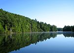
Lake Zoar is a reservoir on the Housatonic River in the U.S. state of Connecticut. It was formed by the completion of the Stevenson Dam, which flooded...
12 KB (994 words) - 19:03, 28 May 2024

recreation area. The Pomperaug trail connects to another trail which provides a path which crosses the Housatonic/Lake Zoar at the Stevenson Dam to the south...
16 KB (2,033 words) - 19:35, 28 May 2024

637139°N 81.456167°W / 40.637139; -81.456167 Intersection with Zoar Valley Trail southeast of Zoar: 40°36′30.6″N 81°25′42.4″W / 40.608500°N 81.428444°W /...
7 KB (760 words) - 17:30, 16 October 2022

million restoration and includes a visitors' center and museum, hiking trails, and picnic area. William Gillette's "castle", called Seventh Sister and...
15 KB (1,305 words) - 04:20, 14 August 2024

Buckeye Trail in Ohio, the Buckeye Trail Association manages several additional trail towns in which services are available to hikers. Dayton and Zoar are...
43 KB (4,031 words) - 19:52, 10 April 2024

Farmington Canal Heritage Trail, also known as the New Haven and Northampton Canal Greenway, is an 82-mile (132 km) multi-use rail trail located in Connecticut...
9 KB (990 words) - 21:16, 10 July 2024

Westwoods Trails is an extensive hiking trail system in Guilford, Connecticut. The trail system has approximately 39 miles (63 km) of trails with features...
5 KB (663 words) - 17:00, 28 April 2024

Zoar Valley is an area of deep gorges along the Main and South branches of Cattaraugus Creek in western New York, United States. The valley is located...
29 KB (3,327 words) - 17:23, 15 June 2024
Regicides Trail is a Blue-Blazed hiking trail, about 7 miles (11 km) long, roughly following the edge of a diabase, or traprock, cliff northwest of New...
8 KB (1,016 words) - 11:20, 31 December 2023

mainline trail (13.3 miles) plus three shorter side or access spur trails. The northernmost point on the trail is at Connecticut Route 34 and Lake Zoar's southern...
21 KB (2,379 words) - 16:32, 1 April 2024
the wolf was codified. Today, the Wolf Den is accessible from a hiking trail off of Wolf Den drive in Mashamoquet Brook State Park, a +1,000-acre (400 ha)...
5 KB (502 words) - 16:46, 26 September 2023

East Coast Greenway (category Rail trails in New York (state))
to Gardiner Rotary Centennial Trail – Benton Lewiston Riverside Trail – Lewiston Lisbon Trail – Lisbon Topsham Trail – Topsham Androscoggin River Bicycle...
44 KB (3,768 words) - 20:25, 2 July 2024

allow. Events and activities The park offers educational films, guided trail walks, and lectures. Warm-month activities include footprint track casting...
8 KB (692 words) - 21:07, 11 August 2024

Sleeping Giant (Connecticut) (redirect from Sleeping Giant State Park Trails)
over 30 miles (48 km) of hiking trails traverse it including 5 miles (8 km) of the 23-mile (37 km) Quinnipiac Trail. Quinnipiac University is located...
22 KB (2,246 words) - 04:24, 8 November 2023

Paugussett Trail Pequot Trail Quinnipiac Trail Regicides Trail Salmon River Trail Shenipsit Trail Tunxis Trail Westwoods Trails Whitestone Cliffs Trail Zoar Trail...
12 KB (549 words) - 20:57, 16 July 2024
Paugussett Trail Pequot Trail Quinnipiac Trail Regicides Trail Salmon River Trail Shenipsit Trail Tunxis Trail Westwoods Trails Whitestone Cliffs Trail Zoar Trail...
3 KB (32 words) - 01:12, 12 July 2024

State Park Trail is a rail trail and linear state park located in Connecticut. The trail is divided into sections designated South (a 25-mile trail from East...
35 KB (2,899 words) - 17:07, 23 April 2024
Bigelow Hollow State Park (redirect from Bigelow Hollow Trail)
at lower elevations and trails can be lost in the thick forest density. The park and forest have over 35 miles (56 km) of trails, including several around...
7 KB (537 words) - 13:07, 3 August 2024

Macedonia Brook State Park (redirect from Macedonia Brook Trail)
51-site campground, picnic, fish, and hike the blue-blazed Macedonia Ridge Trail, which crosses Cobble Mountain and other peaks. The park's first 1,552 acres...
3 KB (156 words) - 16:12, 12 August 2024

Chatfield Hollow State Park (category Hiking trails in Connecticut)
mountain biking trails in the state. Among them are the Lookout Trail and the Pond Trail, which is a side trail that loops off the Deep Woods Trail. Rock climbing...
9 KB (782 words) - 05:35, 6 August 2024

The Ives Trail and Greenway is a 20-mile (32 km) hiking trail in the Housatonic Valley Region (also known as Greater Danbury). Its route connects Ridgefield...
4 KB (614 words) - 20:18, 20 May 2023
Gay City State Park (redirect from Gay City Trails)
campground. The park's trail system, which is used for hiking and cycling, includes a five-mile trail that tours the entire park. Trails also connect Gay City...
8 KB (531 words) - 01:57, 28 December 2023
368 acre open space in Ridgefield, Connecticut. The space has many trails, trail heads and also one of Ridgefield's highest points, at 1,021 feet (311 m)...
3 KB (375 words) - 21:13, 18 June 2024

Paugussett Trail Pequot Trail Quinnipiac Trail Regicides Trail Salmon River Trail Shenipsit Trail Tunxis Trail Westwoods Trails Whitestone Cliffs Trail Zoar Trail...
5 KB (549 words) - 21:20, 18 June 2024
stone formation. The Vista Point cliff, located at the end of the Orange Trail, stands 150 to 175 feet (53 m) above the Eightmile River. Other attractions...
6 KB (582 words) - 03:51, 8 August 2024

encounters three sets of rapids. Hiking trails in neighboring Nepaug State Forest, including the Tunxis Trail, are accessible from Satan's Kingdom Road...
5 KB (285 words) - 01:48, 1 August 2024

Paugussett Trail Pequot Trail Quinnipiac Trail Regicides Trail Salmon River Trail Shenipsit Trail Tunxis Trail Westwoods Trails Whitestone Cliffs Trail Zoar Trail...
23 KB (2,116 words) - 07:09, 13 August 2024

The Menunkatuck Trail is an 11.0-mile (17.7 km) Blue-Blazed hiking trail in Guilford, Connecticut and, currently, is almost entirely on protected land...
10 KB (975 words) - 19:30, 29 June 2024

Paugussett Trail Pequot Trail Quinnipiac Trail Regicides Trail Salmon River Trail Shenipsit Trail Tunxis Trail Westwoods Trails Whitestone Cliffs Trail Zoar Trail...
6 KB (348 words) - 01:47, 16 August 2024