
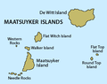
The Maatsuyker Islands are a group of islands and rocks 5.5 kilometres (3.4 mi) off the south coast of Tasmania, Australia. Maatsuyker Island is the southernmost...
19 KB (1,490 words) - 07:09, 2 May 2024

Maatsuyker Islands Group, and comprises part of the Southwest National Park and the Tasmanian Wilderness World Heritage Site. The Maatsuyker Island Lighthouse...
11 KB (572 words) - 20:51, 15 March 2024
Group Hunter Island Robbins Island Three Hummock Island Kent Island Group Deal Island Dover Island Erith Island King Island Maatsuyker Islands Group Chicken...
28 KB (2,214 words) - 01:14, 11 August 2024
Needle Rocks (category Islands of South West Tasmania)
the Maatsuyker Islands Group, and comprise part of the Southwest National Park and the Tasmanian Wilderness World Heritage Site. The Maatsuyker Island Lighthouse...
5 KB (256 words) - 12:31, 3 June 2023

Ile du Golfe (category Islands of South West Tasmania)
of the Maatsuyker Islands Group, and comprises part of the Southwest National Park and the Tasmanian Wilderness World Heritage Site. The island's highest...
4 KB (232 words) - 12:58, 3 June 2023
Island is an island located close to the south-western coast of Tasmania, Australia. The 1.58-hectare (0.0061 sq mi) island is part of the Maatsuyker...
6 KB (208 words) - 01:07, 23 May 2023

Maatsuyker Island Lighthouse is a lighthouse on Maatsuyker Island, Tasmania, Australia. It was the last Australian lighthouse still being officially operated...
4 KB (321 words) - 20:39, 7 March 2022

mainland of Tasmania but not of the state of Tasmania. The Maatsuyker Islands and the Pedra Branca island group, just offshore, are also part of the state of...
5 KB (378 words) - 00:42, 8 July 2023

number of Tasmanian islands are identified as being in island groups, including the Breaksea, Furneaux, Hogan, Hunter, Kent, Maatsuyker, Mutton Bird, New...
34 KB (764 words) - 20:11, 28 April 2024
country) List of islands by area List of islands by population List of islands by highest point Majuli, River Island. "Largest river island". Guinness World...
25 KB (76 words) - 11:22, 29 May 2024

of its first European discoverer on 1 January 1856. Maatsuyker Islands, a group of small islands that are the southernmost point of the Australian continent...
34 KB (4,058 words) - 16:43, 9 February 2024

Houyhnhnm (category Fictional island countries)
north-east, on the mainland with the islands of St Francis and St Pieter further east, and Sweers, Maatsuyker and De Wit islands to the east. The map is somewhat...
9 KB (1,225 words) - 23:00, 27 February 2024
coast of Tasmania, Australia. The 64-hectare (0.25 sq mi) island is part of the Maatsuyker Islands Group, and comprises part of the Southwest National Park...
6 KB (257 words) - 01:02, 23 May 2023

Australia. The irregularly shaped 23-hectare (0.089 sq mi) island is part of the Maatsuyker Islands Group, and comprises part of the Southwest National Park...
5 KB (281 words) - 13:01, 3 June 2023
Island is an island located close to the south-western coast of Tasmania, Australia. The 7.6-hectare (0.029 sq mi) island is part of the Maatsuyker Islands...
4 KB (206 words) - 12:56, 3 June 2023
territory and Maatsuyker Islands in southern Tasmania, occasional visitors to main continent, the first individual returned to King Island in 2015 since...
57 KB (5,637 words) - 00:07, 8 October 2024
Walker Island is an island located close to the south-western coast of Tasmania, Australia. The 15-hectare (0.058 sq mi) island is part of the Maatsuyker Islands...
5 KB (223 words) - 12:32, 3 June 2023

keeper's cottages were renovated into tourist accommodations. The Maatsuyker Island Lighthouse off the southern coast of Tasmania, although fully automated...
33 KB (3,502 words) - 02:28, 30 August 2024

of the Maatsuyker Islands Group, and comprises part of the Southwest National Park and the Tasmanian Wilderness World Heritage Site. The island is listed...
8 KB (472 words) - 01:11, 23 May 2023
List of archipelagos (category Lists of islands)
Two Islands Whitsunday Islands Investigator Group Pearson Isles Kent Group Kingsmill Islands Leschenaultia Islands Louis Islands Maatsuyker Islands Mangrove...
31 KB (2,633 words) - 15:40, 16 September 2024

Mewstone (redirect from Mewstone Island, Tasmania)
the Pedra Branca group, lying 12 kilometres (7.5 mi) southeast of Maatsuyker Island, and 22 kilometres (14 mi) off the south coast of Tasmania. Mewstone...
7 KB (523 words) - 10:49, 19 January 2023
List of place names of Dutch origin (section Islands)
BVI Long Island, New York, USA Manhattan, New York, USA Maria Island, Tasmania, AUS Maatsuyker Islands, Tasmania, AUS New Holland Island, Saint Petersburg...
23 KB (1,913 words) - 11:13, 12 May 2024

islands, the green rosella is one of the commonest birds encountered. It also occurs on offshore islands such as Maria, Bruny, De Witt and Maatsuyker...
31 KB (3,486 words) - 08:18, 30 August 2023
Island is an island located close to the south-western coast of Tasmania, Australia. The 6.25-hectare (0.0241 sq mi) island is part of the Maatsuyker...
5 KB (213 words) - 12:29, 3 June 2023

Main Mavourneen Munday North Maatsuyker (group) Chicken De Witt Flat Top Flat Witch Hen Ile du Golfe Louisa Maatsuyker (island) Needles Round Top Walker...
9 KB (925 words) - 03:49, 24 July 2022
Western Rocks (Tasmania) (category Islands of South West Tasmania)
steep, wave-washed 0.29-hectare (0.0011 sq mi) islets are part of the Maatsuyker Islands Group, and comprises part of the Southwest National Park and the Tasmanian...
4 KB (152 words) - 12:35, 3 June 2023
mounted wood and coal fired beacon. The last staffed lighthouse was Maatsuyker Island Lighthouse, off the south coast of Tasmania, which was automated in...
80 KB (2,949 words) - 08:33, 23 July 2024
The low, flat, 1.95-hectare (0.0075 sq mi) island is part of the Maatsuyker Islands Group, and comprises part of the Southwest National Park and the Tasmanian...
4 KB (155 words) - 12:53, 3 June 2023
Walker Island or Walker's Island can refer to: In Tasmania: Walker Island (Southern Tasmania), near Maatsuyker Island Walker Island (Northern Tasmania)...
289 bytes (69 words) - 04:42, 20 June 2019

Main Mavourneen Munday North Maatsuyker (group) Chicken De Witt Flat Top Flat Witch Hen Ile du Golfe Louisa Maatsuyker (island) Needles Round Top Walker...
7 KB (356 words) - 11:17, 28 January 2024