
A maritime boundary is a conceptual division of Earth's water surface areas using physiographical or geopolitical criteria. As such, it usually bounds...
18 KB (2,015 words) - 08:06, 5 February 2024

-168.97694 The Russia–United States maritime boundary was established by the June 1, 1990 USA/USSR Maritime Boundary Agreement (since Russia declared itself...
5 KB (534 words) - 18:18, 28 March 2024
maritime boundaries are included and are tabulated separately and in combination. For purposes of this list, "maritime boundary" includes boundaries that...
85 KB (2,305 words) - 15:43, 8 June 2024
countries and territories by maritime boundaries with other countries and territories. The list encompasses adjacent maritime nations and territories with...
81 KB (2,633 words) - 23:33, 16 April 2024

Bakassi (redirect from Cameroon–Nigeria Land and Maritime Boundary case)
Maroua Declaration of 1 June 1975, which were devised to outline maritime boundaries between the two countries following their independence. The line...
21 KB (2,117 words) - 08:42, 31 May 2024
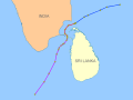
India–Sri Lanka maritime boundary agreements were signed in 1974 and 1976 between India and Sri Lanka to define the international maritime boundary between the...
4 KB (231 words) - 23:51, 8 May 2024
is used when referring to the maritime boundaries, in which case it is called maritime delimitation. The term "maritime delimitation" is a form of national...
3 KB (301 words) - 15:04, 16 May 2024
Territorial waters (redirect from National sea boundary)
and seabed below. In international law, adjustment of these boundaries is called maritime delimitation. A state's territorial sea extends up to 12 nmi...
39 KB (4,880 words) - 15:25, 25 April 2024
This is a list of maritime boundary treaties. Maritime boundary treaties are treaties that establish a specified ocean or sea boundary between two or more...
71 KB (221 words) - 02:23, 12 March 2023

The Canada–France Maritime Boundary Case was a dispute between Canada and France that was decided in 1992 by an arbitral tribunal created by the parties...
7 KB (717 words) - 07:25, 30 April 2024

Border (redirect from International boundary)
Retrieved 24 July 2018. "General info". VLIZ Maritime Boundaries Geodatabase. Retrieved 19 November 2010. "Maritime definitions". Geoscience Australia. Retrieved...
53 KB (5,693 words) - 04:14, 8 June 2024
also includes maritime boundaries along the length of the Straits of Malacca, in the South China Sea and in the Celebes Sea. The land boundary stretches from...
46 KB (5,088 words) - 10:02, 6 November 2023
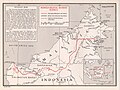
Indonesia include land and maritime borders with Malaysia, Papua New Guinea, and East Timor, as well as shared maritime boundaries with Australia, India,...
66 KB (6,049 words) - 16:11, 1 February 2024
October 2022 and guaranteed by the United States, which established a maritime boundary and ended the dispute between the two countries, opening the way for...
23 KB (2,140 words) - 18:55, 29 February 2024

Almadies served an important role in a 1985 ruling that determined the maritime boundary between the nearby countries of Guinea and Guinea-Bissau. Both Guinea...
8 KB (623 words) - 16:20, 5 February 2024

territories, except where a maritime delimitation agreement exists with another state. To the 12 nautical-mile boundary is Australia's territorial waters...
5 KB (443 words) - 02:30, 2 July 2023
them long. It has maritime boundaries with many countries due to its extensive exclusive economic zone (EEZ). All of its maritime borders with Canada...
12 KB (856 words) - 23:05, 28 May 2024

February 3, 2009, the court handed down its verdict, establishing a maritime boundary including the continental shelf and exclusive economic zones for Romania...
13 KB (1,449 words) - 06:34, 9 July 2023

an overlap occurs, it is up to the states to delineate the actual maritime boundary. Generally, any point within an overlapping area defaults to the nearest...
85 KB (6,024 words) - 11:03, 20 May 2024

in the sector adjacent to Cuban maritime areas (with map), of July 26, 1976. Cuba and United States: Maritime boundary agreement between the United States...
56 KB (6,284 words) - 13:52, 11 May 2024

Adriatic Sea (section Boundaries)
agreed on their maritime boundaries by 1975 and this boundary is recognised by Yugoslavia's successor states, but the maritime boundaries between Slovenia...
186 KB (18,494 words) - 23:22, 1 June 2024

Navassa Island (section Maritime boundary disputes)
purposes of determining equidistant boundary calculation with Cuba during the signing of the Cuba–Haiti Maritime Boundary Agreement in 1977; Cuba backs Haiti's...
38 KB (3,818 words) - 01:19, 24 May 2024

reference, agreed to its maritime borders with the U.S. between Aves Island and Puerto Rico in the United States–Venezuela Maritime Boundary Treaty; this treaty...
13 KB (1,399 words) - 15:58, 28 April 2024
only 25% of what France had sought. The 1992 decision fixed the maritime boundaries between Canada and the islands, but did not demarcate the continental...
74 KB (6,702 words) - 18:56, 3 June 2024
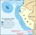
square kilometres (14,600 sq mi) in size. Peru contended that its maritime boundary delimitation with Chile was not fixed, but Chile claimed that it holds...
12 KB (1,459 words) - 00:53, 12 December 2023

Territorial disputes in the South China Sea (redirect from Maritime jurisdiction in the South China Sea)
Philippines, Taiwan, and Vietnam. Maritime boundary along the Vietnamese coast between the PRC, Taiwan, and Vietnam. Maritime boundary north of Borneo between the...
139 KB (14,006 words) - 19:41, 5 June 2024

Bangladesh–India border (section Maritime boundary)
Pyrdiwah. India and Bangladesh, with different perceptions of their maritime boundaries and exclusive economic zone, engaged in eight rounds of bilateral...
30 KB (2,584 words) - 16:30, 7 June 2024

referred as the 49th parallel north which makes up the boundary at parts. To the east: A maritime boundary with the Kingdom of Denmark, at the self-governing...
5 KB (321 words) - 20:49, 29 May 2024

2015. Gray, David H. (Autumn 1997). "Canada's Unresolved Maritime Boundaries" (PDF). IBRU Boundary and Security Bulletin. pp. 61–67. Retrieved March 21,...
288 KB (10,781 words) - 18:37, 4 June 2024

Strait of Juan de Fuca (section Boundary dispute)
The international boundary between Canada and the United States runs down the centre of the Strait. It was named in 1787 by the maritime fur trader Charles...
18 KB (1,906 words) - 04:13, 11 October 2023