
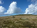
Preseli Mountains (English: /prəˈsɛli/, prə-SEL-ee; Welsh: Mynyddoedd y Preseli or Y Preselau), also known as the Preseli Hills, or just the Preselis...
29 KB (2,739 words) - 10:59, 28 March 2024

exception of the Preseli Mountains in the north. There are many prehistoric sites in Pembrokeshire, particularly in the Preseli Mountains. During the Middle...
129 KB (10,573 words) - 13:50, 1 October 2024

parish in the community of New Moat on the southern slopes of the Preseli Mountains in Pembrokeshire, Wales. The parish includes the small settlement...
11 KB (1,015 words) - 14:32, 11 September 2024
is the site of a possible dismantled Neolithic stone circle in the Preseli Mountains of Pembrokeshire, Wales. The diameter of the postulated circle is...
11 KB (1,120 words) - 21:31, 27 September 2024

approximately 800 feet (240 m) above sea level at the eastern end of the Preseli Mountains, on the old Tenby to Cardigan turnpike road, now the A478. The village...
16 KB (1,490 words) - 18:46, 30 July 2024
Pentre Galar (section Preseli transmitting station)
Galar (or Pentregalar, Pentre-Galar) is a small settlement in the Preseli Mountains south of the village of Crymych, north Pembrokeshire, Wales, on the...
9 KB (882 words) - 09:49, 15 November 2023
Foel Cwmcerwyn (category Mountains and hills of Pembrokeshire)
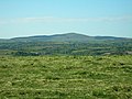
Foel Cwmcerwyn is the highest point of the Preseli Mountains and of Pembrokeshire. Foel Cwmcerwyn lies within the borders of the Pembrokeshire Coast National...
4 KB (227 words) - 02:01, 11 September 2024

roads, including the B4329 running northwards to Eglwyswrw across the Preseli Mountains. The A40 connects Haverfordwest with Carmarthen to the east and Fishguard...
52 KB (5,632 words) - 20:53, 3 September 2024
Carreg-las translates from the Welsh as 'bluestone', a rock found in the Preseli Mountains, in Pembrokeshire, of which it is said Stonehenge was constructed...
10 KB (1,126 words) - 16:09, 28 May 2024
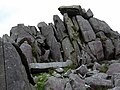
Craig Rhos-y-felin is a rocky outcrop on the north side of the Preseli Mountains in Wales, which is designated as a RIGS site on the basis of its geological...
3 KB (330 words) - 18:43, 17 February 2023

Preseli transmitting station (formerly spelt Presely) is a broadcasting and telecommunications facility on the eastern end of the Preseli Mountains,...
14 KB (1,010 words) - 01:55, 21 September 2023

southwest Wales. It sits below the mountain known as Castlebythe (English: Cow Castle), one of the peaks in the Preseli Mountains, just outside the Pembrokeshire...
5 KB (342 words) - 13:50, 28 July 2024
Cerrigydrudion, Conwy Llys y Fran, on the southern slopes of the Preseli Mountains in Pembrokeshire In January 2016, following the scrapping of Western...
11 KB (1,166 words) - 07:45, 14 June 2024

the entire retriangulation, measuring 98 miles (158 km) between the Preseli mountains (Wales) and Ballycreen in County Wicklow. The statutory three nights...
25 KB (3,015 words) - 09:19, 16 March 2024

small village in north Pembrokeshire, Wales, in the foothills of the Preseli Mountains in the Pembrokeshire Coast National Park. It is in the community of...
6 KB (565 words) - 09:43, 15 November 2023
its junction with the B4329 scenic route to Haverfordwest over the Preseli Mountains. The farm has provided horses for military parades, and H.M. The Queen...
17 KB (1,629 words) - 01:37, 1 September 2024

the bluestone used at Stonehenge, Salisbury, as originating in the Preseli Mountains in Wales. Many items denoting 'rank and prestige' were deposited in...
18 KB (1,937 words) - 15:31, 8 June 2024
the village of Felindre Farchog, Pembrokeshire, Wales, between the Preseli Mountains and the north Pembrokeshire coast. The site is designated as an SSSI...
2 KB (272 words) - 15:49, 17 February 2024

hamlet in north Pembrokeshire, Wales, in the northern foothills of the Preseli Mountains. It is in the parish of Eglwyswen, the community of Crymych and the...
3 KB (238 words) - 09:42, 15 November 2023

B4329 road (section Mountain section)
south, in an approximately southwesterly direction, crossing the Preseli Mountains. It links to the A487 trunk road at both its northern and southern...
13 KB (1,419 words) - 08:02, 16 September 2024

tides. The parish extended from Dinas Head on Dinas Island into the Preseli Mountains and included several small settlements to the north and south of the...
8 KB (789 words) - 14:43, 31 July 2024

or Morfil is a remote upland parish on the southern slopes of the Preseli Mountains in north Pembrokeshire, Wales. Fishguard is 6 miles (10 km) to the...
10 KB (1,020 words) - 20:39, 22 July 2024
largest settlement in the community. It is at the eastern end of the Preseli Mountains, 1 mile (1.6 km) north of Llanfyrnach, with much of the village around...
4 KB (322 words) - 12:06, 19 November 2023

the village of Felindre Farchog, Pembrokeshire, Wales, between the Preseli Mountains and the north Pembrokeshire coast. The volcanic rock of the moor of...
922 bytes (97 words) - 15:03, 4 May 2024
represented. One of the most common rocks in the assemblage is known as Preseli Spotted Dolerite—a chemically altered igneous rock containing spots or...
18 KB (2,061 words) - 12:30, 9 September 2024

(Welsh: Tafarn Newydd) is a hamlet on the southern slopes of the Preseli Mountains in Pembrokeshire, Wales. It sits on the crossroads between the B4329...
2 KB (186 words) - 21:52, 15 September 2024
drawing inspiration from the local landscapes of Cardigan Bay and the Preseli Mountains and the rich, ancient heritage of the region. The group’s first EP...
11 KB (1,430 words) - 13:47, 20 August 2024

age to be found in the British Isles." The River Gwaun rises in the Preseli Mountains near the village and its tributaries have carved heavily wooded steep...
12 KB (1,113 words) - 09:22, 29 August 2024
forms the eastern boundary. The area is part of the foothills of the Preseli Mountains rising to an altitude of 248 metres and is dissected by deep valleys...
6 KB (586 words) - 14:21, 19 June 2023

Whitland. B4329 A487 W of Eglwyswrw A40 at Haverfordwest Crosses Preseli Mountains N to S, reaching 404 metres (1,325 ft); scenic views across south...
135 KB (82 words) - 16:10, 8 July 2024