
Tuolumne City (/tuˈɒləmi/ ) is an unincorporated town in Tuolumne County, California. A census-designated place (CDP) officially known as Tuolumne also...
16 KB (1,577 words) - 22:53, 21 February 2024

38.02; -119.94 Tuolumne County (/tuˈɒləmi/ ), officially the County of Tuolumne, is a county located in the U.S. state of California. As of the 2020...
50 KB (2,127 words) - 03:53, 29 June 2024
The Tuolumne River /tuˈɒləmi/ (Yokutsan: Tawalimnu) flows for 149 miles (240 km) through Central California, from the high Sierra Nevada to join the San...
70 KB (7,726 words) - 19:16, 29 April 2024

seat of Tuolumne County, California, United States. Founded during the California Gold Rush by Mexican miners from Sonora (after which the city is named)...
26 KB (2,112 words) - 00:15, 18 June 2024
County, California, located in the Sierra Nevada Tuolumne City, California, an unincorporated community in Tuolumne County Tuolumne Peak "Tuolumne", a song...
641 bytes (113 words) - 08:55, 13 May 2024

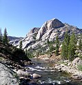
Tuolumne Meadows (/tuˈɒləmi/) is a gentle, dome-studded, sub-alpine meadow area along the Tuolumne River in the eastern section of Yosemite National Park...
12 KB (1,004 words) - 07:13, 29 May 2024
Tuolumne City is a former settlement on the Tuolumne River, originally in Tuolumne County, during the California Gold Rush. The site has been in Stanislaus...
2 KB (186 words) - 01:56, 28 June 2022
The Tuolumne City Memorial Museum preserves the history of this mining and logging town on the western slope of the Sierra Nevada in California. Exhibits...
2 KB (286 words) - 20:50, 26 August 2016

Cherokee, California is a historical mining town site in Tuolumne, California in Tuolumne County, California. The site of the Cherokee, California is a California...
3 KB (291 words) - 01:51, 13 October 2023
properties and districts listed on the California Historical Landmark listing in Tuolumne County, California. Click the "Map of all coordinates" link...
7 KB (105 words) - 21:42, 13 May 2024

Chinese Camp is a census-designated place (CDP) in Tuolumne County, California, United States. The population was 126 at the 2010 census, down from 146...
18 KB (1,659 words) - 07:00, 9 June 2024
meaning "cluster of stone wigwams". Tuolumne City Tuolumne River Tuolumne Grove Tuolumne Meadows Grand Canyon of the Tuolumne Yolo County – from the Patwin...
10 KB (695 words) - 13:47, 9 May 2024

California is a historical farming town site in Chinese Camp, California in Tuolumne County, California. The site of the Jacksonville, California is...
3 KB (206 words) - 01:33, 23 May 2024

Tehama Tuolumne Ventura Trinity "Historical Voter Registration and Participation in Statewide General Elections 1910-2018" (PDF). California Secretary...
42 KB (340 words) - 22:50, 26 June 2024

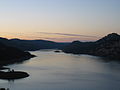
(131 m) high concrete arch-gravity dam in Tuolumne County, California, United States. It impounds the Tuolumne River, forming the Hetch Hetchy Reservoir...
43 KB (4,445 words) - 14:38, 17 June 2024
Don Pedro Reservoir (category Reservoirs in Tuolumne County, California)
of the New Don Pedro Dam across the Tuolumne River in Tuolumne County, California, United States. The California Office of Environmental Health Hazard...
9 KB (736 words) - 12:51, 8 February 2024
Minnesota St. Louis, Missouri Topbar, South Dakota Tracy, Minnesota Tuolumne City, California Verdigris River Vinton, Iowa Walnut Grove, Minnesota Westville...
9 KB (1,146 words) - 09:40, 2 October 2023

Hetch Hetchy (category Landforms of Tuolumne County, California)
the northwestern part of Yosemite National Park and is drained by the Tuolumne River. For thousands of years before the arrival of settlers from the United...
62 KB (6,691 words) - 18:45, 30 April 2024

It was listed on the National Register of Historic Places for Tuolumne County, California in 1983. "National Register Information System". National Register...
2 KB (133 words) - 04:16, 6 August 2023
nation. California is divided into 58 counties and contains 482 municipalities. One, San Francisco, is a consolidated city-county. California law makes...
149 KB (669 words) - 02:37, 1 May 2024

County. State Route 49 then continues northward through the counties of Tuolumne, Calaveras, Amador, El Dorado, Placer, Nevada, Yuba, Sierra, and Plumas...
36 KB (2,930 words) - 12:41, 26 April 2024

occupied the area. European Americans first settled Nevada City in 1849, during the California Gold Rush, as Nevada (Spanish for "snow-covered", a reference...
44 KB (4,071 words) - 05:44, 29 June 2024
The Tuolumne River Regional Park is a large urban park under development along a seven-mile (11 km) stretch of the Tuolumne River between the cities of...
7 KB (946 words) - 11:21, 23 June 2024

Groveland is a census-designated place (CDP) in Tuolumne County, California. Groveland sits at an elevation of 3,136 feet (956 m). The 2020 United States...
13 KB (902 words) - 19:15, 12 June 2024

Central California includes some or all of the following 15 counties: Fresno Kings Madera Mariposa Merced Monterey San Benito Stanislaus Tulare Tuolumne Calaveras...
20 KB (1,379 words) - 00:02, 1 May 2024
Amador, Butte, Calaveras, El Dorado, Placer, Plumas, Sacramento, Solano, Tuolumne, Yolo, and Yuba counties. County Route E1 (CR E1), known as Hot Springs...
45 KB (2,559 words) - 01:21, 30 March 2024

Pit River, Feather River and Tuolumne River. The Klamath and Trinity Rivers drain a large area in far northwestern California. The Eel River and Salinas...
278 KB (24,089 words) - 06:23, 29 June 2024

West Side Lumber Company railway (category History of Tuolumne County, California)
III, Jerry (2012). Tuolumne City. Arcadia Publishing. p. 75. "San Francisco Area". The Western Railroader. 33–34. Northern California Railroad Club. 1970...
9 KB (455 words) - 22:44, 29 November 2023

elevation gain when starting from the Tuolumne Wilderness Office. The hike is easy from Tuolumne Meadows, following the Tuolumne River to the head of the Lyell...
8 KB (680 words) - 00:18, 9 October 2023

Fairgrounds, just east of the city. Because of this, Angels Camp is sometimes referred to as "Frogtown." The city is California Historical Landmark #287....
15 KB (1,473 words) - 23:01, 11 April 2024