
The Delaware Water Gap is a water gap on the border of the U.S. states of New Jersey and Pennsylvania where the Delaware River cuts through a large ridge...
24 KB (2,335 words) - 15:39, 18 October 2024

The Delaware Water Gap is a borough in Monroe County, Pennsylvania, United States. It is located adjacent to the Delaware Water Gap, the pass through...
19 KB (1,277 words) - 17:52, 23 October 2024

The Delaware Water Gap National Recreation Area is a 70,000-acre (28,000 ha) national recreation area administered by the National Park Service in northwest...
17 KB (1,681 words) - 15:29, 18 October 2024
A water gap is a gap that flowing water has carved through a mountain range or mountain ridge and that still carries water today. Such gaps that no longer...
4 KB (378 words) - 14:25, 8 October 2024

The Delaware Water Gap Toll Bridge (also known as the Interstate 80 Toll Bridge) is a toll bridge that carries Interstate 80 across the Delaware River...
5 KB (351 words) - 20:50, 19 September 2024

There are many waterfalls in the Delaware Water Gap National Recreation Area, a national recreation area managed by the National Park Service in New Jersey...
9 KB (1,102 words) - 07:18, 4 September 2024

2 McGeorge, 1905, pp. 3–7 Delaware Water Gap National Recreation Area (pp. 7–8), Obiso, Laura, 2008. Delaware Water Gap National Recreation Area Archived...
62 KB (6,061 words) - 07:07, 17 October 2024

Millbrook, New York, Jaffe first recorded as Del Water Gap. The name was inspired by the Delaware Water Gap. Jaffe cites seeing the name handwritten on the...
22 KB (1,585 words) - 00:20, 4 October 2024

Tocks Island Dam controversy (category Delaware Water Gap National Recreation Area)
River a short distance north from the Delaware Water Gap. In order to control damaging flooding and provide clean water to supply New York City and Philadelphia...
12 KB (1,417 words) - 21:49, 24 March 2024

elements were broken down as follows: Water Gap Rail Station ($32,630,000); right-of-way acquisition at the Delaware Water Gap Station ($1,500,000); Slateford...
59 KB (5,560 words) - 06:01, 19 September 2024

Plate Road 765, Scranton, Pa., to the Delaware Water Gap Spanning the Gap: Pocono Mainline Rail Excursion, Delaware Lackawanna & Western Railroad "Norfolk...
40 KB (4,627 words) - 02:59, 25 July 2024
The Delaware Water Gap is a proposed rail station in Smithfield Township, Monroe County, Pennsylvania, as part of the Lackawanna Cut-Off Restoration Project...
4 KB (253 words) - 23:32, 30 August 2023

Blue Mountain (Pennsylvania) (section Water gaps)
Mountain extends 150 miles (240 km) from the Delaware Water Gap on the New Jersey border in the east to Big Gap in Franklin County in south-central Pennsylvania...
10 KB (920 words) - 09:51, 23 October 2024

bank of the Delaware River to Easton in the Lehigh Valley. The route continues back into rural land and passes through the Delaware Water Gap, at which...
85 KB (8,648 words) - 00:09, 19 October 2024

Delaware, Lackawanna and Western Railroad Water Gap Station is located in Delaware Water Gap, Monroe County, Pennsylvania. Service to Delaware Water Gap...
5 KB (308 words) - 13:34, 6 August 2024

Kittatinny Mountain (redirect from Culvers Gap)
running in a northeast-southwest axis, a continuation across the Delaware Water Gap of Pennsylvania's Blue Mountain (also known as Kittatinny Ridge)....
14 KB (1,805 words) - 02:56, 14 September 2024

region in Northeastern Pennsylvania. They overlook the Delaware River and Delaware Water Gap to the east, Lake Wallenpaupack to the north, Wyoming Valley...
59 KB (5,406 words) - 19:25, 24 October 2024

is 1,526 feet (465 m) tall, and forms the east side of the Delaware Water Gap. Across the Gap is Mount Minsi, on the Pennsylvania side of the river. The...
4 KB (318 words) - 06:17, 27 August 2024

area. In New Jersey, I-80 runs for 68.3 miles (109.9 km) from the Delaware Water Gap Toll Bridge at the Pennsylvania state line to its eastern terminus...
48 KB (3,547 words) - 06:16, 26 October 2024

NY 199. In Pennsylvania, the highway travels through the length of the Delaware Water Gap National Recreation Area, along the southern part of the Poconos in...
63 KB (4,834 words) - 14:11, 10 September 2024
walkway along the Interstate 80 bridge over the Delaware River, ascends from the Delaware Water Gap to the top of Kittatinny Mountain in Worthington...
125 KB (12,241 words) - 20:14, 13 October 2024

Delaware River, gradually moving away from I-80. I-80 continues east into the Delaware Water Gap, entering the state of New Jersey via the Delaware Water...
45 KB (3,060 words) - 20:05, 24 September 2024
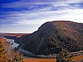
Mount Minsi forms the Pennsylvania side of the Delaware Water Gap, and is the eastern extent of the Blue Mountain. It is composed of sandstone and conglomerates...
4 KB (252 words) - 13:50, 20 July 2024

hills and valleys in three states, out to the Delaware Water Gap National Recreation Area, where the Delaware River separates the ridges of New Jersey from...
5 KB (506 words) - 17:56, 3 June 2024
Michigan Delaware, Missouri Delaware, New York Delaware, Ohio Delaware, Oklahoma Delaware Water Gap, Pennsylvania Delaware Falls, one of 24 named waterfalls...
2 KB (331 words) - 23:36, 15 December 2023

Bushkill Falls (category Delaware Water Gap National Recreation Area)
Pennsylvania in the Pocono Mountains. Water of the Little Bush Kill and Pond Run Creek descends the mountain, toward the Delaware River, forming Bushkill Falls...
3 KB (387 words) - 06:29, 2 July 2024
walkway along the Interstate 80 Delaware Water Gap Toll Bridge over the Delaware River, ascends from the Delaware Water Gap to the top of Kittatinny Ridge...
44 KB (4,497 words) - 13:35, 21 September 2024

the Delaware River on the Delaware Bridge into Pennsylvania, replacing PA 987 north to Portland, where it ended at US 611. The Delaware Water Gap Toll...
63 KB (5,439 words) - 06:05, 26 October 2024

Dingmans Falls (category Delaware Water Gap National Recreation Area)
41°13′50″N 74°53′31″W / 41.23056°N 74.89194°W / 41.23056; -74.89194 Delaware Water Gap Visitor Centers Wikimedia Commons has media related to Dingmans Falls...
2 KB (94 words) - 22:19, 15 December 2022
to the Delaware Water Gap". Trains. Retrieved 11 April 2020. (subscription required) "Spanning the Gap: Pocono Mainline Rail Excursion, Delaware Lackawanna...
9 KB (951 words) - 03:35, 25 December 2023