
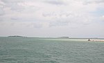
Cape Cod Bay is a large bay of the Atlantic Ocean adjacent to the U.S. state of Massachusetts. Measuring 604 square miles (1,560 km2) below a line drawn...
15 KB (1,816 words) - 20:52, 26 April 2024

Cape Cod is a peninsula extending into the Atlantic Ocean from the southeastern corner of Massachusetts, in the northeastern United States. Its historic...
73 KB (8,603 words) - 14:43, 25 May 2024
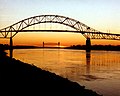
The Cape Cod Canal is an artificial waterway in Massachusetts connecting Cape Cod Bay in the north to Buzzards Bay in the south, and is part of the Atlantic...
22 KB (2,027 words) - 21:21, 27 May 2024

The Cape Cod or Cape Codder is a type of cocktail consisting of vodka and cranberry juice. Some recipes also call for squeezing a lime wedge over the...
5 KB (489 words) - 03:02, 24 May 2024

A Cape Cod house is a low, broad, single or double-story frame building with a moderately-steep-pitched gabled roof, a large central chimney, and very...
9 KB (1,115 words) - 06:53, 14 December 2023

The Cape Cod Canal Railroad Bridge (also known as the Buzzards Bay Railroad Bridge), a vertical lift bridge in Bourne, Massachusetts near Buzzards Bay, carries...
6 KB (450 words) - 09:05, 2 March 2024

The Cape Cod Central Railroad is a heritage railroad located on Cape Cod, Massachusetts. It operates on a rail line known as the Cape Main Line which...
10 KB (867 words) - 17:43, 4 May 2024
Hailed by Cape Cod natives as the "unofficial Cape Cod Anthem, if ever there was one," the song has been credited with "putting the Cape on the map"...
18 KB (2,060 words) - 09:30, 6 April 2024

conditions to San Francisco Bay. Since 1914, Buzzards Bay has been connected to Cape Cod Bay by the Cape Cod Canal. In 1988, under the Clean Water Act, the Environmental...
15 KB (1,405 words) - 19:05, 9 February 2024
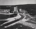
nuclear power plant in Massachusetts in the Manomet section of Plymouth on Cape Cod Bay, south of the tip of Rocky Point and north of Priscilla Beach. Like many...
22 KB (1,545 words) - 13:53, 11 March 2024
coast, Hingham Bay. Massachusetts Bay is itself part of the Gulf of Maine, which extends from Nova Scotia south to Cape Cod Bay. Cape Cod Bay is sometimes...
4 KB (444 words) - 03:35, 13 October 2023

The Cape Codder was a seasonal passenger train operated by Amtrak between New York City and Hyannis, Massachusetts, on Cape Cod. It operated during the...
14 KB (1,159 words) - 17:42, 4 May 2024
Bay State may refer to: Massachusetts, nickname "Bay State," a U.S. state with shores on Massachusetts Bay, Cape Cod Bay, Buzzards Bay and Narragansett...
655 bytes (123 words) - 04:01, 9 February 2024

Massachusetts, United States, Barnstable County being coextensive with Cape Cod. The population of Brewster was 10,318 at the 2020 census. Initially settled...
32 KB (3,282 words) - 04:43, 13 May 2024

in 2013. It is operated by the Cape Cod Regional Transit Authority (CCRTA) in collaboration with the Massachusetts Bay Transportation Authority (MBTA)...
47 KB (4,137 words) - 01:21, 28 May 2024

The Cape Cod Railroad (also currently referred to as the Cape Main Line) is a railroad in southeastern Massachusetts, running from Pilgrim Junction in...
15 KB (1,443 words) - 16:59, 4 May 2024

on Cape Cod. The town motto is Post tot Naufracia Portus, "after so many shipwrecks, a haven". The population was 20,259 at the 2020 census. Cape Cod was...
27 KB (2,582 words) - 02:49, 5 June 2024

Massachusetts. The Patuxet tribe had lived on the western coast of Cape Cod Bay, but an epidemic infection wiped them out, likely brought by previous...
146 KB (19,419 words) - 16:45, 19 May 2024

Truro, Massachusetts (category Cape Cod National Seashore)
vacation community just south of the northern tip of Cape Cod, in an area known as the "Outer Cape". English colonists named it after Truro in Cornwall...
26 KB (2,736 words) - 02:50, 5 June 2024
Plymouth Bay is a small, well-protected bay of the Atlantic Ocean on the western shore of larger Cape Cod Bay along the coastline of the Commonwealth of...
4 KB (487 words) - 14:21, 22 March 2021

stretching south and east from Boston toward Cape Cod along the shores of Massachusetts Bay and Cape Cod Bay. It is subject to varying descriptions including...
24 KB (844 words) - 16:59, 24 April 2024
The Cape Cod National Seashore (CCNS) encompasses 43,607 acres (68.1 sq mi; 176.5 km2) on Cape Cod, in Massachusetts. CCNS was created on August 7, 1961...
10 KB (919 words) - 20:00, 7 January 2024

The Cape Cod Rail Trail (CCRT) is a 25.5-mile (41.0 km) paved rail trail located on Cape Cod in Massachusetts. The trail route passes through the towns...
16 KB (1,441 words) - 16:58, 4 May 2024

sailing vessel Mayflower, which had stopped in Provincetown harbor on Cape Cod Bay after a rough crossing of the Atlantic Ocean, which led to the first...
21 KB (2,211 words) - 02:54, 5 June 2024

lighthouse used as a navigational aid in Cape Cod Bay. Local historians sometimes call it the Atlantis of Cape Cod. The area, which is just south of Great...
7 KB (832 words) - 03:07, 6 March 2022
list of crossings of the Cape Cod Canal from its north end in Cape Cod Bay to its southern end in Buzzards Bay. The Cape Cod Canal, which opened in 1914...
10 KB (833 words) - 14:26, 27 April 2024

census-designated place, Sagamore Beach faces Cape Cod Bay, and the Cape Cod Canal courses through it. Along with Buzzards Bay and Bournedale, it is one of three communities...
10 KB (887 words) - 02:42, 17 May 2024

mansions along the northern Cape Cod Bay coastline, and its warm-water beaches along the southern Nantucket Sound. The Cape Playhouse, in northern Dennis...
39 KB (4,913 words) - 07:20, 9 June 2024
Pleasant Bay is a bay of the Atlantic Ocean just north of the "elbow" of Cape Cod in Massachusetts. It is bounded on the east by a long peninsula and a...
2 KB (214 words) - 20:33, 24 August 2023
The presence of excessive nitrogen-based chemicals in the waters of Cape Cod Bay enters the water faster than it can exit, taking approximately one month...
8 KB (728 words) - 20:28, 11 December 2023